Multi-Day Walks in Ireland
Whether you call it hiking, trekking, going walkabout, or simply taking a stroll, Ireland is the perfect place to do it. There are plenty of walking routes in this small island nation to keep you occupied, most taking between 3 and 11 days to complete. You don't need to be an avid hiker or outdoorsman to participate, either: many of the trails (or "ways," as they're referred to here) are suitable for novices, and walkers typically spend each night sleeping in village lodging along the way.
In this guide, you'll find all the practical information required to plan the perfect multi-day hiking trip. We've also included an in-depth analysis of the best routes. Read on for more info.
Planning Your Trip

When to go
As beautiful as Ireland is, this nation's temperamental climate can be hard to predict. The country does enjoy pleasant temperatures for walking throughout the year, and if you come in the warmer months of May-August you can expect a range of mid-50s to 60s Fahrenheit. Summer months also coincide with Ireland's high tourist season, so you can expect to pay higher prices for lodging along your route. Avoid this with a visit in the shoulder seasons of spring and fall.
No matter when you come or where you go, you'll likely be in for some wet. Ireland is a rainy country, and the east and southeast coasts average about 150 days of rain per year—and on the west coast, this number jumps to as high as 225 days per year. If you come during the warmer months you'll mitigate the chance of enduring heavy rains on your multi-day walk—but if you do encounter some of the famously wet weather, it's part of the authentically Irish experience.
Lodging and food
Perhaps the best thing about multi-day walks in Ireland is the fact that each stopping point is a village or small town, with legitimate lodging options for weary hikers. Depending on the route, this runs from full-service hotels in towns like Dingle to self-catering pubs, inns, and bed-and-breakfasts in remote areas. The availability of meals and supplies follows a similar pattern: routes with lots of developed stops, like the Barrow Way and the Causeway Coast, will have you nicely covered—but you'll need to stock up on snacks and other provisions if heading further off the beaten path. Ask your travel specialist for details.
What to bring
Only you know exactly what to bring to suit your hiking style. Still, we recommend bringing some specific items that will be useful for a (potentially rainy) multi-day walk.
Gear: Investing in trekking poles or a hiking stick is a good idea, and be sure to bring a compass and a durable backpack. For these long-distance hikes, we recommend a 60-liter long-distance pack or a decent-sized rucksack/daypack. You'll need something big enough to carry your food and drink supplies and your extra layers of clothing and rain gear.
Clothing: A good pair of trekking boots is mandatory (preferably leather), as is cold-weather clothing (even if you're traveling during spring, fall, or summer) in order to guard against stormy weather. As mentioned above, plan for rain. Make sure as much of your gear as possible is waterproof, and invest in a waterproof jacket and pants. Your waterproof clothing should be breathable, and make sure the jacket has a good hood and neck collar.
Maps: If you're traveling independently, you can obtain hiking maps from tourism authorities in the specific county of your route. Failte Ireland is the national tourism organization, and they have an extensive network of tourist-information points throughout the country—a great resource for walking maps. Ordnance Survey maps (OS Explorer Maps) are another good resource produced by the Irish government.
Kerry Way (133 miles/215 km) - 5 to 11 Days

This is one of the most famous multi-day hikes in Ireland for the simple fact it takes place in the most popular tourist destination in Ireland: County Kerry. This region of the southwest of the country is famous for being quintessential Ireland, as it's filled with incredible scenery featuring colorful old towns, like Killarney, old castles, mountains, lakes, waterfalls, and of course all those rolling green hills for which Ireland is deservedly famous.
The Kerry Way can be completed in as few as five days or as many as 11, depending on how much of the region you'd like to see. Therefore there are a number of ways to hike the Kerry Way, with most routes starting in the town of Killarney (or the adjacent Killarney National Park), and following a circuit path around the Iveragh Peninsula before returning to the starting point. The famous eight-day Ring of Kerry circuit takes hikers around the stunning cliffs, hidden beaches, and quaint towns of Ireland's Wild Atlantic Way. It runs westward through the postcard villages of Caherdaniel and Waterville, to the coastal white sands of Glenbeigh (at the southern end of the peninsula), around the sandstone Mcgillycuddy Reeks mountain range and the inland lakes before returning to Killarney.
Hike around the Ring of Kerry at your own pace with this 11-day self-guided itinerary. You'll follow the trail between some of Ireland's most charming towns, crossing sites like Killarney National Park, Kenmare Bay, the Beara Peninsula, and Skelling Islands across a variety of the terrain.
Dingle Way (111 miles/179 km) - 8 Days

Also in the southwest of Ireland, and located just above the Iveragh Peninsula, sits the Dingle Peninsula. It's the site of another popular long-distance walk. The Dingle Way is also circuit trek, beginning in the seaside enclave of Tralee, which is the largest town in County Kerry. For those with a relatively good level of physical fitness, the Dingle Way takes about 8-9 days to complete. In that time you'll experience an incredible amount of diversity.
On the way, you'll cross over the shoulder of Mt. Brandon (a)t 952 meters/3,123 feet, it's one of the highest peaks in the country), pass around the sleek foothills of Slieve Mish, march over pastoral farmland, and walk all the way out to the beaches of Slea Head and the Maharees Ayre on the north coast of the peninsula. There are also some fascinating archeological sites on the route, including ancient stone monuments featuring ogham inscriptions. On the Dingle Way, it's never more than a few hours walk between villages so you needn't worry about exhausting your provisions.
See a day-to-day description of the Dingle Way in this 6-day self-guided itinerary. And for more information, see our Ultimate Guide to the Dingle Way.
Chat with a local specialist who can help organize your trip.
Wicklow Way (79 miles/127 km) - 8 to 10 Days

Just south of Dublin you'll find County Wicklow, which sits amid mountainous, upland landscapes altogether different from the flat topography of Ireland's capital city. The Wicklow Way actually begins in Dublin's southern suburban neighborhood of Rathfarnham, leading south-west out of the suburban parkland and over mountainous trails that offer the greatest hits of Ireland's natural beauty.
You'll see a lot on this hike, from upland mountain scenery, highland lakes, and the famous rolling green hills of Ireland's bucolic countryside before finally reaching the trail's terminus in the village of Clonegal, in County Carlow, located south of Dublin. This hike takes an average of 8-to-10 days to complete. If your intention is to commune with nature, marvel at unspoiled natural landscapes, and enjoy a hike in relative remoteness and solitude, then The Wicklow Way is for you.
Combine Ireland's energetic capital with a Wicklow Way walk on this 6-day itinerary, ideal for those who want to experience both the city and countryside. You'll start with two nights in Dublin, followed by four nights traversing the mountain passes and glacial valleys this route is famous for.
Sheep's Head Way (54 miles/88 km) - 4 to 7 Days

The Sheep's Head Peninsula, located at the southern tip of the southwest coast, is one of Ireland's premier destinations for hiking, camping, and anything outdoorsy. This is primarily because the sea views here are objectively stunning. It seems anywhere you go you're treated to sweeping panoramas of green hills and looming mountains running straight out to the craggy cliffs of the rugged coastline (but if you want the real prized wide-angle camera shots for your scrapbook, you'll stop at the Seefin Ridge, which sits at 300 meters/984 feet above sea level).
A 4-to-7-day hike along Sheep's Head Way includes all of this impressive coastal majesty as well as some noteworthy landmarks. It begins in the town of Bantry, in West County Cork, and traces the coastline north around the peninsula before returning to the starting point from the south. The scenery along the way includes coastal mountains and valleys, villages like Ahakista and Kilcrohane, the standing stone pillars of an ancient monastic settlement, the remains of an old copper mine, and an iconic lighthouse at the point of the peninsula. When hiking along the coast be sure to keep an eye towards the Atlantic as you might spot dolphins and whales frolicking just offshore.
You can walk part of Sheep's Head Way on this 8-day trip around two spectacular regions of Ireland's southwest coast. See the highlights of Counties Cork and Kerry, with craggy cliffs and hidden coves formed by the wild Atlantic, historic islands, and more.
Barrow Way (43 miles/70 km) - 4 Days

This walking route is located in Ireland's eastern region and follows along the Barrow River. It covers Ireland's famous Ancient East, which forms the region southwest of Dublin and running out to the Irish Sea. This area is home to 5,000 years of history, which can be seen in the ancient sites and locales you pass through. In fact, the walk starts in the market village of Athy in County Kildare, which itself was settled around 150 CE with the founding of the town occurring in the 12th century.
The route runs south along an old path (originally used for pulling boats and barges down the Barrow) until it reaches Graiguenamanagh, in County Kilkenny, and the ruins of the 7th-century monastery of St. Mullins, a site so old it was once plundered by Vikings around 950 CE. The route is easy, running mostly over flatlands and passing by Ireland's bucolic countryside as well as medieval sites like old stone bridges, castles, mills, lock houses, and abbeys. There are also charming villages at regular intervals, like Leighlinbridge, which make it easy to stock up on supplies. Overall, the Barrow Way is truly a taste of Old Ireland.
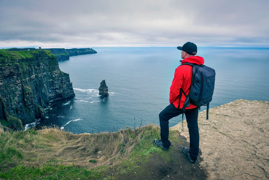
Burren Way (70 miles/114 km) - 5 Days

This relatively brisk multi-day hike, which takes an average of five days to complete, runs inland from the central Atlantic coast. This region is famous for its rocky limestone cliffs dominating the coastline, and you can bet that this route will take you right by the famed Cliffs of Moher (otherwise known to cinema buffs as the Cliffs of Insanity from the feature film "The Princess Bride").
The trail begins in the village of Doolin (the gateway to the offshore Aran Islands) and the Cliffs of Moher on the west coast of County Clare and takes you to the little harbor village of Ballyvaughan on the north coast. The route mainly follows old tarmac roads and forest pathways and tracks, covering the majority of the heartland of the Burren region of County Clare, and features vast expanses of glaciated karst (cracked limestone landscapes) filled with caves and lakes. It's also abounding with fauna, as this environment is home to 3/4 of all of Ireland's plant species.
Traverse the spectrum of the Irish landscape with this 8-day walking excursion from the lunar rocks of the Burren to the coastal routes of Connemara and the remote wildlife of the Aran Islands.
Beara Way (196 km/122 miles) - 8 Days

This hike covers the Beara Peninsula, located on Ireland's scenic southwest coast and straddles west County Cork and south County Kerry. The route begins and ends in Glengarriff, and links the towns of Casteltownbere and Kenmare, but it also passes through a number of colorful villages along the way such as Allihies, Ardgroom, Adrigole, and Eyeries. This easy to moderate hike runs along country roads and is typically completed in about eight days.
What the Beara Way is really known for are its many historical and archeological sites. After all, this route is based partly on the historic march of O'Sullivan Beara in 1603. This was the journey of the Gaelic warrior prince who led his O'Sullivan clan on a perilous 500 km march north from Glengarriff and crossing the Shannon River with the intention of repelling the English invaders. Alas, most of his forces perished along the way.
For hikers attempting the route today, it is (thankfully) much less harrowing than what O'Sullivan Beara experienced. The highlights include many historic sites like old castles, forts, and watchtowers. There are also tombs and ancient megalithic monuments like the circle of standing stones at Uragh. Incredible natural landscapes here include the ranges of Caha and Sliah Mishkish, low sandstone mountains which run along the spine of the peninsula.
Causeway Coast Way (53 km/33 miles) - 3 to 7 Days

On the coast in Northern Ireland, you'll find one of the most famous hikes in the country, one that passes along the iconic Giant's Causeway in County Antrim. The Giant's Causeway is a coastal area comprised of thousands upon thousands of interlocking basalt columns (the result of volcanic fissures) that jut out of the ground and look like an ancient game of building blocks enjoyed by giants. It's ideal for novice hikers, as the terrain is relatively level, and those in decent shape complete the route in about three days (but you can extend it to five or even seven in order to further enjoy the singularly beautiful scenery).
The coastline here is impressive in its own right, as it's home to the Glens of Antrim, which is a postcard-perfect region of the country filled with green pastures, mountain plateaus, waterfalls, coastal cliffs, castles, secluded beaches, and prime views of the sea. The Causeway Coast Way is an easy, linear trail with frequent access points that follows the coast from the tourist towns of Ballycastle and Portstewart, but you can choose to start and end in either one.
Bluestack and Sli Cholmcille Way (130 km/80 miles) - 6 Days

This comprehensive route follows north Ireland's Atlantic Coast and includes the wild Bluestack Mountains, in County Donegal, and the St. Colmcille hiking route, which boasts some of the most incredible coastal views in the country. This route even takes walkers to the craggy Slieve League sea cliffs, which at 600 meters/1,968 feet, are the tallest cliffs in Ireland. There are also major historic sites along the way like one of Ireland's old coastal signal towers (this one at Glen Head and still mostly intact), and the cross-pillar at the coastal district of Glencolumbcille, an old stone monolith featuring early Christian engravings.
The Sli Cholmcille way typically takes six days to complete, and expect to hike long distances on each of those days. That said, it won't be so strenuous as the route mostly follows country roads and easy mountain paths.
Aran Islands (59 km/36 miles) - 5 Days

The last route covers one of the most mythic places in Ireland: the Aran Islands. These three rocky outposts located just off Galway Bay in southwestern Ireland are a throwback to the earliest age of Gaelic civilization. Indeed, Irish is still the predominant language spoken by the locals here, and little of the modern world has encroached. The landscapes of the Arans are denoted by green rocky deserts and intimidatingly high coastal cliffs.
This five-day hike embarks from Galway, with the first two nights spent trekking around the main island of Inishmore. Then it's a transfer back to Galway and a day trip to the island of Inishmaan and the coastal village of Doolin, which resounds with traditional Irish music—one of the best cultural experiences in the country. The end of the hike involves a walk from Doolin to the famous Cliffs of Moher before returning to Galway.
For more great ideas for multi-day walks in Ireland, check out these tours and itineraries.