
Highlights
- Visit both the western and eastern sides of the Sierra Nevada ranges
- Hike to crystal clear alpine lakes including Crystal Lake and Lone Pine Lake
- Visit amazing geological formations such as the Devils Postpile and Obsidian Dome
- See the biggest tree in the world in Sequoia National Park
Brief Itinerary
| Day | Highlights | Overnight |
|---|---|---|
| Day 1 | Drive from the San Francisco Bay Area to Yosemite | Yosemite National Park |
| Day 2 | Explore Yosemite Valley and its many highlights | Yosemite National Park |
| Day 3 | Yosemite to Mammoth Lakes via Mono Lake | Mammoth Lakes |
| Day 4 | Explore Mammoth Lakes | Mammoth Lakes |
| Day 5 | Explore June Lakes Area | Mammoth Lakes |
| Day 6 | Mammoth Lakes to Lone Pine & Whitney Portal | Lone Pine |
| Day 7 | Lone Pine to Sequoia National Park | Sequoia National Park |
| Day 8 | Explore Sequoia and Kings Canyon National Park | Sequoia National Park |
| Day 9 | Kings Canyon Horseback Riding, drive back to San Francisco |
Detailed Itinerary
Day 1: Drive from the San Francisco Bay Area to Yosemite

The drive from the Bay Area east towards Yosemite starts out on busy highways. It's not the most scenic beginning, but the destination is more than worth the journey. After about 2 hours (depending on traffic), the route starts to become more interesting as you pass almond orchards in the Central Valley. Next, you'll begin the steep climb to Groveland (tip: take the Old Priest Grade for a nice, but steep, shortcut with pretty views).
Groveland is a great little town for a quick coffee or bite. Try Cocina Michoacana for a good burrito.
From Groveland, it's another 45 minutes through dense forest to the Evergreen Lodge. On this stretch of road, you start to feel that excitement that comes with heading toward a special destination! Follow the directions and turn left about a mile before you reach the park entrance.
Note: There are many other lodging options in Yosemite as well, including the Ahwahnee Lodge (traditional upscale hotel in the middle of the action in the park) and Curry Village (basic rooms and cabins, also centrally located). Ask your specialist for additional recommendations.
If you arrive early enough during the day, you can take the time to start exploring. Your hotel is very close to the Hetch Hetchy Reservoir. Many visitors to Yosemite skip this part of the park, but you shouldn't! With amazing waterfalls, beautiful wildflowers, and crystal clear alpine lakes, it would be a shame to miss it.
For a short afternoon hike, you can head to the Lookout Point. The 2.5-mile short hike gives you a birds-eye view of the Hetch Hetchy reservoir, the O'Shaughnessy Dam, and Wapama Falls. With a bit more time, you can visit these sights up close. The Wapama Falls Hike (5 miles round trip ) has you first walking over the O'Shaughnessy Dam, where you can see the giant wall (910 feet long) holding back the water in the reservoir. From there, it is an easy, flat hike along the side of the lake past several streams and 2 smaller waterfalls (only in spring), as well as many wildflowers to the main event - Wapama Falls. The bridge in front of the waterfall gives you access to see the falls from all angles. Take a break at the falls before heading back to some well-deserved dinner at your lodge.
See detailed Google Maps for this day
Day 2: Explore Yosemite Valley and its many highlights

Today you'll head to the Yosemite Valley floor to explore some of the most amazing rocks and waterfalls anywhere in the world.
It's about a 20 minute drive to the park entrance, where you'll pay your entrance fee, and then another 30 minutes to the Valley Floor. Enjoy the granite slabs lining the road and get ready for an amazing view of El Capitan and Half Dome as you approach the valley.
Your first stop is Bridalveil Fall. Park on the side of the road and hike up towards the foot of the waterfall. Be careful higher up, as it gets slippery and steep. The big boulders are a great adventure for kids.
As you continue the drive, make sure to look up and to the left to see 3,000 ft high El Capitan ("El Cap") towering above you.
For a great 3.5 mile round trip hike, head to the Happy Isles trailhead and complete the Vernal Falls Hike. This trail can get crowded on busy weekends, but the spectacular Mist Trail right next to the Vernal Falls is worth the experience.
Before or after the hike, you can grab a simple lunch at Curry Village or at the Ahwahnee hotel for a classier meal.
Head back to the Evergreen Lodge to enjoy the campfire and a nice dinner.
See detailed Google Map for this day
Day 3: Yosemite to Mammoth Lakes via Mono Lake

Today, you are heading to the eastern side of the Sierras on Highway 120, through Tioga Pass. Definitely check the road conditions before you start this drive, depending on the year's snowfall, the highway could be closed well into the month of May or even June. Pack a picnic lunch or lots of snacks, as you will be spending most of the morning outdoors, with limited access to restaurants.
The drive from the western side to the eastern side of Yosemite is a treat in itself, as every turn reveals another incredible view. Take your time to meander down the 72-mile road- you've got some great treats to look forward to along the way.
The first stop is Olmstead Point on Tioga Pass road. Just pull over to the small parking lot on the side of the road, and you will be able to see the entire valley including the iconic granite Half Dome. With a pair of binoculars, you can often see a line of hikers climbing up the cable to the top. Don't jump back in your car just yet. Olmstead Point has one of the shortest hiking trails in the park at 0.2 miles. It is well worth the quick walk as it opens up to spectacular views of Tenaya Peak, Tenaya Lake, and Mount Conness.
Your second stop is Tenaya Lake, the largest natural lake in Yosemite. Tenaya is popular for canoeing, kayaking, and sailing. If you visit at the end of summer, you should dip your toes in and see if it's warm enough for a quick swim before you continue your journey.
Your final stopover on the Tioga Pass road is just off the Tuolumne Meadows visitors area. There is a short trail to a large white granite dome called Lambert Dome. It is a popular spot for climbers and offers an amazing view across the meadows. Not a climber? No problem, the base on the dome's backside is also a fun place to walk.
The Tuolumne Meadows area is a great spot to take a short hike and enjoy lunch. The whole family would enjoy hiking to Soda Springs (2 miles round trip). Younger hikers (and their parents) will delight in seeing many river crossings, deer sprinting across the meadows, and, in spring and early summer, fields covered with colorful wildflowers. When you arrive at the spring, you will discover why it is called "Soda Springs". The water bubbling out of the ground is carbonated! Enjoy lunch at the historical Parsons Memorial Lodge before heading back to your car.
For those with a bit more time, Gaylor Lakes Hike (3.5 miles) is also a great option. While the hike is not long, there is an elevation gain of 1,210 feet. The hike starts with a steady climb to a ridge looking out over the high Sierras, including Mt. Dana. At the crest of the ridge, you'll head down towards the Middle Gaylor Lake. From there, you can either turn back or continue to follow the trail to the Upper Gaylor Lake.
As you drive out from the Tuolumne Meadows area and exit the park from the Tioga Pass entrance, you will pass a small town called Lee Vining. We recommend stopping by the Mobile Mart for a spot of late lunch or a snack. Yes, it is a gas station, but hidden inside is the Whoa Nellie Deli that serves up gourmet food, including fish tacos with ginger coleslaw, wasabi créme fraiche, and even mango Margaritas!
From here, head to Mono Lake. It's best to visit towards the end of the day, as there is little to no shade on and around the lake. It is also a wonderful place to watch the sunset and snap some fantastic photos!
Mono Lake is one of the oldest lakes in North America and has been called "California's Dead Sea" because it is 2.5 times as salty as the ocean. The water has such a high mineral content because, as salt and minerals continually wash into the lake from Eastern Sierra streams, they have no outlet. Water only leaves the lake by evaporation, leaving the salt and other minerals behind, and becoming increasingly concentrated and alkaline over time.
One of the most unique features of Mono Lake is its tufa towers. The tufa are formed when freshwater interacts with the highly alkaline lake water and forms white limestone deposits that build over time. The tufa form underwater. You can see Mono Lake's tufas above the waterline because, during the last Ice Age, the lake was much deeper. In recent times, the tributaries feeding Mono Lake have been utilized for farm irrigation, which has also lowered the lake's water level and further exposed the tufa towers.
Start your visit at the visitor center on the west side of the lake. You can see exhibits about the area's history. From there, head to South Tufa on the south shore of the lake. Here, you can take the self-guided nature trail and walk among the dramatic tufa towers. The walk is level and appropriate for all ages. Alternatively, if you are game, there is no better way to get to know Mono Lake than through a guided canoe tour- on the boat, you can get up close to some animals and migratory birds that call the lake home (reservation required).
After the sunset, and when you've taken your fill of photos, head to your accommodation in the Mammoth Lake area. Grab some dinner at The EATery, a restaurant inside the Mammoth Brewin Company- you can't go wrong with their famous burgers.
Day 4: Explore Mammoth Lakes

The Mammoth Lakes area is known for its amazing skiing in winter, but there is even more to do and see in the summer.
Grab breakfast at The Stove before heading out to explore the area. It's best to get to The Stove early, as it often has a line out the door by mid-morning. Grab a booth by the window and order the huevos rancheros or the Stove Special with waffles, fresh fruit, eggs and bacon. Don't forget to order a takeout sandwich or burrito for your lunch later in the day.
After you are fueled up, walk off some of that breakfast with a hike to Crystal Lake. The hike is a short but steep workout. (3.1 miles out and back). Start at the Crystal Crag trailhead, near Lake George, just 5 miles outside of the town center. The trail is well signed and very easy to follow. The climb starts straight away through a series of switchbacks, but the trail is mostly shaded, so you at least have some relief from the brilliant summer sun. Once you reach the crest, you'll see the lake in all its glory in front of you. Take in the views as you start the short descent towards the lake. When you reach the water, take the trail to the east side of the lake, where the slope is gentler. Find a spot for a picnic amidst the wildflowers and beneath the sparkling granite of Crystal Crag. Take a quick dip in the water after lunch before you head back down the mountain. As you head down the trail, you'll be accompanied by amazing views of Lake George, Lake Mary, and even glimpses of Lake Mamie through the pines.
After coming down from Crystal Lake, drive over to the Devils Postpile National Monument. Along the way, you will pass the Earthquake Fault, and it is definitely worth a stopover to see the Earth's mighty forces at work. This incredible fissure is thought to have formed around 600 years ago. The fissure cuts through hard volcanic rock to a depth of 60 feet, and is several hundred feet wide. A short, family-friendly 0.3 mile hike descends deep into the rocky bowels of the fault and winds through majestic stands of old-growth red fir trees, as well as Jeffrey pine and Lodgepole pine. Along the way, several interpretive signs provide information about the natural history, ecology, and preservation of the area.
Continue on to Devils Postpile, formed around 100,000 years ago when a cooling lava flow cracked into multi-sided columns. The formation is a rare sight in the geologic world and ranks as one of the world's finest examples of columnar basalt. Its' columns tower up to 60 feet and display a striking symmetry. From the bottom of the pile, you can see huge chunks that have broken off over time, and gain a great angle on the columns themselves.
From here, backtrack to the junction you passed earlier and take the loop trail to the top of the Postpile. It’s a fairly short climb, and at the top you will get to see how the columns fit together. They look a bit like giant, hexagonal bathroom tiles.
Back at the bottom, rejoin the trail (5.0 miles out and back) and hike toward Rainbow Falls. Plunging 101-feet down, the falls are aptly named for the many rainbows that appear in the mist on sunny summer days. Lounge by the waterfalls, have a snack, and wait for the rainbow effect before heading back to your accommodation to relax for the evening.
For dinner, if you feel like splurging, you can't go wrong with Skadi, where you will find hip Swiss Alps decor and an innovative menu. For more of a family-friendly vibe, try Mammoth Rock ‘n’ Bowl & Brasserie, a modern bowling alley serving French cuisine.
Day 5: Explore June Lakes Area

Today, you are heading north just 15 minutes to the June Lakes area for a relaxing day on the water. The area actually boasts four lakes: June Lake, Gull Lake, Silver Lake and Grant Lake. Your first stop will be at the Silver Lake Resort Cafe for some breakfast. The cafe is small, so be prepared to wait if you come late (it will be worth it). The food is great - think hearty mountain fares such as pancakes, biscuits with gravy, bacon and strong coffee.
After breakfast, rent a kayak from the Silver Lake Resort. Kayaking on Silver Lake is pretty easy, even for beginners. The views are stunning, especially in fall when the leaves change color. You can paddle back into the river and wind deep into the mountains as well if you like.
After the morning paddle, it is time to explore the other lakes. Jump back in your car and take the June Lake loop, which is a short road (16 miles) that connects all the lakes. First, head to Grant Lake, then loop around to June Lake and Gull Lake. The entire loop is full of hidden corners, trailheads and amazing views of the mountains, lakes, trees and cottages, so take your time and explore. Finish your drive at June Brewing Company next to June Lake for a bit of lunch, a pint of beer, and some great views.
After lunch, head to Convict Lake. On the drive down, you will pass Obsidian Dome, just 1.2 miles off Highway 395 on a dusty, unpaved road. If you have a bit of time, it's worth exploring. Obsidian Dome is thought to have formed about 600 years ago when magma hit groundwater on its way to the Earth's surface. The heat turns the water into steam and the magma cools into rock. The blast led to the creation of a gigantic pile of obsidian boulders (known as volcanic glass).
Obsidian can form a sharp edge only a single molecule thick. The naturally occurring sharp fragments led to the use of obsidian for weapons and cutting tools. Local native groups used and traded it across a network that spanned hundreds of miles.
You won't be able to climb up the dome, as it is truly less of a dome and more a huge pile of loose obsidian boulders and rocks. However, its very interesting to see such huge obsidian boulders up close and imagine the journey they took to arrive at this spot.
Continue on to Convict Lake, an oblong-shaped lake filled with water as clear as glass, and boxed in by the steep backdrop of the Sierra Nevada. From here, you can see the 12,241 foot peak of Mount Morrison. Convict Lake was originally carved out by glaciers, and at up to 140 feet deep in some places, it’s one of the deepest lakes in the region. There is a 3-mile long trail that runs around the lake. You can tackle the trail in either direction. On the backside of the lake is a great area for a picnic and some small beach areas where you can try your luck at fishing.
As the sun starts to set, you'll wind down your day at one of the many hot springs in the area. Most of the hot springs are natural and not maintained, so some off-road driving is expected. Wild Willy’s Hot Springs is close by, about 25 minutes from the center of Mammoth Lakes. Hop in the hot spring and enjoy the sensation, taking a relaxed view of the scenery around you. If you are there late at night, relish the lack of light pollution and look for the Milky Way or even some falling stars- on a clear night they're easy to find. This is truly the best way to unwind after an active day.
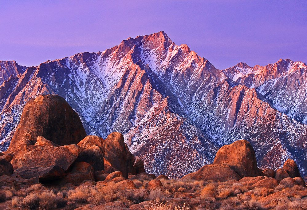
Day 6: Mammoth Lakes to Lone Pine & Whitney Portal

As you head out of Mammoth Lakes this morning, grab a coffee and breakfast at Stellar Brew and Natural Café. With choices like spinach and eggos or bacon breakfast burritos that are ready to go into the warmer, you can get a great breakfast quickly. You have a bit of a drive today, so a quick breakfast and coffee for the road is a good idea.
The first stop of the day is the Crowley Lake Columns (1 hr away). The columns can be up to 20 feet tall, connected by high arches, as if part of an ancient Moorish temple. The columns are on the eastern side of the lake, and to get here, the roads are winding and unpaved, you must have a 4 wheel drive. The best place to see the columns is around a 1/2 mile in, where the columns are over 15 feet tall, and many layers in, so you can walk beneath them. You can read more about the history behind the columns here.
As you head out from Lake Crowley, you will drive by Bishop. This is a good place to stop for some lunch at Erick Schat's Bakkerÿ. This charming desert roadside bakery is known for a special bread, the Original Sheepherder’s Bread, that they have reportedly produced continuously since 1907. They make everything from scratch, including their baker’s yeast, and all their bread is baked in stone hearth ovens, using no preservatives. Grab some lunch, and some olliebollen (deep-fried donuts) for the road, as you head south to Lone Pine.
Only an hour south of Bishop is the quaint town of Lone Pine. As you roll into town, Highway 395 narrows, slows down, and becomes Lone Pine's Main Street. There are Western-style buildings with awnings shading the sidewalk. Check into your hotel, and start exploring the area.
No trip to Lone Pine is complete without visiting the Whitney Portal. From Lone Pine, the road climbs nearly 5,000 feet as it zigzags its way up the face of the Eastern Sierra before reaching Whitney Portal. This is your starting point if you are planning to summit Whitney, and a permit is required. For a taste of the big mountain without the hard-to-get permit, try the hike to Lone Pine Lake. The hike is around 5.1 miles out and back, with a total elevation gain of 1800 feet. Start on the Mt. Whitney Trail up the mountain, take your time climbing up as the elevation can definitely make the hike much harder. When you reach Lone Pine lake you will be rewarded by incredible scenery around the water and views of the whole Owens Valley. Soak in the views and dip your toes in the crystal clear waters before heading down the mountain.
Tonight treat yourself for dinner at Season's in Lone Pine. From the outside, it doesn't look like much, but you will be pleasantly surprised by the menu options - including steak done eight different ways, gourmet pizzas and many different desserts.
Day 7: Lone Pine to Sequoia National Park

Make sure you grab breakfast at Alabama Hills Cafe before you head out of town this morning. This is voted by locals and visitors alike as the best food in Lone Pine. The food is traditional American, but what makes it stand out is its huge portions and fresh ingredients, they only use the best, direct from local suppliers.
After breakfast, head out to the area the cafe was named for, Alabama Hills. The Alabama Hills is a surreal scatter of massive boulders and arches that have been a popular filming location since the silent movie era. Download a self-guided tour brochure if you want to match the scenery you see to classic western movies. Make sure you stop by the famous Mobius Arches rock, where you can see the jagged Sierras framed against round boulders.
From here, you will be driving 4.5 hr hours to the Three Rivers entrance of Sequoia National Park. There are not many great stopovers along the way, so it's best to just make the drive in the afternoon and arrive at the entrance of Sequoia National Park before dark.
Get settled in your accommodation. We would recommend going out for dinner at the Gateway Restaurant and sitting out on the large patio overlooking the Kaweah River as you enjoy your meal.
Day 8: Explore Sequoia and Kings Canyon National Park

Start the day with a hearty breakfast at your hotel- you'll need the fuel, as it will be a busy day of exploring! It's best to prepare a picnic lunch, as there will be many beautiful spots in the park where you can eat with great views. There are restaurants in the park, but this option gives you more freedom to enjoy points of interest along the way in your own time.
Start the day driving through the Generals Highway that runs through Sequoia and Kings Canyon National Parks. This is one of the most beautiful drives in the park and maybe even in the state! Roll down the windows and savor the way the crisp smell of the trees permeates the air - in this case, the journey really is as good as the destination. Your first stop is at the Giant Forest Museum. As you get out of the car, you will be hit by the size and smell of the sequoias all around the parking lot. Standing next to the Giant Sequoias for the first time is a true "wow" moment. The museum is a great starting point for your visit- you can learn the story of the Giant Sequoia and the unique ecology of the area and its trees.
After your visit to the museum, take the road towards Moro Rock. Moro Rock is a short but strenuous climb to a fabulous viewpoint in Sequoia National park. Begin at the Moro Rock parking area and be prepared for a 40 minute, 0.6 miles (400 steps) trek to the summit. You will be treated with views of the Sierras and the snow-capped Mt. Whitney in the distance.
After you descend Moro Rock, continue down the Crescent Meadow Road 0.75 miles to the Tunnel Log. This is a passageway that was carved into a fallen sequoia tree. Take a photo of yourself driving (or walking ) through the tunnel before you head back on the road and continue northbound on the General's Highway.
The next stop is the famous General Sherman Tree. The General Sherman Tree is the world's largest tree by volume. Its 275 feet tall, and has been growing for 2,300 to 2,700 years! It's a half mile stroll just to walk around the tree! Take the General Sherman Trail, a short walking trail that wanders through this grove of giant trees. There are lots of picnic tables in the grove, so this would be a good spot for a lunch break if you are hungry.
The next stop is at Grant Grove. Take the General Grant Tree Trail to the second-largest Giant Sequoia in the world. President Coolidge proclaimed it the Nation's Christmas tree in 1926. Visit the historic Gamlin Cabin and the Fallen Monarch along this 1/3 mile (.5 km) paved trail as well. Near this grove of sequoia is the Grant Grove Village, with a market for buying some snacks, and a number of different restaurants and cafes for lunch if you opted not to picnic.
After you are rested, it's time to continue on to the Kings Canyon Scenic Byway (Highway 180). The road winds along the mountain and descends into Kings Canyon. This road is very winding, its 30 miles long, but expect it to take an hour or more to drive with stops along the way.
There are a number of waterfalls along the way. The first stop is Grizzly Falls- the falls are just off the main highway. Continue on to Roaring River Falls just off the Cedar Grove Area. You can quickly access the falls via a paved, short 0.3 mile walk. As the water forces its way through a narrow granite gap and races down a short 40-foot drop, the theatrical sound demonstrates the reason for the falls' name.
Finally, as you continue on, you arrive at the aptly named "Road's End." Here, you will find yourself at the bottom of the canyon and presented with the beautiful Zumwalt Meadow. This is a lush, serene contrast to the powerful rock formations all around. A 1.5-mile self-guided trail circles the area and offers magnificent views of high granite walls, verdant meadows, and the free-flowing Kings River. Take a walk around the meadows, before heading to your accommodation near Cedar Grove areas for the night.
Day 9: Horseback Riding in Kings Canyon National Park and back to San Francisco

This morning, wake up early for breakfast at your Sequoia & Kings Canyon National Park lodging. Your tour of the Sierra Nevada will be ending today. Before you head home, spend the morning horseback riding in Kings Canyon, a truly unique way of experiencing the park.
You'll meet your guide at Cedar Grove, and you will get matched with a horse right for your experience. Depending on the length of your ride, there may be different trails you can take. For shorter rides, you may be heading to Mist Falls or Upper Bubb's Creek. For longer rides, you will ascend trails that reach elevations of 10,000 feet, with views of volcanic lakes or range basins. Enjoy the spectacular scenery one last time.
After the ride, take a short break at the Grant Grove Village, have lunch, and enjoy a last walk through the Sequoia grove before starting your drive back. The drive back is around 4 hours- the towns of Fresno or Merced along the way are quite nice to stop by for a coffee or an ice cream and to stretch your legs.
Looking for more California road trip ideas? Check out kimkim's top 5 road trips in Northern California.
Map
