Hiking in Landmannalaugar, Landmannalaugar
Overview
Set within the Fjallabak Nature Reserve in Iceland's southern highlands, Landmannalaugar is a popular hiking destination known for its various trails. You'll find incredibly scenic routes set amongst colorful rhyolite mountains, blue lakes, and geothermal hot springs—truly a hiker's paradise! It's just about 2.5 hours from Reykjavík.
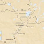
There are various driving routes to Landmannalaugar, all reachable by Iceland's network of gravel mountain roads, often called F-roads. The easiest one avoids a river crossing yet offers impressive views of the Thjorsa Valley and several waterfalls, including Haifoss. The other scenic route takes you through the spooky Domadalur "Valley of Doom," but requires a couple of river crossings. Either way, the paths eventually converge as you pass Ljotipollur and Frostastadavatn Lakes.
Upon arrival in Landmannalaugar, purchase the official hiking map and choose from many exciting options. Even the short routes give you incredible views of the surrounding landscapes! Some popular hikes include Brennisteinsalda (the red mountain) and Blahnukur (the blue mountain), both offering an optional dip in the natural geothermal hot pool by the hut. If the sky is clear, then the view from Blahnukur is simply astonishing!
Landmannalaugar is also the starting point of the 33-mile (54-km) multi-day hut-to-hut Laugavegur Hike. The huts along the way are located at the dark edge of the rhyolite lava field called Laugahraun, close to a few hot springs, which create excellent bathing conditions in a natural brook. You can stay overnight at either the campsite or in the huts.
Discover more hiking opportunities in Iceland.
Like what you see?
Chat with our local specialists and let us help you customize your trip with experiences like this.
Get startedLike what you see?
Chat with our local specialists and let us help you customize your trip with experiences like this.
Get startedItineraries with Hiking in Landmannalaugar


Western and Southern Iceland - 9 Days
Experience the best of Western and Southern Iceland on this 9-day tour: volcanoes, fjords, red and black sand beaches, glaciers, hot springs, wildlife and more.


Volcanic Trails: The Wild Strútur Trail - 5 Days
This trek will take you along the south side of the imposing Torfajökull Volcano with its distinctive red, pink, orange, and blue-green stone, past the deep blue Álftavötn...


Volcanic Trails: The Backroad to Landmannalaugar - 3 Days
From brightly colored rhyolite mountains in shades of red, pink, green, and gold to vast 500-year-old lava fields, this three-day trek will take you through the unique,...


Hiking in Iceland's Highlands: Laugavegur Trek - 7 Days
Embark on the famed Laugavegur Trail on this seven-day Icelandic trek. Journey through active, geothermal lava fields, the Rhyolite Mountains, and snow-covered passes. Cross...
Iceland Experiences
Show more Iceland experiences
Puffin Tour Snæfellsnes Peninsula
Just off the coast of the Snæfellsnes Peninsula near the town of Grundarfjörður is the small island of Melrakkaey, complete with towering sea cliffs of basalt columns. These...

Seljalandsfoss Waterfall
Standing at 200 feet (60 m) is the Seljalandsfoss Waterfall, one of Iceland's most famous and visited cascades. Just off the Ring Road, you can see Seljalandsfoss in less than...

Hike Geldingadalir Volcano
Hiking on an active volcano is one of those once-in-a-lifetime experiences that attract many travelers to Iceland's Geldingadalir Volcano. Set just south of the capital on the...

Hiking Kaldbakur Mountain in the Westfjords
In terms of hiking the mountains of Iceland, the locals may consider the route up Mt. Kaldbakur, the highest point in the Westfjords, as relatively easy. This declaration is...

Canyons & Glaciers near Vík
Along the southern portion of Iceland's famed Ring Road is the humble coastal town of Vík, an excellent starting point for exploring some of the country's canyons and glaciers....
Best of Iceland's Highlands
Best of Iceland's Highlands

Hiking in the Highlands: Iceland's Volcanic Trails
Get off the beaten track and discover Iceland’s otherworldly volcanic landscape on a multi-day hike in the country’s less traveled Highlands region. Choose one of these 3...

Iceland’s Highlands: The Ultimate Guide to Getting off the Beaten Path
Iceland’s interior is by far its most rugged area. The terrain can be tough, and the F-roads are only accessible by jeeps with 4WD (in Winter, only by modified “super jeeps”)....


Guide to Landmannalaugar: Where to Hike, Stay & Play
Landmannalaugar is a geothermal wonderland in the Fjallabak Nature Reserve, home to lava fields, hot pools, and steam puffs that rise from the earth. Hike among vibrantly hued...


Guide to Thorsmork - "Thor's Valley", Home to Some of Iceland's Most Striking Landscapes
Thorsmork is a mountain range nestled between major glaciers Tindfjallajökull, Mýrdalsjökull and Eyjafjallajökull. The ridge, named “Thor’s Valley” in Icelandic, is a dramatic...

Best Things to Do in Reykjavik
Reykjavik, the Icelandic capital, is an excellent hub for exploring some of the country's famed natural surroundings. From the city, discover wildlife like seal colonies and...
Trip Planning Essentials

How kimkim Trips Works in Iceland
Travelers love Iceland for its wild landscapes, Reykjavík's cultural charms, and the seasonal magic of the northern lights. Work with a kimkim travel specialist to experience it...


Ultimate Iceland Itineraries: 5, 7, 10 & 14 Days
When it comes to planning the perfect Iceland itinerary, we have you covered. Our researchers scouted the island, our Iceland experts chipped in, and then we asked travelers...

Iceland Travel Agents
Kimkim has selected the best Iceland travel agents so you'll have a worry-free trip


