Hiking the Thórsmörk Valley, Thórsmörk


Overview
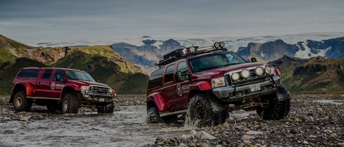
As you hike through the area, take note of the ash and lava flows from the 2010 eruption of Eyjafjallajökull. The viewpoints are endless, and you can spend days hiking up mountains, along cliffs, and to waterfalls, volcanoes, and glaciers. The trails and terrain vary, sometimes with necessary glacier river crossings (but don't attempt to cross the glacial river Krossá by foot; always use the available bridge).
When planning your hikes, you can purchase a Þórsmörk Trail Map at the Volcano Huts. There are several trails from which to choose, including the following:
Þórsmörk Panorama Trail leads you up and over the peak of the Valahnúkur mountain, where you get an impressive 360° view of Þórsmörk. From the top of Valahnúkur, head down to the Langidalur Hut before heading back to the Volcano Huts through the birch woods of the Húsadalur Valley. The trail is well-marked and accessible, with artificial steps on its steepest parts.
Þórsmörk Highlights features all the best views of Þórsmörk and versatile terrain. The trail leads you through the birch woods of the Húsadalur Valley and up to the foothills of the Tindfjöll Mountains, where you turn onto the last part of the Laugavegur Hiking Trail and descend back to the Volcano Huts.
Tindfjöll Circle gives you a beautiful view over the Þórsmörk Nature Reserve, but the rewards come with challenging terrain. Start by heading out over to the Langidalur Hut, and from there, ascend to the foothills of the Tindfjöll Mountains. Next, make your way around the Tindfjöll Mountains to the Stangarháls Ridge and descend a steep trail to the Krossá riverbed. Finally, head back to the Volcano Huts from the bottom of the valley or extend the trek by hiking over the Valahnúkur mountain or strolling through the Langidalur and Húsadalur woods.
Merkurrani Plateau Trail leads you up to the foothills of the Valahnúkur Mountain to the Merkurrani plateau and then south in the direction of Eyjafjallajökull. You'll reach the steep Merkurrani Cliffs, where the Krossá River carves a sharp edge to the volcanic rock. From the cliffs, enjoy the view over the Krossá River, Eyjafjallajökull, and the surrounding mountains of Þórsmörk. Next, head down to the black sands of the Markarfljót Riverbed where the contrasts of the volcanic ash and the green hills of Þórsmörk are very clear. On your way to the Volcano Huts, make time for a short stop at the Sóttarhellir Cave.
Stakkholtsgjá Canyon is on the south side of Krossá. Start by traversing the Krossá River on a footbridge close to the canyon and enjoy an impressive view of the 330-foot-high cliffs (100-m). The riverbed leads you to a narrow passage that ends at the Stakkholtsgjá Ravine. Next, climb a pile of large boulders to enjoy views of a beautiful waterfall. The canyon offers an easy but rewarding hike.
Discover more hiking opportunities in Iceland.
Like what you see?
Chat with our local specialists and let us help you customize your trip with experiences like this.
Get startedLike what you see?
Chat with our local specialists and let us help you customize your trip with experiences like this.
Get startedItineraries with Hiking the Thórsmörk Valley


Iceland Remote Hiking Adventure - 10 Days
This active 10-day itinerary highlights two major hiking areas in Iceland: the southern highlands and the Westfjords. Start off with a bus trip to Thorsmork for a plethora of...


Hiking in Thorsmork - 2 Days
Explore Thorsmork, the valley of the mighty Thor. Cross rugged terrain in a Super Jeep and hike in the remote wilderness of southern Iceland on this 2-day itinerary. Discover...

Hiking Þórsmörk, Fimmvörðuháls & Þríhyrningur - 3 Days
Follow the Þórsmörk, Fimmvörðuháls, and Þríhyrningur hiking and biking routes through stunning valleys, along exposed ridges, and across gravelly rivers. Trek next to the...


Golden Circle, South Coast, & Thorsmork - 5 Days
This fast-paced Icelandic trip spans three regions—the Golden Circle, South Coast, and Thorsmork—and offers plenty to see over the course of five days. Explore Þingvellir...
Iceland Experiences
Show more Iceland experiences
Puffin Tour Snæfellsnes Peninsula
Just off the coast of the Snæfellsnes Peninsula near the town of Grundarfjörður is the small island of Melrakkaey, complete with towering sea cliffs of basalt columns. These...

Seljalandsfoss Waterfall
Standing at 200 feet (60 m) is the Seljalandsfoss Waterfall, one of Iceland's most famous and visited cascades. Just off the Ring Road, you can see Seljalandsfoss in less than...

Hike Geldingadalir Volcano
Hiking on an active volcano is one of those once-in-a-lifetime experiences that attract many travelers to Iceland's Geldingadalir Volcano. Set just south of the capital on the...

Thórsmörk Super Jeep Experience
Perfect for adventure seekers and nature lovers, this full-day excursion takes you deep into the dramatic landscapes of Þórsmörk (Thórsmörk) with the help of an expert guide and...

Hiking Kaldbakur Mountain in the Westfjords
In terms of hiking the mountains of Iceland, the locals may consider the route up Mt. Kaldbakur, the highest point in the Westfjords, as relatively easy. This declaration is...
Best of Thorsmork
Best of Thorsmork

Guide to Thorsmork - "Thor's Valley", Home to Some of Iceland's Most Striking Landscapes
Thorsmork is a mountain range nestled between major glaciers Tindfjallajökull, Mýrdalsjökull and Eyjafjallajökull. The ridge, named “Thor’s Valley” in Icelandic, is a dramatic...

Best Hiking Experiences in Iceland
As cliche as it sounds, Iceland is truly a hiker's paradise. Large swaths of the country (like Thórsmörk Valley and Landmannalaugar) are simply devoted to hiking. You can enjoy...


Hiking Thorsmork - Day Tour
From striking glacial formations to richly green valleys, Thorsmork offers some of the best views in all of Iceland. On this convenient day trip, you'll get the chance to hike...

Thorsmork Super Jeep Adventure - Day Tour
Drive through rivers, canyons, and highlands to explore one of Iceland's most iconic natural destinations. From imposing glaciers to lush hills, Thorsmork's varied landscape is...

Hiking in Thorsmork - 2 Days
Explore Thorsmork, the valley of the mighty Thor. Cross rugged terrain in a Super Jeep and hike in the remote wilderness of southern Iceland on this 2-day itinerary. Discover...
Trip Planning Essentials

How kimkim Trips Works in Iceland
Travelers love Iceland for its wild landscapes, Reykjavík's cultural charms, and the seasonal magic of the northern lights. Work with a kimkim travel specialist to experience it...


Ultimate Iceland Itineraries: 5, 7, 10 & 14 Days
When it comes to planning the perfect Iceland itinerary, we have you covered. Our researchers scouted the island, our Iceland experts chipped in, and then we asked travelers...

Iceland Travel Agents
Kimkim has selected the best Iceland travel agents so you'll have a worry-free trip