
Highlights
- Explore the history of the gold rush with a visit to Sacramento and Marshall's Gold Discovery State Park
- Take the plunge down the exciting whitewater rapids on the American River
- Enjoy a hike to Donner Peak and the panoramic views of the Truckee Basin
- Take sunset photos in Sand Harbor and enjoy a show under the stars
- Explore the jewel of Lake Tahoe - Emerald Bay and Eagle Falls
Brief Itinerary
| Day | Highlights | Overnight |
|---|---|---|
| Day 1 | Old Sacramento & Gold Rush History | Coloma, California |
| Day 2 | South Fork American River Rafting | North Lake Tahoe |
| Day 3 | Donner Peak and Mount Judah Loop Trail | North Lake Tahoe |
| Day 4 | Sunset at Sand Harbor State Park | North Lake Tahoe |
| Day 5 | Truckee River Rafting Half-Day Trip | North Lake Tahoe |
| Day 6 | Day trip to Eagle Lake and Emerald Bay | Lake Tahoe |
| Day 7 | Return to San Francisco | San Francisco |
Detailed Itinerary
Day 1: Old Sacramento & Gold Rush History

Start the day by learning a bit about gold history in Old Sacramento. This storied town was built almost overnight when veins of gold were discovered in the Sierra Foothills in 1849. A massive tide of humankind, all intent on finding their fortune, raced to the Gold Country. Sailing as close as they could get to the gold via waterways, they pulled anchor at San Francisco Bay and sailed east on the Sacramento River. The gold-hungry prospectors were forced to pull up at the confluence of the American and Sacramento Rivers. At this spot, Sacramento was born, with many buildings constructed out of leftover ship timbers and sails.
As you walk through Old Sacramento (now a preserved National Historic Landmark), you can get a sense of the raucous early years. Take your time to stroll through the cobblestone streets and restored buildings. Spend some time in the excellent museums, including the Sacramento History Museum which displays Gold Rush artifacts and offers underground tours and ghost tours of the historic district.
Grab some lunch in the Old Town, or inside the restored paddlewheel boat - the Delta King.
After lunch, continue to the tiny town of Coloma, home of the Marshal Gold Discovery State History Park. In 1848, James W. Marshall found shining flecks of gold in the water channel below the sawmill he was building in partnership with John Sutter. This discovery changed the course of California history, as well as the larger nation. See a replica of the original sawmill and over 20 historic buildings including exhibits on mining, Chinese stores, and a schoolhouse. You can also join a tour to hear the stories of the valley before and during the Gold Rush. After the tour, grab a pan, take a gold panning lesson and try your luck searching for some gold on the American River.
Luckily you won't have far to go after all this activity- you will be staying at a cabin right next to the river tonight. Settle into your cabin and contemplate your own fortunes as you enjoy the river views.
Day 2: South Fork American River Rafting

Today, you will be braving the rapids of the South Fork of the American River on a whitewater raft. This is an easy class 2-3 river that is fun for the whole family (minimum age is 7 years old). A typical trip is around 11 miles down the river, which lasts 3 to 4 hours.
You will meet your guide in the morning and get set up with the right gear and safety instructions. After jumping into the raft, you will start with a few miles of warm-up rapids to get used to maneuvering and balancing in the boat. Once you are seasoned rafters, you will enter the steep granite canyon known as the "Gorge," where rapids occur more frequently. There are a number of Class 3 rapids with fun names such as "Bouncing Rock" or "Hospital Bar," and also smaller rapids as well as safe places for swimming.
After rafting, have lunch on a nice meadow on the banks of the river before drying off and heading back to the car. You still have a little ways to go to your hotel on the North shore of Lake Tahoe.
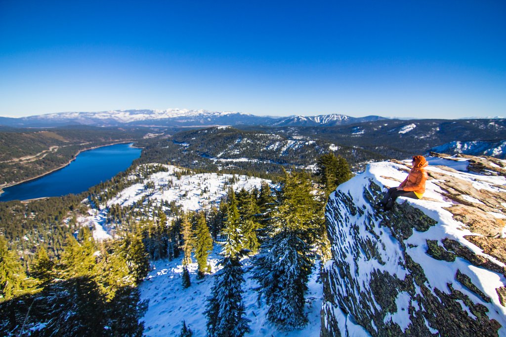
Day 3: Donner Peak and Mount Judah Loop Trail

Donner Peak and Mount Judah Loop Trail is a 4.8 mile popular hiking route near the town of Truckee. The trail is accessible all year, and during the spring and summer months, it features beautiful alpine lakes and wildflowers. In the winter, it is best done as an out and back hike with snowshoes. The trail has around 1300 ft of elevation gain, so you might want to consider other alternatives for children under 10 years of age.
From Truckee, head west on Hwy 80 and exit on Donner Pass Road. Drive past Donner Lake and start climbing into the mountains. You'll know you are close when you drive over Donner Summit Bridge. Just past the bridge is a building for the Alpine Skills Institute with a parking lot on the left-hand side. This is the parking lot for the trailhead.
From the trailhead, you'll follow a portion of the Pacific Crest Trail as it begins climbing through a series of switchbacks up the mountain's northern face. As the trail ascends, you will overlook Lake Mary, which often freezes over in winter. Continue with the climb and soon you will see the lifts and slopes of Sugar Bowl ski resort. Here, you will split with the Pacific Crest Trail and bear left towards a thickly wooded area.
A short time later, the granite formation leading to Donner Peak can be seen. Veer off from the trail at this point and climb to the top of the rock stacks for a view over Donner Lake and the Truckee basin.
From Donner Peak, you can look west and see the radio reflectors atop Mount Judah. Retrace your steps from Donner Peak back to the trail and begin the final, 300-foot climb to the ridge south of Mount Judah. Take in the sweeping 360-degree panorama of lakes, mountains, and forests. If you have packed lunch, this is a great place to enjoy it before heading back down the mountain. On the way down, we'll take the Pacific Crest Trail back to the trailhead.
Hike length: 4.8 miles
Time: 3 - 4 hrs
Elevation gain: 1300 ft
After the hike, take some time to visit downtown Truckee. Truckee is a town rich in history with a quaint downtown that hosts charming shops and superb restaurants set in authentic historic buildings. Visit Tahoe Oil & Spice tasting room located next to the train station and the California Welcome Center. There are over 50 types of extra virgin olive oils and infused balsamic vinegar to choose from. Take a bottle home as a souvenir.
For dinner, consider Truckee Tavern & Grill. Ask for a table on the patio where you can watch the people strolling the streets and the trains rattling by. Another local favorite is the Pianeta located in one of the historic buildings that line the main street. Pianeta specializes in delicious Italian foods with the highlights being the homemade pasta and sausages on the menu.
Day 4: Sunset at Sand Harbor State Park

Located on the northeastern shore of Lake Tahoe, Sand Harbor State Park is very popular with photographers, and it's easy to see why. With crystal-clear waters and dramatic giant white boulders, this is a favorite destination for many visitors.
The state park can get busy during the summer season. Today the plan is to visit a little later in the afternoon and avoid the peak period between 11 am and 3 pm. With the extra time on your hand, consider grabbing lunch in Incline Village first. A great option for lunch here is the iconic Austin's, which has been a local favorite for over 25 years. Try it's famous chicken fried steak or the famous Doug’s Salad.
After lunch, head to Sand Harbor State Park, hopefully, the parking lot will be a bit less full now, but if needed you can park at Incline Village and take the shuttle into the park.
At the main beach, rent a kayak (or standup paddleboard) from Sand Harbor Rentals to explore the interesting coastline. A guided tour is also available.
At sunset, take the time to walk through the short trails in the park and take some beautiful photos of the lake with the magnificent mountains in the background.
If you are visiting during the summer, there are performances scheduled nearly every night in July & August. Grab some food from the Sand Harbor Grill (or pack a picnic) as you enjoy your performance under the stars.
Day 5: Truckee River Rafting Half-Day Trip

A fun-filled rafting trip awaits today. You begin your leisurely float in Tahoe City along a peaceful stretch of the Truckee River. This is a self-guided trip, as the rapids are small, and it is a fun way for the whole family to enjoy the day on the river. You will float through tranquil stretches of scenic meadows, ponds, and small rapids.
The trip takes approximately 2 - 3 hours. You can bring a small cooler with snacks and drinks to enjoy along the way.
You will end your rafting trip at River Ranch Lodge Restaurant & Bar. Enjoy a well-deserved and hearty lunch on the patio, featuring many local and organic ingredients.
After the leisurely lunch, head to Tahoe City to pick up the car. While you are there, why not explore the city a bit more. The Lakeside trail starts right at the visitor center in the center of Tahoe City, and you can follow it along the north side of the lake, or take the south fork. The trail goes all the way to Homewood, but you can take it as far as you want. One idea is to take the south fork. Learn a bit more about Tahoe city history with a stop by the Lake Tahoe Dam and the Commons Beach Jail. Then continue on, 2.3 miles, to the Sunnyside restaurant and lodge on the west side of the lake. Grab a drink there before heading back to Tahoe City. If you want to, the Commons beach in the center of town is great to just hang out for some sunbathing. For dinner with the most amazing sunset views, consider Christy Hill Lakeside Bistro, or Moe's Original Bar B Que. Both have patios with amazing views of the lake.
Day 6: Day trip to Eagle Lake and Emerald Bay

Grab breakfast at your hotel, and a sandwich for a picnic later on today as you will be heading out for a busy day of hiking and exploring.
Today, your destination is the well-known Emerald Bay and the lesser-known, but just as amazing Eagle Falls and Eagle Lake. The trailhead for Eagle Lake is just opposite Emerald Bay, but do come early as there are a limited number of parking spots, and it fills up quickly. The trail is short but steep, only 2 miles out and back, with a 450 ft elevation gain. Around a quarter of the mile into the trip, you will see Eagle Falls. The falls are most impressive in spring with a large volume of water cascading down the granite and into Lake Tahoe below. In the fall, the colors of the birch trees near the falls also make for beautiful photos.
After taking your fill of photos at the falls, you continue on to the lake. Eagle Lake is a typical alpine lake, surrounded by granite peaks, and on a calm day, the water is a still as a mirror, reflecting the peaks in their midst. In early summer the water is usually too cold to even dip your feet in, but late fall, if you happen to be there on a nice warm day, the water can be warm enough to take a dip in to cool off.
Have your lunch on one of the boulders surrounding the lake. Watch out for the squirrels and duck who might want a piece of your lunch!
After lunch head back down the trail and head over to Emerald Bay. There are two sides to see the bay from, and each provides a different perspective. Facing the bay, head to the Inspiration Point on the right-hand side of the bay. It's considered one of the best points to see Emerald Bay, Fannette Island, and Vikingsholm Castle. Once you are done there, head back along Highway 89 towards the parking lot for Vikingsholm. Scramble up the granite rocks for a view of the bay and lower Eagle Falls as it falls into the lake. From here, there is a short 1-mile road that takes you to the edge of the lake and Vikingsholm. Vikingsholm was the summer house of Mrs. Lora Josephine Knight, and at the peak of construction over 200 workers were working on the house, with custom carved designs and traditional construction ideas that went as far back as the 11th centry, or example, some sections of the house have no nails, pegs or spikes. Tours are available in the summer of Vikingsholm between 10:30 and 4 pm, and is worth a visit to see the intricate details, such as then two carved dragon beams and custom-designed fireplace screens on each of the 6 fireplaces.
Day 7: Return to San Francisco

Alas, the adventure must end. Today, you are heading down from the mountains and heading home. If you are looking to break up your drive, there are a number of different options along the way.
For those with younger kids, the Nut Tree in Vacaville is a great option. There is a small playground with rocking horses, a carousel, and a miniature train that is bound to be lots of fun for the little ones. Many restaurant options are available at the Nut Tree, if you want to extend the stop with some lunch or an afternoon snack.
Those that would like a more active pit stop can opt for a short hike near the town of Auburn. There are lots of options around here, but we would recommend the Black Hole of Calcutta Falls hike. The 2.5-mile round trip walk is just the right distance to stretch your legs and break up the trip with some beautiful scenery. The trail is rather hot in summer, so it would be best to do it in the early morning or late afternoon in those months. You will be hiking right next to the beautiful waters of the North Fork of the American River. Once you reach the waterfall, cool your face in the clear water before turning around, hiking back to the road, and heading home.
Map
