
Highlights
- Explore "The Last Frontier" of the Chilcotin Coast, famous for its unique diversity
- Get a true sense of adventure, away from the popular tourist routes and crowds
- Catch a glimpse of the rare Spirit Bear in the Great Bear Rainforest
- Stay at historic, family-run ranches and wilderness lodges in the heart of this remote wilderness
Brief Itinerary
| Day | Highlights | Overnight |
|---|---|---|
| Day 1 | Arrive in Vancouver | Vancouver |
| Day 2 | Vancouver to Cache Creek (4 hours) | Cache Creek |
| Day 3 | Cache Creek to Chilcotin Lodge (3 hours) | Chilcotin Lodge |
| Day 4 | Chilcotin Lodge to Tatla Lake (3 hours) | Tatla Lake |
| Day 5 | Tatla Lake to Nimpo Lake (1 hour) | Nimpo Lake |
| Day 6 | Nimpo Lake to Bella Coola (2 hours) | Bella Coola |
| Day 7 | Explore the Bella Coola Valley | Bella Coola |
| Day 8 | Bella Coola to Port Hardy (11 hours) | Port Hardy |
| Day 9 | Port Hardy to the Comox Valley (3 h 30 min) | Comox Valley |
| Day 10 | Comox to Pacific Rim (3 hours) | Pacific Rim |
| Day 11 | Explore Pacific Rim National Park | Pacific Rim |
| Day 12 | Pacific Rim to Victoria (4 h 45 min) | Victoria |
| Day 13 | Victoria to Vancouver, Depart (2 h 30 min) |
Detailed Itinerary
Day 1: Arrive in Vancouver

Fringed by the Pacific Ocean and backed by the coastal mountains, Vancouver is one of the world's most livable cities with some of North America's best cuisine, rich indigenous heritage, and opportunities for outdoor activities.
It takes around 30 minutes to get from the airport to downtown. The city center and surrounding neighborhoods are within easy walking or biking distance and all the main attractions are a short distance away. To get your bearings, start with a stroll along the seawall from English Bay to False Creek before wandering the historical, cobbled streets of Gastown and Chinatown.
With over 60 different cultures, pick from a variety of international restaurants serving anything from Asian cuisine to seasonal farm-to-table dishes. For dinner, choose from a selection of top-notch eateries—from downtown and the West End to the North Shore and Kitsilano. Keep in mind, Vancouverites love eating out any day of the week so be sure to make a reservation if it's a popular restaurant.
Day 2: Vancouver to Cache Creek (4 hours)

Leaving Vancouver, head east on the Trans-Canada Highway (Highway 1) through the agricultural lands of the Fraser Valley toward Hope. Stop at Coquihalla Canyon Provincial Park to walk the impressive Othello-Quintette railway tunnels, carved out of solid granite and which now form part of the Kettle Valley Railway Trail, a community-built and maintained bike route across southern British Columbia.
Just after Hope on Highway 1, you'll reach Yale Historic Site, part of the original Cariboo Wagon Road. Stop in at the Yale Museum to learn about the history of the gold rush boom of the 1800s that brought miners to the goldfields of the Cariboo and Barkerville and the region you'll be driving through today.
Next, drive north through the Fraser Canyon, one of the most scenic drives in the province. Between Hope and Lytton, the Fraser River surges through a narrow gorge while the road clings to the canyon walls high above the churning water. At Hell’s Gate, you can take the air tram (open late-April to mid-October) across a narrow section of the Fraser Canyon or simply enjoy the views from their viewing platform which overlooks the gorge.
From there, it's a short drive to Boston Bar.
Reaching the top of the canyon and the town of Lytton, this is a place that the local First Nations called Camchin (Kumsheen), or the "meeting place", where the Thompson and Fraser rivers meet. The Gold Rush prospectors simply called it The Forks. Walk the Fraser River Walkway, a pedestrian bridge over the river, for views of the confluence or learn about Lytton’s multi-layered history at the Lytton Museum. You can also cross the river on the Fraser River Reaction Ferry to see the old-growth wilderness of the Stein Valley Nlaka’pamux Heritage Park on the far bank. Needless to say, it's also a great spot for whitewater rafting on the Fraser, Thompson, or Nahatlatch rivers.
From Lytton, continue on Highway 1 to Spences Bridge and stop for lunch at the historic Packing House (once a packing house for widow smith apples) or the Inn at Spences Bridge (one of BC’s oldest continuously operating inns). At Boston Flats, take a short detour to Ashcroft, where Sundance Guest Ranch offers rooms and meals as well as riding, or explore the historic town starting from Ashcroft Museum.
Just north of Cache Creek, Historic Hat Creek (open May through September) is a place to revisit 19th-century life with guides in period costumes depicting its history. Visit a roadhouse used by Gold Rush travelers, ride a stagecoach, and learn about the culture of the local Shuswap people.
Driving time (Vancouver to Cache Creek): 4 hours (215 miles / 345 km)
Day 3: Cache Creek to Chilcotin Lodge (3 hours)

Head north to William's Lake and then turn off onto Highway 20 to the historic Chilcotin Lodge on the Chilcotin-Bella Coola Highway. Surrounded by rolling hills and grasslands of Riske Creek, this is a great spot to base yourself to explore the surrounding region, especially the sculpted hoodoos and the Bighorn Sheep of Farwell Canyon.
Driving time (Cache Creek to Chilcotin Lodge): 3 hours (155 miles / 250 km)
Day 4: Chilcotin Lodge to Tatla Lake (3 hours)

After breakfast, drive west on Highway 20. At Bull Canyon Provincial Park, stop for a riverside walk and picnic along the banks of the turquoise-colored Chilcotin River. If you're into fishing, just beyond Alexis Creek, you'll find Puntzi Lake, famous for its Kokanee and Rainbow trout.
Reaching Tatla Lake, you'll start to notice the landscape changing from the grasslands and lake-dotted hills of the Chilcotin plateau to more rugged mountain vistas. Around Tatla Lake, there are a number of rustic cattle ranches and lodges where you can spend the night and learn about the history of these family-run establishments. Activities include horseback riding, fishing, canoeing, hiking, mountain biking, and helicopter tours.
Driving time (Chilcotin Lodge to Tatla Lake): 3 hours (105 miles / 170 km)
Day 5: Tatla Lake to Nimpo Lake (1 hour)

Drive to Nimpo Lake, edging closer to the peaks of Tweedsmuir Provincial Park—British Columbia's largest provincial park. Spend the day at Nimpo Lake, relaxing by the lakeshore, heading out for a standup paddleboard, or partaking in a yoga class at Retreat Wilderness Inn. If you're only spending one night, here, arrange for a charter flight today to Turner Lake and Hunlen Falls, one of Canada's highest waterfalls. In the evening, grab a cocktail and settle in next to a fire.
Driving time (Tatla Lake to Nimpo Lake): 1 hour (50 miles / 80 km)
Chat with a local specialist who can help organize your trip.
Day 6: Nimpo Lake to Bella Coola (2 hours)

If you haven't already, charter a floatplane to fly over Turner Lake and get a glimpse of Hunlen Falls, one of North America’s highest waterfalls, which plunges 850 ft. (250 m) over a sheer rock face.
Then, head west on Highway 20, coined the "Freedom Highway" for the determined locals who constructed the road in the 1950s after the provincial government declined to build it themselves. From Heckman Pass, the road descends through a series of switchbacks for more than 25 miles (40 km) from the pine and spruce forests of the Coast Mountains to the towering hemlock and cedar groves of the Bella Coola Valley. (The road is mostly paved apart from a well-maintained gravel section.) Keep your eyes peeled for mountain goats, black bears, caribou, moose, and numerous bird species.
Driving time (Nimpo Lake to Bella Coola): 2 hours (100 miles / 160 km)
Day 7: Explore the Bella Coola Valley

Bella Coola is wedged between a deep fjord and the vast wilderness of Tweedsmuir Provincial Park, making it the perfect place to explore nature. Spend the day hiking, rafting, kayaking, fly-fishing, or wildlife viewing in one of the world’s highest concentrations of grizzly bears. Or, if you're looking to relax, charter a boat to one of the remote coastal hot springs. Most of the activities are operated by the local wilderness lodges but the Copper Sun Gallery in town also offers local heritage walks led by a guide from the Nuxalk First Nations who have inhabited this region for centuries.
Day 8: Bella Coola to Port Hardy (11 hours)

Board BC Ferries (routes and service vary by season) for the journey from Bella Coola to Port Hardy. Stops may include Ocean Falls, Klemtu, Shearwater, and Bella Bella. As you sail west out of the fjord, keep your eyes open for whales or sea lions sunbathing along the rocky shoreline. The route passes by the forested islands of the Inside Passage before heading south through the open sea.
Ferry time (Bella Coola to Port Hardy): 11 hours
Day 9: Port Hardy to the Comox Valley (3 h 30 min)

Drive south and make your way down island to the Comox Valley. Early on in the drive, stop in Telegraph Cove, a charming fishing village with a small year-round population that grows exponentially in the summer. Along the water, check out the old colorful houses built on stilts lining a long wooden boardwalk. Telegraph Cove is also one of the best places in the world for whale and orca (killer whale) watching given its proximity to Johnstone Strait, which has almost as many whales as people.
From Telegraph Cove, you'll drive inland through the mountains before heading back to the coast for the final stretch toward Comox.
Driving time (Port Hardy to Comox Valley): 3 hours, 30 minutes (180 miles / 290 km)
Day 10: Comox to Pacific Rim (3 hours)
Head south along the coast toward Parksville before turning off onto the Pacific Rim Highway to Vancouver Island's west coast. En route, stop at Little Qualicum Falls as well as Cathedral Grove to walk through one of British Columbia's oldest forests, with centuries-old Douglas Firs. Eventually, you'll wind your way up through the mountains before descending upon the wild coastline of the Pacific Rim National Park—here, nature surrounds you, as coastal rainforest gives way to expansive beaches and storm-swept coastline.
Once you come to a T-intersection on the Pacific Rim Highway, you'll find the Pacific Rim Visitor Centre where you can purchase your National Park Entry Pass (if you haven't already) and pick up trail maps. It's also a good place to check which trails are open or closed.
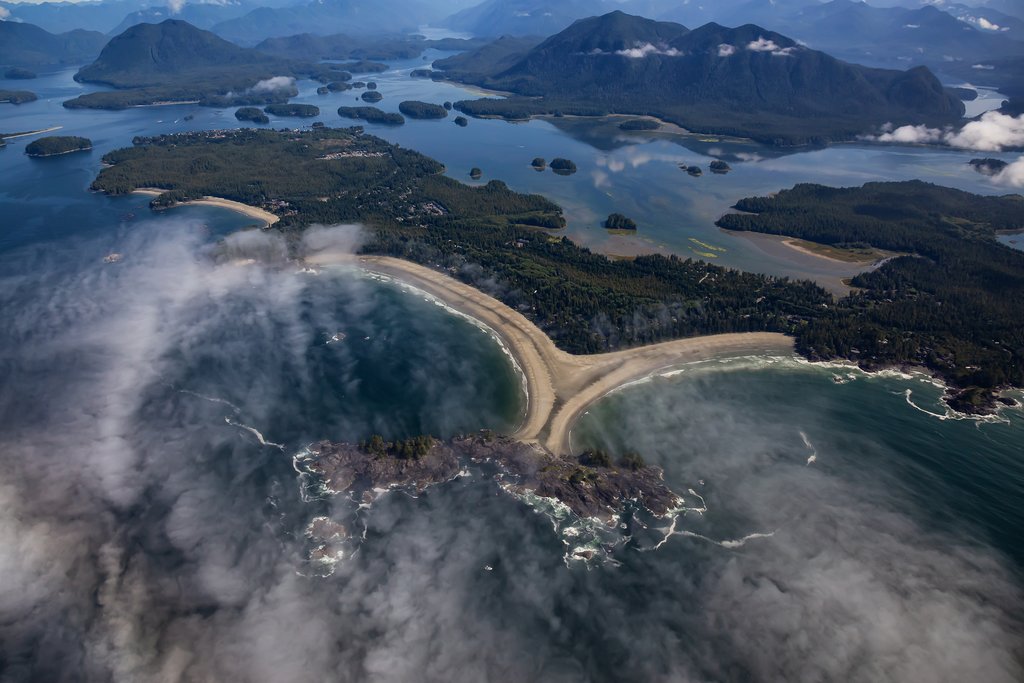
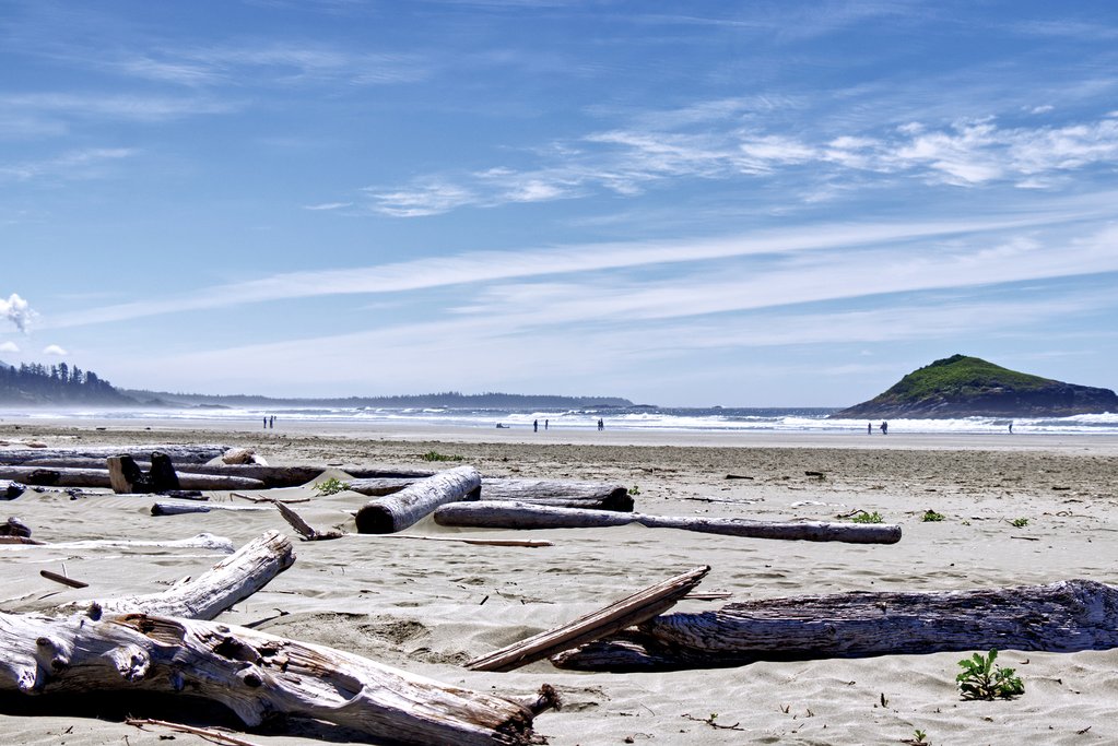
From here, you can either turn left to visit Ucluelet or right to head straight to Tofino (Ucluelet is about 10 minutes down the road and is a quieter, smaller version of Tofino). Nearby, stop at the Kwisitis Visitor Center (overlooking Wickaninnish Beach) for an introduction to the area's natural history and First Nations heritage. If there's time, take a walk along the sandy shore of Long Beach, a 7-mile (11 km) narrow expanse of beach that dominates the landscape before continuing up to Tofino.
With its laid-back vibe, Tofino is one of the top places to visit on Vancouver Island and a popular haven for surfers, families, and city-escaping Vancouverites, The town sits at the end of the long and narrow Esowista Peninsula on sheltered Clayoquot Sound and has a wide range of great restaurants and outdoor activities, such as whale and bear watching, sea kayaking, and coastal hikes. Even in peak tourist season, you can find your own stretch of coastline to explore, from Long Beach, Halfmoon Bay, Florencia Bay to Chesterman Beach, which is famous for its sunsets.
Driving time (Comox to Tofino): 3 hours (143 miles / 230 km)
Day 11: Explore Pacific Rim National Park
Pack your hiking boots (and beach gear) for a full-day if exploring the Pacific Rim National Park Reserve. Drive south on Highway 4 to Ucluelet, a small town on the northern edge of Barkley Sound that offers all of the same pursuits as in Tofino, but on a quieter scale. Rent a kayak and paddle the distance to a few of the wave-whipped islands (there are a hundred) of the Broken Island Group, where you can come ashore and hike the picturesque islands. Best to book a tour if you're not an experienced kayaker.
Sticking to firm ground, you can choose from a variety of trails found along the Long Beach area of the park. Opt first for the 1.6-mile (2.6-km) Lighthouse Loop that starts from He-tin-kis Park south of Ucluelet. Traveling back up the coast toward Tofino, try a couple of other routes: the 3-mile (5 km) Nuu-chah-nulth Trail, a historical loop that opens up to the beach; one of the two half-mile (1 km) Rainforest trails that offer views of towering western red cedar and hemlock, birds, streams, and massive ferns; or the Combers Trail, where a short walk leads to a shell- and driftwood-strewn expanse of beach—great to explore at low tide.
Day 12: Pacific Rim to Victoria (4 h 45 min)

Say farewell to the Pacific Rim and head back across the island along the Pacific Coast Highway to Nanaimo, stopping at any of the places you missed on your way in or for a walk on the beach in Qualicum Beach.
Stop for lunch in the Old City Quarter of Nanaimo, a heritage neighborhood with some great local restaurants (and home to the Nanaimo bar). Farther south, there's Cowichan Bay, a popular stop featuring a colorful string of wooden buildings that overlook a mountain-framed ocean inlet.
The elegant provincial capital of Victoria rests at the southern tip of Vancouver Island. A small city of 380,000, Victoria has retained elements of its British heritage, from double-decker buses and high tea to formal gardens (its top attraction is the world-renowned Butchart Gardens). Find your way on foot to the Inner Harbor, a busy waterway surrounded by the city's top sights and best restaurants, and the perfect spot to begin exploring the city. Be sure to visit the harbor at night when the Empress Hotel and the parliament buildings are lit up by thousands of lights.
Driving time (Tofino to Victoria): 4 hours, 45 minutes (196 miles / 316 km)
Day 13: Victoria to Vancouver, Depart (2 h 30 min)

Leaving Victoria behind, head north to the Saanich Peninsula to Swartz Bay Ferry Terminal for the 90-minute ferry back to the mainland. Arriving at Tsawwassen Ferry Terminal, you'll head straight to Vancouver International Airport.
Driving time (Victoria to Swartz Bay): 45 minutes (20 miles / 32 km)
Ferry time (Swartz Bay to Tsawwassen): 1 hour, 15 minutes
Driving time (Tsawwassen to Vancouver International Airport): 30 minutes (20 miles / 30 km)