
Highlights
- Relax in the crystal clear waters of Shasta Lake
- Explore the many waterfalls in the Cascade Range
- Feast your eyes on Lassen's blackened lava fields and cinder cones
- Taste the amazing wines of Napa
Brief Itinerary
| Day | Highlights | Overnight |
|---|---|---|
| Day 1 | San Francisco to Redding - via Sacramento | Redding, California |
| Day 2 | Explore Lake Shasta - Onto Mount Shasta | Mt. Shasta, California |
| Day 3 | Exploring Mt. Shasta and Surroundings | Mt. Shasta, California |
| Day 4 | Chasing Waterfalls | Burney, California |
| Day 5 | Northern Lassen National Park: Subway Lava Cave & Cinder Cone Hike | Lassen Volcanic National Park |
| Day 6 | Explore Lassen Volcanic National Park | Redding, California |
| Day 7 | Redding to San Francisco, via Napa Wineries |
Detailed Itinerary
Day 1: San Francisco to Redding - via Sacramento

Head out on a journey today, driving north toward Redding. There are not a lot of scenic stops along the way. However, if you have some time, Sacramento makes a nice detour, and only adds around 30 minutes extra driving time to the route. While there, you can make a visit to the Old Town to soak up some gold history.
This storied town was built almost overnight when veins of gold were discovered in the Sierra Foothills in 1849. A massive tide of humankind, all intent on finding their fortune, raced to the Gold Country. Sailing as close as they could get to the gold via waterways, they pulled anchor at San Francisco Bay and sailed east on the Sacramento River. The gold-hungry prospectors were forced to pull up at the confluence of the American and Sacramento Rivers. At this spot, Sacramento was born, with many buildings constructed out of leftover ship timbers and sails.
As you walk through Old Sacramento (now a preserved National Historic Landmark), you can get a sense of the raucous early years. Take your time to stroll through the cobblestone streets and restored buildings. Spend some time in the excellent museums, including the Sacramento History Museum which displays Gold Rush artifacts and offers underground tours and ghost tours of the historic district.
Grab some lunch in the Old Town, or inside the restored paddlewheel boat - the Delta King.
From Sacramento, it's just a 2.5 hr (162 miles) drive to Redding. Once in Redding, it's time to head to your hotel for a bit of R&R. In Redding, you have a huge choice of restaurants, for a great river view, try View 202. Modern decor, with floor to ceiling windows and a huge deck- it is the perfect place to relax after a long driving day!
Day 2: Explore Lake Shasta - On to Mount Shasta

Shasta Lake, located just 15 miles north of Redding, is the state's largest reservoir. It has 370 miles of shoreline and five major lake arms, each with its own distinct character. There is much to explore on the lake, but your destination today is a paddle up the McCloud arm.
On your way to Lake Shasta, stop by the Heritage Roasting Company, a small non-profit coffee roaster/cafe that has a friendly small-town feel and amazing coffee. Grab breakfast and a sandwich for your lunch later in the day, maybe with one of their amazing brownies for dessert?
Pick up your kayak from Holiday Harbor in the morning, and head out onto the McCloud arm of the river. This arm is famous for the grey rocks that rise out of the water. These rocks were formed from ocean sediments many millions of years ago. They make a beautiful picture against the blue-green water of the lake. Paddling can be hot work, so feel free to jump into the lake at any point to cool off. Whenever you are hungry, there are plenty of nice coves to pull out of the river, have a picnic lunch, and enjoy a spot of sunbathing. There is no rush to get anywhere today. It is just a day to enjoy the peaceful water, beautiful scenery and fresh air.
Whenever you are ready, paddle back and drop your kayaks back at the marina. Your last stop of the day is to visit the Lake Shasta Caverns. Thought to have formed roughly 250 million years ago, a tour through the caves provides a fascinating view of beautiful stalactite and stalagmite formations. Also, the caverns are at a constant 58 degrees Fahrenheit, no matter the temperature outside, so it is a great way to escape the heat in summer.
After the tour, it's time to head to your hotel in Mt. Shasta. For dinner, try Cafe Maddalena, an elegant Mediterranean restaurant with a small garden for outdoor dining during the summer.
Day 3: Exploring Mt. Shasta and Surroundings

There is so much to explore in the Mt. Shasta region that you could spend a month here and not repeat any of the hikes. However, with more limited time, here are a few ideas for you to get fully immersed in the area's natural beauty.
Stop by The Oven Bakery before your hike. They serve Northbound Coffee, locally roasted in Mount Shasta. They also have some mouth-watering pastries and bread and are great for breakfast, as well as for picking up supplies for lunch on the hike.
Best View of Mt. Shasta - Climb Yellow Butte
Distance: 3 miles
Elevation gain: 600 ft
Trail type: Out and back
One of the least visited areas in the Mount Shasta region, Yellow Butte is a hidden gem in a valley of great hikes. With very few visitors climbing the butte, you have an opportunity for one of the best views of Mount Shasta and the Shasta Valley, unfettered by other hikers and the pitfalls of well-traveled paths. To the north, the valley stretches to the Oregon border, to the south lies the gorgeous Mount Shasta, to the west you'll see the Trinity Divide and the Mount Eddy range, and to the east, you'll find the northern regions of the Cascades and Sheep Rock. This short climb is very well worth the time and effort. A sunset hike would be ideal, as it is a bit cooler and will offer an amazing backdrop for the big event. You'll find eye candy on the way up as well- wildflowers abound as you climb the old forest road.
While you are here, you can take a small detour to visit Pluto's Cave. These are a set of little known and little-traveled lava tubes. These tubes were formed 190,000 years ago as Mount Shasta was erupting. The caves stretch nearly two miles into the final section if you are brave enough and have the proper footwear and light. Please be aware, there is no exit, so you will have to work your way back out as you came in. There are species of bats that inhabit this area, so make sure not to disturb them as you venture through the caves!
Hiking Mt. Shasta - Avalanche Gulch Trail
Distance: 4.5 miles - 6.5 miles
Elevation gain: 1000 ft - 3500 ft
Trail type: Out and back
Ascending Mt. Shasta can't really be done on a day hike, but for those that want to get up close to the volcano, the Avalanche Gulch hike is a good place to start. The trailhead is 11 miles up the Everitt Memorial Hwy, and the first part of the trail up Avalanche Gulch is called Bunny Flat. At the trail parking, you will see a healthy mix of day hikers and mountaineers all getting ready to hike up the volcano. The trail ascends the south side of the mount through open conifer forests to the Sierra Club Hut at Horse Camp. From the trailhead to Horse Camp and back is 4.5 miles, so this is probably a good distance to tackle if you have kids. The next section will get much harder.
Those that are still energized can tackle the next leg, from Horse Camp to Lake Helen. Journeying to Lake Helen adds another 3 miles (round trip) to your hike, and another 2,500 feet of elevation gain. Most of the year, you will encounter snow on this leg of the trail, so please be prepared for this. Follow the footsteps of other hikers that lead the way through the winding gulch. It is uphill every step of the way, but don't forget to look back! With every step, the view down gets more impressive. It will be pretty obvious when you reach Lake Helen, as you reach an expansive flat area on your right. The lake is frozen most of the year. If you are lucky, and you arrive at the end of summer, you might glimpse some glacier green water. Here, you will meet friendly forest rangers, checking permits and answering questions. Enjoy some well-earned rest before heading back down the mountain.
Best Waterfall Hike - Faery Falls (Good for Kids)
Distance: 1.5 miles round-trip
Elevation gain: 300 feet
Trail type: Out and back
Nestled in Ney Springs Canyon is the hidden Faery Falls. The 1.5 mile round-trip hike to the falls will lead you through the old Ney Springs Resort and up the beautiful canyon surrounded by evergreens and crag outcroppings.
The hike itself begins at the bottom of an old road. After half a mile of walking, you will come to the abandoned Ney Springs resort. The resort was popular in the late 1800s as a spot for visitors to take the mineral waters. Very little of the resort remains today. If you are curious, take a walk by the old pools. The water in the pool is extremely slick and still bubbles up from below.
As you continue up the single track road from the resort for about a quarter mile, you will come upon a trail heading down towards the creek. The trail will take you to a nice viewing area right in front of and above the falls. From there, you can work your way down to the bottom. This makes a truly refreshing late summer or early fall hike due to the mist from the falls.
Best Views of Glacier Lakes - Castle Lake & Heart Lake (Good for Kids)
Distance: 2.6 miles - 3.6 miles
Elevation gain: 400 ft - 900 ft
Trail type: Out and back
Starting from the Castle Lake Picnic Area, the trail is self-explanatory. The first half mile is the toughest on the legs, as it is more vertical, but it is by no means strenuous. This part of the trail itself is rather soft until you level out and reach the saddle at 0.6 miles. From there, the trail can get confusing, as it seems to cobweb up the mountainside in various (wrong) directions. Do not hike directly to the overlook, as you will end up bushwhacking your way out. Instead, keep left as the trail will take you to the easternmost side of Heart Lake.
On the hike up, you will get views of Castle Lake and see Castle Peak in view. Soon, you will be able to spot Heart Lake through a cluster of pines. The trail comes down to the shore at a point between the two coves that make up this heart-shaped lake. The trail precedes around the north end of the lake to a fantastic viewpoint. Look out over a ledge and down at Castle Lake and the green pine-covered valley. Black Butte and Mount Shasta rise prominently beyond.
From here, continue west along the ridge. The beginning of the overlook is only 0.3 miles away after leaving Heart Lake. After passing through a small meadow, you will reach a narrow trail that climbs through some brush before reaching the small cliffside clearing. Follow the trail to the peak of the overlook, with a fantastic 360-degree view.
While the trail is short, this trip makes an excellent all-day trip in the summer. First, spend some time swimming and picnicking on Castle Lake and start the hike in the mid-afternoon. Take some time to take a dip in Heart Lake along the way, as the shallow waters warm nicely during the summer months. Try to time your visit to the overlook so that you arrive around dusk and catch the sunset. The trail is short and easy enough to risk a descent after sunset.
For dinner, visit the Highland House in the Mt. Shasta Resort for a special meal. Ask for a table near the window for a magnificent view of Mt. Shasta as you enjoy your food.
Day 4: Chasing Waterfalls

The road connecting Mt. Shasta to Lassen is filled with some of the most beautiful waterfalls in the country. You will be forgiven if you think you've been transported to somewhere in South America... ... But, before you leave town, stop by the local favorite Mount Shasta Pastry for some breakfast and coffee. It's a small cafe, so be sure to arrive early, especially on the weekends as it fills up quickly.
Your first stop today is the McCloud River and the three falls here, just outside the town of McCloud and 20 minutes from the town of Mt. Shasta. The Three Falls Trail is a great hike through a mountainous, high desert forest with a wonderful variety of flora along the trail, including redwoods, Douglas fir, orange honeysuckle, and thimbleberry.
In the summer, the 12-foot tall Lower Falls and its downstream pool is very popular with swimmers. Rock formations above the pool make for a fun cliff jumping spot. Head up the trail, past the crowds at the Lower Falls, to discover the far more impressive and scenic Middle and Upper Falls.
If you are pressed for time, you can also enjoy the three falls from the road, as there are overlooks for each of the falls along the way. However, we would recommend to take your time, and hike the three falls, and follow the hike up with a picnic lunch by the lower falls and some swimming.
Distance: 5.3 miles
Elevation: 350 ft
The day of waterfall exploration continues with a visit to McArthur-Burney Memorial Falls State Park. The park's centerpiece is the 129-foot Burney Falls, which is not the highest or largest waterfall in the state, but is possibly the most beautiful. Teddy Roosevelt called Burney Falls the "eighth wonder of the world." It does have to be seen to be believed. The water from the creek falls over the cliff edge, and an underground river that flows below the creek at the top also feeds the waterfall. This is what makes the falls so special, as you see water coming out of a dozen holes right in the middle of the waterfall. Great views of the falls are accessible right from the parking lot. However, for a more refreshing perspective, take the trail to the pool at the base of the falls and along the stream (1.3 miles).
The stream from the waterfall flows to Lake Britton, which is worth a stop if you have time. The 4,700-square-mile reservoir is an ideal spot for boating, kayaking, and fishing. The site also offers great wildlife watching—look for bald eagles, river otters, osprey, and some very large trout. Kayak into Burney Creek or over to the PG&E Britton dam. If you don't have your own boat, the Lake Britton Marina rents canoes, rowboats, kayaks, and small motorboats as well as boat slips.
Head to your hotel after exploring Lake Britton. For dinner, consider The Rex Club in Burney, best described as gourmet food in a rustic atmosphere. Don't let it's modest exterior deceive you. You will enter into a warm country-style interior with friendly service and great food.
Day 5: Northern Lassen National Park: Subway Lava Cave & Cinder Cone Hike

Start the morning in with a hearty breakfast at BlackBerry Cafe in Burney. If you are especially hungry, try their famous "Mountain Man" breakfast with everything!!
After breakfast, you start your exploration of Lassen Volcanic National Park, and the fascinating changes in the landscape caused by geothermal activity. The first stop of the day is just outside of the park, called the Subway Lava Cave. This self-guided trail is inside an underground lava tube. It's pitch black inside and the floor is rough and jagged, so don't forget to bring a flashlight and a pair of sturdy shoes. A jacket is recommended as well, as the cave remains a cool 46 degrees Fahrenheit all year round.
Distance: 1/3 mile
Elevation gain: none
From the lava cave, we head into Lassen Volcano National Park proper. This northern section of the park is less visited but has some of the most interesting volcanic landscapes of the whole park. One of the highlights is the remains of a Cinder Cone volcano, aptly named Cinder Cone. A 4.8-mile round-trip trail allows you to experience the wonder of Cinder Cone Volcano first hand. This kind of volcano is formed when gas-charged lava is violently ejected high in the air from a single vent. The lava is blown apart into small bits that solidify in the air, and fall back to earth as cinders called scoria, forming a circular or oval cone as they accumulate.
From the Butte Lake parking area follow the relatively flat trail bordered by woodlands on the right. The trail gets steeper as Cinder Cone comes into view. At 1.2 miles, the trail reaches a fork at the base of Cinder Cone. Look to your left here for the first views of the colorful Painted Dunes. Be sure to take a break in the shade of the surrounding Jeffrey Pines before following the trail to the left and beginning the heart-pumping climb to the top of the cone. As the trail slowly circles around to the south side of the cone, Lassen Peak comes into view. The trail then continues to the top where climbers are rewarded with views in all directions. Prospect Peak, Lassen Peak, Snag Lake, the Fantastic Lava Beds, and the Painted Dunes are all clearly visible. A separate trail continues down into the crater of Cinder Cone.
This hike is best done at the start or end of the day because there is no shade to be had as you start the climb on Cinder Cone. Also, at the end of the day, the sunset creates a beautiful glow over the crater of the Cinder Cone and the Painted Dunes.
Distance: 4.8 miles
Elevation gain: 1,043 ft
Trail type: Loop
From here, head to your accommodation inside or near the park, as you will continue exploring tomorrow.
Day 6: Explore Lassen Volcanic National Park

Today, you will be exploring the central section of Lassen Volcanic National Park. The recommended stops for today give you a taste of the different aspects of the park, from serene alpine lakes to active fumaroles, and from smoking mud pots to jagged mountain peaks. Please be aware that many of the hikes recommended in this central area are at a high elevation, and may still be snow-packed in early summer. The average opening date is around July 4th, but it depends on the year, so it is essential to check with the national park service before you travel.
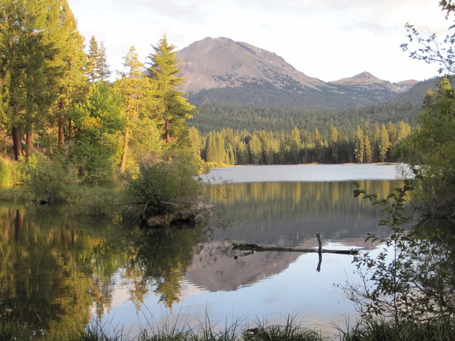
The first stop of the day is the serene Manzanita Lake. Visiting the lake early in the morning gives you a better chance to capture the still reflection of Lassen Peak in the lake. Take a walk around the lake as far as you like- there are plenty of opportunities to catch glimpses of wildlife here, from deer to woodpeckers. You can also visit Loomis Museum to learn more about the park. Before you leave the area, head to the Manzanita store for a late breakfast, some coffee and to pick up some picnic supplies for lunch, as there are not many food options in the park.
The next stop on your list is Lassen Peak, for which the park is named. Park at the trailhead for Lassen Peak. You won't have time to climb the peak today. However, at the trailhead, there are some good displays that show what the area looked like right after the volcanic eruption, and how the landscape has recovered over the years. This is a good source to learn a bit more about the geology of the park.
Just down the road from Lassen Peak is Bumpass Hell. The trailhead for Bumpass Hell is near Lake Helen. You can take a short walk near Lake Helen before heading onto the trail. Bumpass Hell contains the largest and most interesting hydrothermal area in the park. With its hot springs, steaming fumaroles, and boiling mud pots, its like walking around in a geology textbook (but much cooler)! The hike into Bumpass Hell is an easy 3 miles round trip. You can access the area safely on a boardwalk, and it’s forbidden (and very dangerous) to leave the trail and walk elsewhere in hydrothermal areas. You don’t want to earn yourself a boiled foot as a souvenir from the hot springs...so stay on the boardwalk.
Your final hike for the day is to the Terrace, Shadow and Cliff Lakes. This trail is a photographer's dream - three crystal clear lakes with contrasting colors situated one after another! The trail is 4 miles round-trip, with a moderate amount of elevation gain (750 ft). The first mile is the most challenging, and after that, it's a gradual incline to the lakes. All three lakes are swimmable, but depending on when you visit, it might be too cold to take a dip.
From here, it's time to head to your hotel for a bit of R&R. For dinner tonight, you could splurge with a visit to Clearie's. This high-end eatery is a local favorite for its friendly and cozy atmosphere, as well as amazing cocktails - did someone say smokin' martinis? It will be the perfect end to the perfect day.
Day 7: Redding to San Francisco, via Napa Wineries

It's your last day today, and you are heading back to San Francisco. Enjoy the last morning in Redding and grab a quick coffee and breakfast at Evergreen Coffee before heading off on your 3.5 hr (219 miles) drive back to San Francisco.
The drive from Redding to Napa is around (3 hours), you want to head out early so that you have time for a stopover in Napa along the way.
Before you head out to the wineries, head to a leisurely lunch first in St. Helena. One favorite is the Farmstead at Long Meadow Ranch for its farm-to-table restaurant. Farmstead offers delicious food sourced from responsible farms. For more upscale fare, try The Grill at Meadowood. Lunch at Meadowood stands out for its fresh seasonal ingredients and has a great wine list to match.
Your first winery stop for today is Louis M. Martini Winery in St. Helena. Founded in 1933, this was one of the first Napa Valley wineries to open after the repeal of Prohibition. True to Napa's reputation for creating the best Cabernet Sauvignons, Martini offers an acclaimed portfolio of these spectacular reds. The winery and grounds have been magnificently restored offering both indoor and outdoor tastings. (Tastings start at $30 pp).
Your second stop is Artesa Vineyard and Winery, one of the most extraordinary wineries in the valley. You will drive along a back-country road lined with fields of wildflowers up a hill. The road stretches on, dramatically leading up to what appears to be a castle atop the hill. The winery structure, an architectural wonder, is built into the side of the hill, with reflecting pools and sculptures. There are a number of daily tours available to try the wines on offer, and you can choose one that will work best for your schedule and party. On the weekends, you can opt for the truly special treat of a Vino con Queso pairing, and enjoy artisan cheeses paired with reserve wines. (Tastings start at $10 pp). This winery is notable for it's world-class Pinot Noir and Chardonnay.
Your final stop today is Domaine Carneros, known for its award-winning sparkling wines and Pinot Noir. Housed in an eye-catching 18th-century-inspired chateau, this winery is impossible to miss. Gaze out at the rolling hills and gorgeous vineyards as you sip the bubbles from your patio table. (Tastings start from $35 pp). Take your time as this is the last winery stop of the day, and Domaine Carneros is also one of the last wineries to close their tasting rooms.
Make your way home as the sun sets and casts the Golden Gate bridge in a red glow. A picture-perfect ending to your road-trip!
Looking for more California road trip ideas? Check out kimkim's top 5 road trips in Northern California.
Map
