

Highlights
- Ride Guatemala's best cycling trails led by expert guides
- Tour colonial Antigua, a UNESCO World Heritage Site
- Visit beautiful Lake Atitlán and its three dormant volcanoes
- Cycle the Cuchumatanes Mountains, in the heart of coffee country
Brief Itinerary
| Day | Highlights | Overnight |
|---|---|---|
| Day 1 | Arrive in Antigua | Antigua |
| Day 2 | Antigua Walking Tour & Bike Prep | Antigua |
| Day 3 | El Zur Mountain Bike Park | Antigua |
| Day 4 | Tecpán to Lake Atitlán Backcountry Mountain Bike Ride | Panajachel |
| Day 5 | Lake Atitlán to Slickrock Mountain Bike Ride | Lake Atitlán |
| Day 6 | Lake Atitlán Free Morning, Transfer to Huehuetenango | Huehuetenango |
| Day 7 | Climb the Cuchumatanes & Descend to Todos Santos | Todos Santos Cuchumatan |
| Day 8 | Cross-Country Ride: Todos Santos to Laguna Magdalena | Laguna Magdalena |
| Day 9 | Cross-Country Ride: Laguna Magdalena to Acul | Acul |
| Day 10 | Cross-Country Ride: Acul to Uspantan | Uspantan |
| Day 11 | Cross-Country Ride: Uspantan to Cobán | Cobán |
| Day 12 | Backroads Ride from Cobán to Semuc Champey | Lanquín |
| Day 13 | Transfer from Lanquín to Antigua | Antigua |
| Day 14 | Antigua to Guatemala City, Depart |
Detailed Itinerary
Day 1: Arrive in Antigua

Welcome to Guatemala! A personal driver will be waiting for you at the airport in Guatemala City to transfer you about 1 hour west to the colonial city of Antigua. After settling into your hotel, you'll have free time to explore on your own.
Once the capital of Guatemala, Antigua is known for the Spanish colonial Old Town around its main plaza, Parque Central. It's also surrounded by three volcanoes, and the contrast between these imposing mountains and the city's colorful architecture is part of the reason Antigua has earned UNESCO World Heritage Status.
Spend the remainder of the day walking Antigua's cobbled streets and enjoying local cuisine at cafes, or head to the food markets for quick eats like tostadas and empanadas (called dobladas in Guatemala). Tomorrow you'll explore the city on a more in-depth guided tour, so for now simply hit a few of the main attractions. These include the Santa Catalina Arch and the ruins of the 16th-century Antigua Guatemala Cathedral and 18th-century Convento Santa Clara.
Day 2: Antigua Walking Tour & Bike Prep

In the morning, meet your local guide (who's also an expert historian) to explore Antigua. Guatemala's former capital boasts an impressive array of Baroque buildings and colonial homes painted in bright pastels. Many old religious and civic structures have been beautifully renovated after major earthquakes while others retain a tumbledown charm.
On this three-hour tour, you'll visit 18th-century landmarks like the Palacio del Ayuntamiento (City Hall Palace), which houses the town offices and a museum of ancient books; the Palace of the Captain's General, home to the headquarters of the Guatemala Institute of Tourism; the Casa Santo Domingo, a former convent that is now a hotel and museum; and La Merced Church, whose canary yellow Baroque facade is a hallmark of the city.
After the tour, you'll have time to grab lunch before heading to the local cycling shop to prep your bike. There's a full staff here ready to help you get your bike in shape for the next two weeks of riding.
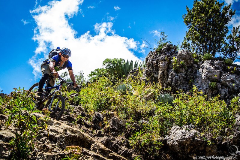
Day 3: El Zur Mountain Bike Park

Today kicks off your first great ride in Guatemala—and what a route it is! In the morning you'll transfer up into the mountains above Antigua by 4WD shuttle to a trail network sitting at 8,500 feet (25,90 m). Then hop on your bike and head out on a one-of-a-kind trail down through the beautiful El Zur private nature reserve. Located on the southern side of the Agua volcano, this purpose-built route covers 12 miles (19 km) of flowy, rolling, single-track bliss.
Have a blast as you race down mountain switchbacks while enjoying the incredible scenery. Along the way, you'll pass through lush forests and see awesome viewpoints, so keep your camera handy. At the bottom, enjoy a snack and refreshments before catching the shuttle back to Antigua.
Distance: 12 miles (19 km)
Ascent: 2,300 feet (700 m)
Descent: 3,380 feet (1,030 m)
Day 4: Tecpán to Lake Atitlán Backcountry Ride

Transfer from Antigua to the mountain town of Tecpán to start today's ride. This epic backcountry adventure celebrates a little bit of everything. A gradual dirt road climbs out of Tecpán, quickly turns to a mountain trail, and winds its way through pine-forested mountains. Know that there are various trail drops and a couple of tough, steep climbs.
The ride takes you through a rural Maya settlement before dropping on a steep descent along the famous Sendero de las Vacas (Trail of the Cows). A 2.5-mile (4 km) climb brings you to a stunning viewpoint above Lake Atitlán, where you'll have lunch and admire the views. Afterward, follow the contouring Santa Cat trail to the colorful Santa Catarina Palopó staircase run. Finish the ride in Panajachel, on Atitlán's north shore. Here you'll have the evening free to enjoy the town's nightlife.
Distance: 23 miles (37 km)
Ascent: 3,235 feet (986 m)
Descent: 5,092 feet (1,552 m)
Day 5: Lake Atitlán to Slickrock Ride

Enjoy a hearty breakfast at the hotel and then hop in a shuttle for a transfer back up the mountain to the town of Las Trampas. Upon arrival at the trailhead of Slickrock, you'll embark on a point-to-point ride that will take you to a rest stop. Then it's a few miles of climbing on a mix of single-track, Jeep track, and dirt road to the highest point on the route at 9,842 feet (3,000 m).
From there, the trail drops fast and stays steep to the upper Madre Vieja river valley. Work your way along the lush valley floor to your next long climb, a rough jeep-track ascent to a waiting support vehicle. After lunch, finish the descent into town on a stretch of tight, steep trail with switchbacks leading to the road just above Panajachel and the lake.
Distance: 13 miles (21 km)
Ascent: 1,673 feet (510 m)
Descent: 4,823 feet (1,470 m)
Chat with a local specialist who can help organize your trip.
Day 6: Lake Atitlán Free Morning, Transfer to Huehuetenango

Enjoy a leisurely breakfast and a tranquil morning at your hotel. Maybe take a swim or head out on the lake for a brief kayak trip. Alternatively, you may wish to relax in a hammock or soak in a hot tub above the sparkling blue Lake Atitlán. Either way, it's a good opportunity to give your body a rest and gather your second wind. You're going to need the energy in the days ahead.
At midday, take the boat back to Panajachel for lunch before setting off for the Cuchumatanes, a rugged mountain range home to the highest non-volcanic peaks in Central America. Your destination is the city of Huehuetenango, which sits at an altitude of 6,233 feet (1,900 m). Know that the surrounding mountains, while vast and beautiful, are incredibly steep. This area sees very few foreign visitors, and even fewer mountain bikers have explored its trails. This is as "off the beaten track" as it gets.
Upon arrival in Huehuetenango, you'll check in to a hotel near the main square. In the late afternoon, you'll have time time to take a stroll and buy any items you might need. You can also stop at the local bike shop to make any necessary repairs or purchase more gear.
Day 7: Climb the Cuchumatanes & Descend to Todos Santos
Leave Huehuetenango early and arrive at your first major ascent. Here the road switchbacks upwards for 6 miles (9 km) with a gain in elevation of 3,281 feet (1,000 m). It's a hard ascent, but it's filled with breathtaking views of the spine of the Cuchumatanes as you pass through small indigenous villages. These little communities offer insight into the culture and way of life of the rural Guatemalan people. Near the top of the climb is a scenic lookout with sweeping views all the way back to Antigua.
Further along, you'll ride on old Jeep tracks and single-track trails as you make your way across the plateau. From here, enjoy an excellent single-track descent that drops down into the mountain village of Todos Santos Cuchumatán. The Indigenous residents of this pueblo still practice traditional customs and adhere to Maya culture. Upon arrival, head to your base for the night: a family-run guesthouse in the center of the town.
Distance: 27 miles (44 km)
Ascent: 2,300 feet (5,900 m)
Descent: 4,180 feet (1,275 m)
Day 8: Cross-Country Ride: Todos Santos to Laguna Magdalena

The gorgeous landscapes on this leg of the ride include rocky peaks, coniferous forests, stretches of arid soil, and fertile valleys with pastureland home to flocks of sheep. That said, it's a tough day as you tackle a rocky ascent on dirt tracks back to the plateau. Then follow sheep tracks and dirt roads that pass through humble pueblos to the edge of the main ridge of the Cuchumatanes. Here you'll enjoy an exhilarating descent followed by lunch.
You'll overnight at the cabins of a community development project at Laguna Magdalena, near the village of Chancol, and experience firsthand how the locals live. You'll even enjoy a homemade dinner prepared by the villagers.
Distance: 26 miles (42 km)
Ascent: 4,920 feet (1,500 m)
Descent: 3,200 feet (975 m)
Day 9: Cross-Country Ride: Laguna Magdalena to Acul

Today you'll embark on a ride to the Ixil Community, a triangle of three neighboring towns in the western highlands of Guatemala. The route follows a loop around the north side of a deep ravine separating the departments of Huehuetenango and Quiché. It's fun dirt-trail riding as you cycle across the mixed terrain of the Cuchumatanes high plateau. It's also a real cross-country adventure, one that runs through pinewoods and abounds with breathtaking mountain scenery.
At the northern end of the ride, there is a technical, often muddy descent to a remote village. From there, follow dirt roads to a river valley and continue onward for a fairly long climb then down to another river. Your destination is the village of Acul, which is known for cheesemaking and is the only dairy-producing zone in the region. You'll spend the night in a rustic, family-run hotel and for fun can even visit a local cheese factory.
Distance: 36 miles (57 km)
Ascent: 3,930 feet (1,200 m)
Descent: 8,200 feet (2500 m)
Day 10: Cross-Country Ride: Acul to Uspantan

Start today's long ride on an old highway that climbs steadily out of the Nebaj Valley. From Acul, ride down to the road and follow an undulating track to Nebaj, the main town of the Ixil Community. Then pick up an old Maya highway, known as the Boqueron, and follow it up into the mountains on a route that offers sweeping views of the western highlands.
Continue around a high peak and admire more great views of the Tajumulco volcano before dropping down into a village. Here you'll meet a waiting support vehicle, regroup, and enjoy lunch in the town of Cunén. Venture on to the second major set of climbs, which takes you up high ridges and past pine forests and K'iche' Maya villages to reach the town of Uspantan, home of 1992 Nobel Peace Prize winner and human rights activist Rigoberta Menchú.
Distance: 37 miles (58 km)
Ascent: 5,900 feet (1,800 m)
Descent: 6,400 feet (1,950 m)
Day 11: Cross-Country Ride: Uspantan to Cobán

Start the morning with a rolling ride on a paved surface past the town of Chicamán. Follow this to a long, gradual, 6-mile (9 km) ascent on a dirt road that leads to the hills above the Río Chixoy. Then enjoy a fast descent on a trail with some technical sections to the village of Ojo de Agua. Thus begins a rougher bit of single-track that takes you down to the river. After crossing a bridge, you'll start a series of long climbs that will take you through the rest of the day and covers 17 miles (27 km).
Reunite with the support vehicle in the town of Santa Cruz la Laguna, where you'll transfer to the city of Cobán. The Cobán region is home to some of Guatemala's densest cloud forests and is famous for coffee production. Also, it's one of the few remaining places where it's possible to spot the resplendent quetzal—Guatemala's rare national bird. You'll overnight at a hotel in nearby San Pedro Carchá.
Distance: 38 miles (61 km)
Ascent: 5,250 feet (1,600 m)
Descent: 6,560 feet (2,000 m)
Day 12: Backroads Ride from Cobán to Semuc Champey

Your final day of riding takes you to the turquoise waters of Semuc Champey, an area of outstanding natural beauty known for its terraced pools of pristine river water. It's one of the best places in the entire country for a swim.
The first 31-mile (50 km) section of today's ride follows a straightforward and undulating road with excellent views. Then you'll descend on a rough limestone path to the riverside town of Lanquín. Here you'll tackle the main challenge of the day: a steep 2-mile (3 km) climb to a ridge followed by a bumpy, Jeep-track descent to Semuc Champey. Once there, however, you can spend the afternoon relaxing and swimming in the pools. Afterward, transfer back to Lanquín, where you'll overnight.
Distance: 43 miles (69 km)
Ascent: 2,625 feet (800 m)
Descent: 5,250 feet (1,600 m)
Day 13: Transfer from Lanquín to Antigua

Get an early start to make it back to Antigua by mid-afternoon. This scenic six-hour drive passes through central Guatemala's highlands, and you'll break up the trip by stopping off for breakfast en route. Back in Antigua, you can indulge in some shopping at the Mercado, the colorful municipal market where vendors sell handcrafted goods, garments, textiles, and a variety of other items. In the evening, perhaps head out to a nice restaurant to celebrate the successful completion of your challenging adventure.
Day 14: Antigua to Guatemala City, Depart

Depending on your departure schedule, enjoy breakfast in Antigua and perhaps a walk around. Then, at the appropriate time, a driver will transfer you back to Guatemala City for your flight home. Adios!
More Guatemala Itineraries
Looking for more inspiration for your trip to Guatemala? Check out these other Guatemala itineraries, explore other ways to spend two weeks in Guatemala, or discover the best time of year to visit Guatemala.
Map
