
Highlights
- Trek up Tajumulco volcano, Central America`s highest peak
- Hike Acatenango and marvel at lava eruptions from nearby peaks
- Visit the colonial town of Antigua, a UNESCO World Heritage site
- Conquer a total of seven volcano summits in the Guatemalan highlands
Brief Itinerary
| Day | Highlights | Overnight |
|---|---|---|
| Day 1 | Arrive in Antigua, Optional Activities | Antigua |
| Day 2 | Hike Pacaya Volcano | Antigua |
| Day 3 | Hike Acatenango Volcano & Camp Overnight | Acatenango Volcano |
| Day 4 | Day Hike to Fuego Volcano & Camp Overnight | Acatenango Volcano |
| Day 5 | Acatenango Sunrise Hike, Transfer to Antigua | Antigua |
| Day 6 | Transfer to Quetzaltenango | Quetzaltenango |
| Day 7 | Hike Zunil Volcano | Zunil Volcano |
| Day 8 | Zunil Hike & Hot Springs | Quetzaltenango |
| Day 9 | Hike Santa Maria Volcano | Quetzaltenango |
| Day 10 | Transfer to Tuichán, Hike Tajumulco Volcano | Tajumulco Volcano |
| Day 11 | Descend Tajumulco & Transfer to Lake Atitlán | San Pedro |
| Day 12 | Hike San Pedro Volcano | San Pedro |
| Day 13 | Lake Atitlán Free Day | San Pedro |
| Day 14 | Iximché Ruins & Transfer to Antigua | Antigua |
| Day 15 | Transfer to Guatemala City & Depart |
Detailed Itinerary
Day 1: Arrive in Antigua, Optional Activities

Welcome to Guatemala! Upon arrival at La Aurora International Airport in Guatemala City, a personal driver will be waiting for you in the terminal holding a sign with your name. You'll then hop in the vehicle and head about an hour west to the well-preserved Spanish colonial city of Antigua.
Once the capital of Guatemala, Antigua is known for the Spanish colonial Old Town around its main plaza, Parque Central. It's also surrounded by three volcanoes, and the contrast between these imposing mountains and the city's colorful architecture is part of the reason Antigua has earned UNESCO World Heritage Status.
Spend the remainder of the day walking Antigua's cobbled streets and enjoying local cuisine at cafés, or head to the food markets for quick eats like rellenitos (fried plantains stuffed with black beans), tostadas, and elotes (grilled corn on the cob). You should also visit a few of the city's main attractions like the Santa Catalina Arch and the ruins of the 16th-century Antigua Guatemala Cathedral and 18th-century Convento Santa Clara.
Day 2: Hike Pacaya Volcano

Leave early in the morning for a guided climb up the 8,370-foot (2,552 m) Pacaya volcano. These slopes are home to some of the most impressive volcanic landscapes in Central America. Set in its own national park, Pacaya is known for the continuous plume of smoke drifting from its summit and the massive dried lava field at the base of its caldera.
The group will meet in Antigua to fill water bottles and prepare for the hike. Then you'll transfer by private vehicle for about 1.5 hours to the park office and trailhead. As your group moves up the mountain, you'll be treated to ever more incredible views. Upon reaching the base of the caldera, your guide will direct the group through the dried lava fields, recently reformed after a massive eruption in 2010.
You'll continue the ascent to the peak. There, you'll stop for a picnic lunch amid sweeping views of nearby volcanoes Agua, Fuego, and Acatenango. You can also visit geothermal hotspots on the cooled lava formations, which are great for roasting marshmallows. The hike down traverses more dried lava fields before descending through tropical forests and farmland. After a walk down to the trailhead, you'll return to Antigua by private vehicle and arrive in town around 4-5 pm.
- Est. hiking time: 3-4 hours
- Distance: 5 miles (8 km)
- Ascent: 1,312 feet (400 m)
- High point: 8,372 feet (2,552 m)
Day 3: Hike Acatenango Volcano & Camp Overnight

This morning you'll meet at the Old Town Outfitters Shop, where you can fill up your water bottles and purchase any additional gear you might need. Be sure to eat breakfast beforehand and pack a small snack for the road. Then you're off on a one-hour drive from Antigua to La Soledad. This mountain village is perched on the slope of Acatenango, the volcano you'll be climbing today.
It begins with a one-hour hike up steep paths through farmland that will allow you to acclimatize to the environment. Know that the trail up Acatenango has four distinct microclimates, each of which will take you about an hour to traverse. The second phase passes through old-growth tropical cloud forest, home to some of the region's oldest trees. After emerging from the forest, you'll glimpse views of the surrounding volcanoes: Atitlán, Tolimán, San Pedro, Santa Maria, Santo Tomas, and Tajumulco). At midday, you'll break for a fresh picnic lunch.
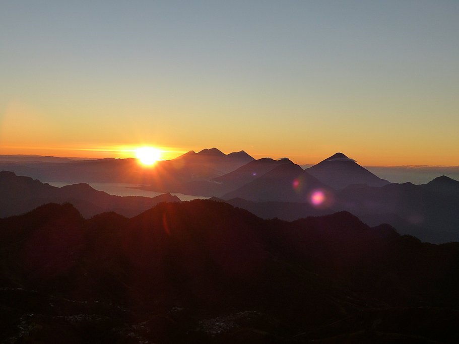
Temperate coniferous and tropical dry forests characterize the third phase of the ascent, which leads to the storm-beaten tree line of the volcano. Your campsite is located just below it and offers sweeping views of the Antigua Valley and Fuego volcano. After setting up camp, you can relax and enjoy the surroundings while your guide prepares a fresh camp dinner at 12,300 feet (3,750 m). Later, you might get lucky and see a spectacle of light and fire from one of Fuego's eruptions.
Hike Details:
- Est. hiking time: 5-6 hours
- Distance: 5 miles (8 km)
- Ascent: 3,600 feet (1,100 m)
- High point: 12,300 feet (3,750 m)
Day 4: Day Hike to Fuego Volcano & Camp Overnight

Enjoy an unforgettable breakfast as you watch the sunrise over the cloud line and gild the peaks of the surrounding volcanoes. Then get back in gear and embark on a one-hour descent to the saddle between the Acatenango and Fuego. After a short rest, continue for 1.5 hours as you wind your way up to the sheer ridge along Fuego, which is situated between the highland valleys and the Pacific slope. Here, you'll take a break for lunch and possibly witness an eruption at close range.
Spend the remainder of the afternoon hiking back to the campsite. Once back at camp, you'll have plenty of time to rest and recharge. After another delicious dinner prepared by your guide, you'll get back in your tent and fall asleep to the sounds of the wind rushing between the mountain peaks.
- Est. hiking time: 3-4 hours
- Distance: 3.4 miles (5.5 km)
- Ascent: 1,080 feet (329 m)
- High point: 11,700 feet (3,565 m)
Day 5: Acatenango Sunrise Hike, Transfer to Antigua

Rise early to see the sunrise over the peaks once more, then embark on a final two-hour ascent up Acatenango. This route is the steepest yet and follows a scree trail dotted with dwarf pine trees and alpine mosses. The reward, however, is that it will take you right to the rocky summit of Acatenango.
Upon reaching the top, you'll rest and enjoy 360-degree views of the Guatemalan highlands all the way to the border with Mexico. After enjoying the views, you'll return to camp for breakfast before beginning the three-hour descent back to La Soledad. This route follows a different trail, so you can enjoy more beautiful scenery as you descend through different microclimates. From La Soledad, you'll transfer back to Antigua and have the rest of the afternoon free.
- Est. hiking time: 2-3 hours
- Distance: 4.5 miles (7 km)
- Ascent: 1,500 feet (475 m)
- High point: 13,000 feet (3,976 m)
Chat with a local specialist who can help organize your trip.
Day 6: Transfer to Quetzaltenango

After breakfast, your driver will take you on a six-hour trip across the high sierra to Quetzaltenango (known by its Maya name of Xela). Traveling along the Pan-American Highway, you'll pass its highest point, known locally as "Alaska." After lunch at a roadside restaurant, you'll arrive in Quetzaltenango by mid-afternoon. Sitting at an altitude of over 7,500 feet (2,335 m), this is Guatemala's second-largest city and the center of the K'iche' Maya people.
Upon arrival, check into your hotel close to the central Parque Centro América. Later you can enjoy dinner at one of the nearby restaurants. However, be sure to get to sleep early, as another great hike is in store tomorrow—this time up Zunil volcano.
Day 7: Hike Zunil Volcano

Early in the morning, leave on a short drive to the trailhead in the village of Xecam. From here, hike two hours up to an altiplano grassland plateau. While gaining approximately 3,200 feet (1,000 m) in elevation, you'll traverse plains full of sheep, villages, and isolated forest. Eventually, you'll arrive at the Siete Cruces ("Seven Crosses") ridge trail. Then enter a forest of pinabete trees (a rare pine endemic to Guatemala) as you wind along the ridge of Zunil volcano and neighboring Santo Tomás volcano.
Break for lunch in one of the many open grass pitches along today’s trail. Then stop for the night just an hour short of Pico Zunil at a beautiful campsite with sensational views east to the Atitlán and Panchoy Valley volcanoes, and west to your next objectives: Santa Maria, Santiaguito, and Tajamulco (Guatemala's highest peak at 13,789 ft/4,203 m).
- Est. hiking time: 5-6 hours
- Distance: 5.5 miles (9 km)
- Ascent: 2,360 feet (720 m)
- High point: 11,620 feet (3,542 m)
Day 8: Zunil Hike & Hot Springs

Enjoy an early camp breakfast, then continue following the Siete Cruces trail as you climb the ridge to the summit of Zunil. After enjoying the views at the top, you'll descend through the cloud and bamboo forests of the Zunil Valley to the natural hot springs of Fuentes Georginas.
Depending on the weather, there will be two route options. One is steep and leads directly to the springs, while the other is less direct. Regardless of the route your guide decides on, you should arrive at the hot springs by midday. Then enjoy a well-deserved rest and soak in the thermal pools. After lunch at the springs, hop in a waiting vehicle and transfer back to your hotel in Quetzaltenango.
- Est. hiking time: 5-6 hours
- Distance: 5.5 miles (9 km)
- Ascent: 2,360 feet (720 m)
- High point: 11,620 feet (3,542 m)
Day 9: Hike Santa Maria Volcano

Today's trek takes you to the peak of Santa Maria volcano, which tops out at 12,360 feet (3,770 m). Depart Quetzaltenango early in the morning on a 45-minute drive over dirt roads to the village of Llanos del Pinal. The trailhead starts here, at 8,200 feet (2,500 m). Things kick off with a gentle climb through bucolic fields until you reach the base of the volcano's cone. Then it transitions to a steep dirt trail, which is often muddy, particularly after rain.
It will take about five hours to reach the summit, at which point you can relax and enjoy spectacular views of the active Santiaguito volcano. Connected to Santa Maria by a saddle, Santiaguito is lower than its sister peak, thus affording a bird's-eye view into its fiery crater. If you're lucky, you might even see an eruption. After lunch at the summit, you'll head back down the trail and return to Quetzaltenango.
- Est. hiking time: 8-9 hours
- Distance: 6.2 miles (10 km)
- Ascent: 4,100 feet (1,250 m)
- High point: 12,360 feet (3,770 m)
Day 10: Transfer to Tuichán, Hike Tajumulco Volcano

Wake up early for the three-hour drive northwest to the town of Tuichán, near the Mexican border. This is the starting point for today's climb up Tajumulco, the highest of Guatemala's volcanoes. The trek is relatively easy but it does take all day. The first three hours involve traversing scenic forest trails and a pine-studded ridge to reach a campsite, where you'll take a short break. From there it's about 30 minutes to a shoulder below the summit cone, then another 30-minute climb to the crater rim.
After a short scramble, you'll reach the highest point in Central America at 13,841 feet (4,219 m). The dizzying views over the countryside and east along the volcanic chain are breathtaking. Later, descend to the campsite where you'll settle in for the evening amid panoramic views.
- Est. hiking time: 4 hours
- Distance: 5.6 miles (9 km)
- Ascent: 3,540 feet (1,079 m)
- High point: 13,789 feet (4,203 m)
Day 11: Descend Tajumulco & Transfer to Lake Atitlán

Break camp early and descend Tajamulco. At the bottom, you'll hop in a waiting vehicle for the five-hour drive to Lago Atitlán, stopping for lunch en route. Known for its sparkling azure waters surrounded by towering volcano peaks, Atitlán is one of the most beautiful lakes in the entire world.
You'll arrive in the lakeside town of Panajachel, and from there it's a short, scenic boat ride to the charming town of San Pedro, which sits in the shadow of its namesake volcano. Upon arrival, you'll check in to your waterfront hotel. The rest of the day is yours to enjoy however you see fit.
- Est. hiking time: 2-3 hours
- Distance: 3 miles (5 km)
- High point: 13,789 feet (4,203 m)
Day 12: Hike Volcán San Pedro

After an early breakfast, meet your guide and transfer to the trailhead for a full-day hike to the peak of San Pedro volcano, which sits at 9,900 feet (3,020 m).
After a 3.5-hour ascent through a dense cloud forest, you'll arrive at the rocky outcropping that forms the summit of the volcano. While taking pictures and relishing the views of the highland scenery (including the neighboring peaks of Toliman and Atitlan across the Bay of Santiago), you'll enjoy a picnic lunch with your fellow hikers. The descent back down to the lakeshore will take most of the afternoon, and you'll arrive back at your hotel in San Pedro in the early evening.
- Est. hiking time: 7-8 hours
- Distance: 5.5 miles (9 km)
- Ascent: 4,000 feet (1,200 m)
- High point: 9,900 feet (3,020 m)
Day 13: Lake Atitlán Free Day

Today is yours to enjoy Lake Atitlán however you like. Whether you choose to relax in a hammock at your waterfront hotel or hop in a boat and explore the other villages around the lake, it's your decision. There are many fun activities you can choose from too, like kayaking, water sports, hiking, ziplining, and more. At the end of the day, you'll enjoy dinner back at the hotel.
Day 14: Iximche Ruins & Transfer to Antigua
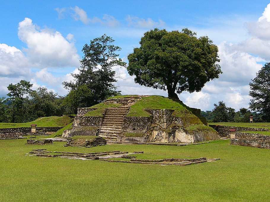
In the morning, you'll take a water taxi across Lake Atitlán, then board a private shuttle for the ride to Iximché. This archeological site in Guatemala's western highlands was once a great capital of the Kaqchikel Maya kingdom back in the 15th century.
On a personal guided tour, you'll visit ancient structures that include plazas, temples, palaces, and two Mesoamerican ballcourts. These ruins were declared a Guatemalan National Monument in the 1960s. After the visit, you'll continue on to Antigua, stopping along the way for lunch.
Day 15: Transfer to Guatemala City & Depart

Enjoy a relaxing breakfast in Antigua as your reward for all the physical exertions over the previous two weeks. At the appropriate time, your driver will transfer you back to Guatemala City and the airport, where you'll catch your flight home. Adíos!
More Great Guatemala Itineraries
Looking for more inspiration for your trip to Guatemala? Check out these other Guatemala itineraries, explore different ways to spend 15 days in Guatemala, or learn about the best time to visit Guatemala.
Map
