

Highlights
- Trek to seven volcano summits in the Guatemalan highlands
- Tour Old Town Antigua, a UNESCO World Heritage site
- Camp on the slopes of the Acatenango volcano
- Hike through cloud forests and across lava fields
- Relax on the peaceful shores of Lake Atitlán
Brief Itinerary
| Day | Highlights | Overnight |
|---|---|---|
| Day 1 | Arrive in Antigua, Explore the City | Antigua |
| Day 2 | Summit Pacaya Volcano | Antigua |
| Day 3 | Hike Acatenango Volcano & Camp Overnight | Acatenango Volcano |
| Day 4 | Sunrise Hike on Acatenango, Transfer to Quetzaltenango | Quetzaltenango |
| Day 5 | Trek to Santa Maria Volcano | Quetzaltenango |
| Day 6 | Climb Zunil Volcano, Transfer to Lake Atitlán | Panajachel |
| Day 7 | Hike San Pedro Volcano | San Pedro La Laguna |
| Day 8 | Hiking & Birding at Toliman Volcano | San Pedro La Laguna |
| Day 9 | Climb Paquisis Volcano, Transfer to Antigua | Antigua |
| Day 10 | Transfer to Guatemala City & Depart |
Detailed Itinerary
Day 1: Arrive in Antigua, Explore the City

Welcome to Guatemala! Upon arrival at the Guatemala City International Airport, a driver will transfer you to the colonial city of Antigua. After settling into your hotel, you'll have free time to explore the city at your leisure.
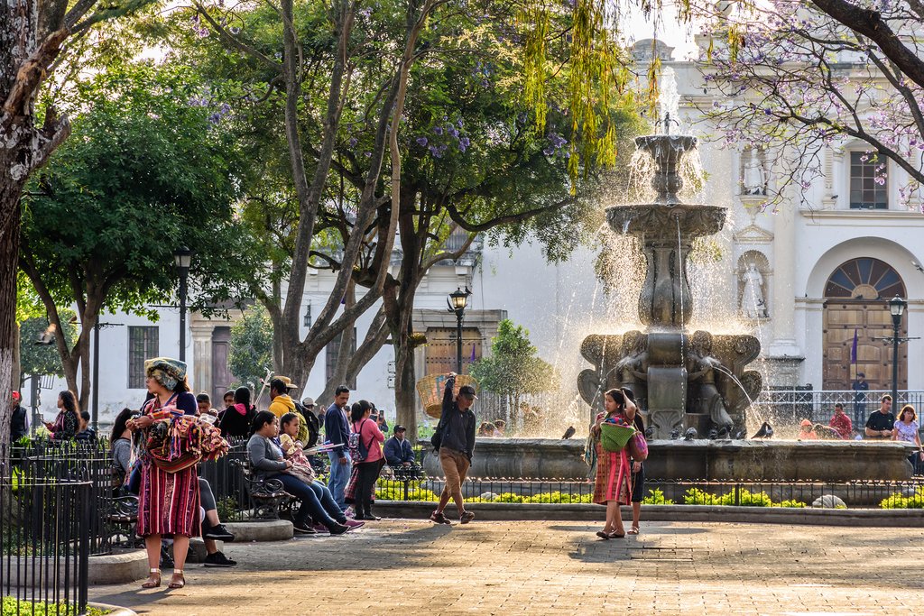
Once the capital of Guatemala, Antigua is surrounded by volcanoes. The contrast between these imposing peaks and the colorful architecture of the city makes it one of the prettiest settlements in the country. Enjoy the rest of your day walking around the cobbled streets, treating yourself to local snacks at cafés and food vendors, and strolling by a few of the main attractions, like the 16th-century Antigua Guatemala Cathedral and the remains of the 18th-century Convento Santa Clara.
Day 2: Summit Pacaya Volcano

One of the hallmarks of Antigua's dramatic skyline is the 8,370-foot (2,552 m) Pacaya volcano. It may not be Guatemala's highest peak, but its slopes are home to some of the most impressive volcanic landscapes in Central America. Set in its own national park, Pacaya is a fascinating active volcano that cuts an imposing figure with its continuous plume of smoke drifting from the summit and the massive dried lava field at the base of its caldera.
You'll embark on a group hike in the morning, and as you move up the mountain trails stunning vistas will appear with every step. Upon reaching the base of the caldera, your guide will lead the group across rugged lava fields that were reformed after an eruption in 2010. Continue traversing these unique volcanic landscapes as you ascend the peak. After conquering the summit, celebrate with a picnic and enjoy panoramic views that include three nearby volcanoes: Agua, Fuego, and Acatenango.
The hike back down takes you across more dried lava fields before descending through Pacaya's tropical forest and farmland. Upon returning to the trailhead, you'll transfer back to Antigua.
- Est. hiking time: 3-4 hours
- Distance: 3.8 miles (6 km)
- Ascent: 1,300 feet (400 m)
- High point: 7,500 feet (2,288 m)
Day 3: Hike Acatenango Volcano & Camp Overnight

This morning, meet your group at the Old Town Outfitters Shop, in Antigua, to prepare your hiking gear and purchase any additional supplies. A one-hour drive then takes you from Antigua to the sleepy mountain village of La Soledad, perched on the Pacific slope of Acatenango. From here, you'll start the two-day/one-night hike up Acatenango to a campsite on the side of this 13,041-foot (3,976 m) mountain.
The trail rises up through four microclimates, each of which will take you about an hour to traverse. You'll begin by walking up a steep path used by villagers to reach their corn, snow pea, and lily crops. The second phase passes through old-growth cloud forests filled with ancient pines. At mid-day, you'll enjoy a picnic lunch complimented by incredible views of the surrounding volcanoes and the Cuchumatanes Mountains.
Temperate coniferous forests and tropical dry forests characterize the third phase of the ascent, which leads to the storm-beaten tree line of the volcano. Your campsite is perched just below it and offers sweeping views of the Antigua Valley and Fuego volcano. After setting up camp, you can relax and enjoy the surroundings while your guide prepares a fresh camp dinner at 12,300 feet (3,750 m). Later, you might get lucky and see a spectacle of light and fire from one of Fuego's eruptions
- Est. hiking time: 5-6 hours
- Distance: 5 miles (8 km)
- Ascent: 3,600 feet (1,100 m)
- High point: 12,300 feet (3,750 m)
Day 4: Sunrise Acatenango Hike, Transfer to Quetzaltenango

Depending on weather conditions, your group will rise early, enjoy the sunrise over volcano peaks, and embark on a 45-minute/one-hour trek up a gravel trail through a pine forest. This is the steepest trail yet, and it leads to the rocky, windy summit of Acatenango's peak.
At the summit, rest and enjoy breathtaking 360-degree views of the Guatemalan highlands stretching all the way to Mexico. After eating breakfast and breaking camp, you'll begin the three-hour descent back to La Soledad. This route follows a different trail, so you can enjoy more beautiful scenery as you descend through different microclimates.
From La Soledad, you'll transfer to the city of Quetzaltenango. Traveling along the Pan-American Highway, you'll pass its highest point, known locally as "Alaska." After lunch at a roadside restaurant, you'll arrive in Quetzaltenango by mid-afternoon. Sitting at an altitude of over 7,500 feet (2,335 m), this is Guatemala's second-largest city and the center of the K'iche' Maya people. Settle into your hotel close to the central Parque Centro América, where you can later enjoy dinner at one of its many fine restaurants.
- Est. hiking time: 2-3 hours
- Distance: 4.5 miles (7 km)
- Ascent: 1,500 feet (475 m)
- High point: 13,000 feet (3,976 m)
Chat with a local specialist who can help organize your trip.
Day 5: Trek to Santa Maria Volcano, Return to Quetzaltenango

Today's trek takes you to the peak of Santa Maria volcano, which soars over 12,360 feet (3,770 m). You'll depart Quetzaltenango early in the morning and drive about 45 minutes over dirt roads to the village of Llanos del Pinal. The trailhead starts here, at 8,200 feet (2,500 m).
The trek begins with a gentle climb through picturesque fields until you reach the base of the volcano's cone. Then it transitions to a steep dirt trail, which is quite muddy, especially after rain. It will take about five hours to reach the summit, at which point you can relax and enjoy spectacular views of the active Santiaguito volcano. Connected to Santa Maria by a saddle, Santiaguito is lower than its sister peak, thus affording a bird's-eye view into its fiery crater. If you're lucky, you might even see an eruption.
After lunch at the summit, you'll head back down the trail and return to Quetzaltenango for the night.
- Est. hiking time: 8-9 hours
- Distance: 6.2 miles (10 km)
- Ascent: 4,100 feet (1,250 m)
- High point: 12,360 feet (3,770 m)
Day 6: Climb Zunil Volcano, Transfer to Lake Atitlán

After breakfast, you'll take a short drive to a new trailhead leading up Zunil volcano. From here, hike about two hours up to an altiplano grassland plateau. While gaining approximately 3,200 feet (1,000 m) in elevation, you'll traverse plains full of sheep, villages, and isolated forests. Eventually, you'll arrive at the Siete Cruces ("Seven Crosses") ridge trail. Here you'll enter a forest of pinabete trees (a rare pine endemic to Guatemala) as you wind along the ridge of Zunil and the neighboring Santo Tomás volcano.
Break for lunch at Pico Zunil, a beautiful campsite at 10,000 feet (3,100 m). Protected from the wind, it offers magnificent views east to the Atitlán and Panchoy Valley volcanoes and west to the peaks of Santa Maria, Santiaguito, and Tajamulco (Guatemala's highest peak at 13,789 ft/4,203 m). After a picnic lunch, you'll return to the vehicle and transfer to Panajachel, the main town on Lake Atitlán, one of the most beautiful lakes in the country.
- Est. hiking time: 5-6 hours
- Distance: 5.5 miles (9 km)
- Ascent: 2,360 feet (720 m)
- High point: 11,620 feet (3,542 m)
Day 7: Hike San Pedro Volcano

Wake up bright and early and eat a hearty breakfast accompanied by strong Guatemalan coffee. Then hop on a private water taxi for the ride to the village of San Pedro, located on the west side of the lake. After transferring to the trailhead, you'll embark on a full-day hike to the peak of San Pedro volcano, which sits at 9,900 feet (3,020 m).
After a 3.5-hour ascent through a dense cloud forest, you'll arrive at the rocky outcropping that forms the summit of the volcano. While snapping photos and relishing the views of the highland scenery (including the neighboring peaks of Toliman and Atitlán across the Bay of Santiago), you'll dine on a picnic lunch with your fellow hikers. The descent back down to the lakeshore will take most of the afternoon, and you'll arrive back at your hotel in San Pedro in the early evening.
- Est. hiking time: 7-8 hours
- Distance: 5.5 miles (9 km)
- Ascent: 4,000 feet (1,200 m)
- High point: 9,900 feet (3,020 m)
Day 8: Hiking & Birding at Toliman Volcano

After breakfast, a private water taxi will take you to the lakeside village of Santiago La Laguna. From the dock, you'll make your way to the main plaza where you'll meet today's local hiking guides.
The route begins with a stroll through Santiago's colorful streets and then along a trail lined with coffee plantations, avocado trees, and cornfields. You'll walk for about two hours on a rocky trail before entering the dense cloud forest. At this point, you might spot native fauna such as deer, the pavo de cacho (a large bird with a distinctive orange feather atop its head), hummingbirds, and perhaps the elusive quetzal. Then continue to the final hiking destination and lunch spot: an incredible cave with scenic views.
After the descent, you'll return to the hotel to relax and savor your final evening on Lake Atitlán.
- Est. hiking time: 8-9 hours
- Distance: 11 miles (17.7 km)
- Ascent: 5,000 feet (1,524 m)
- High point: 10,360 feet (3,158 m)
Day 9: Climb Paquisis Volcano & Transfer to Antigua

Your final trek of the trip is a memorable one. In the morning you'll set out to conquer the mist-shrouded slopes of Paquisis, one of four volcanoes surrounding Lake Atitlán.
Today's trail follows an ancient Maya trading route to the Pacific and passes through lush mountain slopes and cloud forests as you climb to 4,757 feet (1,450 m). While the roughly three-hour ascent can be strenuous, hikers are rewarded with stunning views and some of the best birding in Guatemala—with belted flycatchers, wine-throated hummingbirds, and magnificent horned guans a common sight. In the afternoon, you'll transfer back to Antigua.
- Est. hiking time: 4 hours
- Distance: 4 miles (6.4 km)
- Ascent: 2,500 feet (762 m)
- High point: 9,200 feet (2,800 m)
Day 10: Transfer to Guatemala City & Depart
Your adventure draws to a close today as you enjoy a leisurely breakfast in Antigua before transferring back to Guatemala City for your departing flight home. Adios!
More Great Guatemala Itineraries
Looking for more inspiration for your trip to Guatemala? Check out these other Guatemala itineraries, explore different ways to spend 10 days in Guatemala, or learn about the best time to visit Guatemala.
Map
