
Hiking the Dingle Way
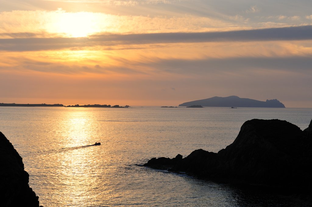
County Kerry's Dingle Peninsula is a less-visited region than the Ring of Kerry to the south—there isn't a continuous road around the peninsula, and there are fewer blockbuster attractions. But therein lies the charm: this is a rare slice of the Ireland where Gaelige (Gaelic) is still spoken, century-old crofts huddle below the mountains, and ancient sites lie scattered across a sparsely populated landscape.
The Dingle Way runs around the best bits of this peninsula, through the spirited traditional towns of Tralee and Dingle, both the peninsula's mountainous areas (Slieve Mish Mountains and Mount Brandon), and one of the most spectacular sections of Ireland's coastline from Dingle to Slea Head.
| Start/End Point | Distance | Highest Elevation | Days Needed | Difficulty | Supply Stops |
| Tralee | 111 miles | 2,165 feet | 6-8 days | Moderate | Tralee, Dingle |
What to Expect

The 111-mile Dingle Way is typically broken down into eight stages, with each stop marked by a village or town with facilities. Facilities can range from basic in the smaller villages to significant in towns like Tralee and Dingle. Each stage is between 10 and 18 miles in length, taking a reasonably fit adult 6.5 to 8.5 hours to walk. Purists should note the Dingle Way does not traverse the entire Dingle Peninsula—the southern section from Castlemaine to Inch Beach isn't covered.
Outside of the main towns of Tralee and Dingle, which both have outdoor supply shops, there are few facilities besides accommodation and places to eat, and even these are sporadic. Weather conditions are frequently wet and windy, so pack the necessary wet/warm weather gear. Camping equipment is not necessary, as there is always accommodation within a two- to three-hour hike at all points of the trail, but note that it's wise to reserve lodging well in advance between March and October.
The hike overall is moderate in terms of difficulty. There are a couple of stretches which are more demanding, with steep climbs, sheer drops and often poor visibility due to clouds, most notably from Feohanagh to Cloghane (Stage 6).
For a detailed Dingle Way itinerary, see our Self-Guided Dingle Peninsula Walk - 6 Days. And much of the Dingle Way is covered by the longer Wild Atlantic Way, which runs the length of Ireland's west coast—you can find more details in this 9-day itinerary.
Chat with a local specialist who can help organize your trip.
Getting There

The Dingle Way begins and ends in Co. Kerry's main town and administrative hub, Tralee. The official trail starts from near the Kerry County Museum in the Ashe Memorial Park, and the route is typically walked clockwise: north from Tralee to Camp, and then southwest towards Annascaul.
Tralee is connected by air via Kerry Airport, 12 miles outside town, which services Dublin, London-Luton, London-Stanstead, and Frankfurt-Hahn. By train, Tralee is connected via central Tralee Casement Station to Mallow, where you can change for services to Cork and Dublin: services run every two hours Monday-Saturday with reduced Sunday services. Regular direct buses also connect Tralee with Cork, and (with a change at Limerick) Galway and Dublin.
The town has spent significant sums of money in recent years making itself an attractive destination to linger in, should time permit—although if you're pressed for time, it's better to spend extra time in Dingle (Stage 3).
Trail Overview

Stage 1: Tralee to Camp (11 miles)
The path follows an old canal towpath to the pretty suburb of Blennerville, where there is accommodation. Blennerville also claims to be home to Ireland's largest working windmill. The trail rises into the Slieve Mish Mountains during this section and passes Tonavene and the archaeological site of Killeton Oratory before reaching Camp.
Stage 2: Camp to Annascaul (10.5 miles)
This stretch passes the only significant forest on the whole route, through a saddle between the Knockbrack and Corrin mountains, eventually descending to the beach at Inch made famous by the WWI movie Ryan's Daughter. The route then veers inland, mostly along small lanes, to reach Annascaul. Would-be explorers take note: the refreshments on offer in Annascaul are in the pub run by Antarctic explorer Tom Crean, the South Pole Inn, decorated with memorabilia from Crean's travels.

Stage 3: Annascaul to Dingle (13.5 miles)
Today's path runs past the ruined Minard Castle, with brilliant beach views across to the Ring of Kerry, then passes Lispole and through Conor's Pass before descending to Dingle town—see the end of this article for tips on where to stay, eat, and recreate in Dingle.
Stage 4: Dingle to Dunquin (12.5 miles)
This part of the walk has some of the most beautiful coastal scenery anywhere in Ireland, passing Ventry Harbor and the dramatic Slea Head headland. Here you can deviate from the trail to walk to Dunmore Head, the westernmost point of Ireland. There are great views out to the most westerly land in all of Europe, the Blasket Islands—you can visit them yourself via ferry from Dunquin, your ending point for the day.

Stage 5: Dunquin to Feohanagh (13.5 miles)
The trail mainly hugs the coastline today and passes Murreagh, where there is a worthwhile side path to the enigmatic archaeological site of Gallarus Oratory. You'll continue through Ballydavid to Feohanagh—if Feohanagh accommodation is booked up, you can stay the night in Ballydavid.
Stage 6: Feohanagh to Cloghane (13 miles)
This is the most difficult section of the trail, with a climb up the slopes of Brandon Mountain via Masatiompan. The trail then loops around idyllic Brandon village, where you can find lodging if needed, and continues skirting the lower slopes of Mount Brandon to Cloghane.

Stage 7: Cloghane to Castlegregory (18 miles)
Stage seven is the longest of the hike—luckily, it's mostly flat. The path runs along the longest stretch of beach in Ireland, Fermoyle Strand (with several accommodations set just back from the shoreline) to the top of a hammerhead-shaped peninsula with great views to the Magharee Islands. The route then heads south down the eastern side of the peninsula to Castlegregory.
Stage 8: Castlegregory to Tralee (16.5 miles)
After a flat coastal section, the trail reaches Camp and rejoins the outward route back to Tralee.
Where to Stay, Eat, and Play in Dingle
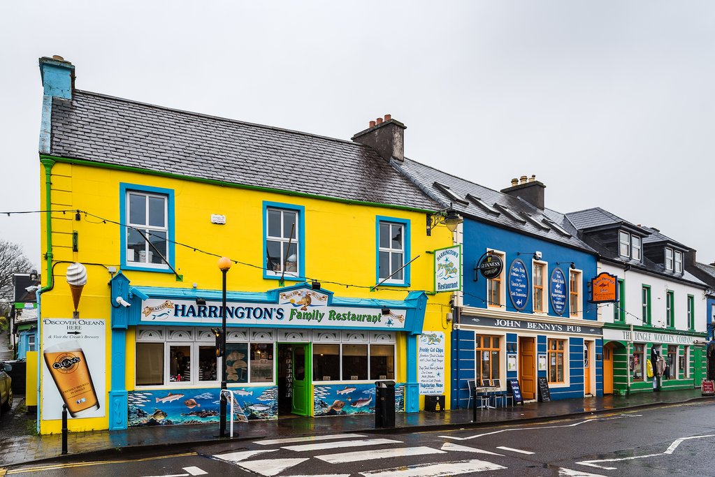
Dingle is a lively town at the end of Stage 3—and of all the towns on the trail, this is the best place to hang up your hiking boots for a day or two.
Things to Do
Dingle's (and indeed, Ireland's) most famous creature is Fungie the dolphin, who frequents the waters around Dingle. Fungie is a relatively rare example of a dolphin who seems to actively seek out human company, and there a number of boat trips out to see Fungie cavorting around the bay. There's also an aquarium—Dingle Oceanworld is home to Ireland's largest collection of sharks. End your day with a drink: the local Dingle Distillery produces whiskey, gin, and vodka, and offers daily tours and tastings.
Where to Stay
You'll have plenty of lodging options in Dingle, and this is one of the few chances to stay in a hotel on your route. Pubs, guesthouses, and bed-and-breakfasts are also available. The stand-out guesthouse is architect-designed Greenmount House with an enviable location just above town center with wonderful views of the bay. Or try the 19th-century stone-built Quayside B&B, another characterful lodging option in the very center of town.
Where to Eat (and Drink)
A Dingle institution, Foxy John's (corner of Main St with Green St) has to be the pick of the pubs: a traditional watering hole which is half-bar, half-jumbled hardware store. The Boat Yard Restaurant & Bar has great harbor views and daily local seafood. And McCarthy's Bar (Goat St.) is one of several venues with regular live music.
For more on walking in Ireland, check out our Ultimate Guide to Multi-Day Walks.
Map
