Glymur Falls Overview

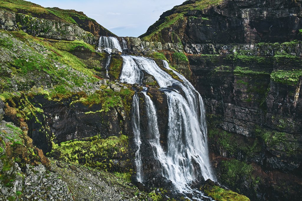
Tucked away into the lush Botnsdalur Valley in one of Iceland’s most beautiful fjords, Hvalfjörður, Glymur is a magnificent 650 foot (198 m) high waterfall that, up until 2007 was considered the highest in the country. It was dethroned by Morsárfoss waterfall in the otherworldly Highlands, which scientists discovered after Morsárjökull - an outlet glacier of Vatnajökull glacier - started melting and revealed the hidden cascades.
Located about 40 miles west of Reykjavik, Glymur is still a hidden gem of the region since it’s not visible from the main road. It will take you about three hours of walking, climbing, crossing rivers and passing caves to reach the top of this truly breathtaking natural wonder. This could be a wonderful day hike just off the popular Golden Circle area, that will take you away from the crowds, and reward you with beautiful views and a solid dose of adrenaline.
Getting There

It will take you about an hour of driving to get from downtown Reykjavik to the parking lot of Glymur, where your hike will begin. Drive northwest on Route 1 from the capital and turn right on Road #47, just before you reach Hvalfjordur tunnel. You will be driving along the fjord’s coast for about 4 miles (6.5 km) before you see a “Glymur” sign - turn here and follow the dirt road until you reach the parking lot.
There are no bathroom facilities, but the parking area does have a detailed map with route options to the top of the waterfall, along with some helpful safety tips.
Chat with a local specialist who can help organize your trip.
The Hike

The entire loop is about 4.6 miles (7.5 km) and depending on your pace could take up to four hours to complete.
The first leg from the hike will take you through the fairly flat terrain of the Botnsdalur valley, which is famous for its lava fields, forests, and overall magnificent vistas. And speaking of lava - the first highlight of this hike is going through the Þvottahellir Lava Cave, or " Wishing Cave." Once you’re on the other side, prepare to test your balance: you will reach a river that can only be crossed by tree log (a rope is hanging above the log that you can use for extra support).
From here on, you have two options for reaching the top: the north route, and the south route. Locals recommend taking the south side on your way up, which offers better views of the waterfall, and the north side on your way down. After the river crossing, the trail gets steeper but there are ropes along the way for you to hold onto. The scene around you also gets more picturesque as you climb higher—you can finally catch a glimpse of the waterfall in all its rugged beauty and the view of the moss-covered canyon underneath it is a sight to behold.
The final leg will take you high above Glymur, and then back down to the top of the falls the where you can take in the breathtaking panorama over the valley. If you're craving more adventure, wade in the calm (albeit cold) river above the falls, or continue the hike up to the Botnsa River and Hvalfell Mountain.
Start your descent along the northern path. This is a much easier route that also offers wonderful views of the waterfall. It re-joins the main trail at the first river crossing and follows it all the way to the parking lot.
When to Go

While the hike is technically accessible year-round, the perfect time to complete it is in the summer. Locals do not recommend trying to climb all the way to the top in the fall or winter - especially if you’re not an experienced hiker - because of the steep slopes that become slippery and icy after snowfall or rain. If the weather isn’t cooperating, guides recommend taking the north route for an easier time.
Another important thing to keep in mind is that the log at the first river is removed in the winter. While that doesn’t necessarily make crossing the river impossible for experienced guides and hikers, if you are a beginner and unfamiliar with the trail, it's better to go back.
Helpful Tips
Since Glymur falls are a short detour away from the Hvalfjordur tunnel which leads to Snaefellsnes Peninsula and the Westfjords, you could easily complete the hike on your way from Reykjavik to West Iceland. As we mentioned it will add about a day to your overall itinerary.
If it’s your first time in Iceland and you are eager to explore the country’s most popular sights, you can simply add Glymur as a stop on your Golden Circle itinerary since the waterfall is about an hour west of Thingvellir National Park.
Should you decide to stay overnight in the area, consider Glymur Hotel and Villas, located 11 miles (18 km) further west from the waterfall along Route 47. The luxurious villas accommodate up to six people and overlook the beautiful Hvalfjordur.
Aside from waterproof clothing, a good, sturdy pair of hiking shoes is essential to complete this hike. Those of you planning to wade the river at the top of the waterfall should also bring a pair of water shoes.