Brief Itinerary
| Day | Highlights | Overnight |
|---|---|---|
| Day 1 | Arrival and Downtown Reykjavik | Reykjavik |
| Day 2 | North to Glymur Falls and Snaefellsnes Peninsula | Snæfellsnes Peninsula |
| Day 3 | Scenic Drive from the Snæfellsnes Peninsula to Akureyri | Akureyri |
| Day 4 | The North: Godafoss, Whale Watching, and Big Waterfalls | Lake Myvatn |
| Day 5 | Scenic Eastern Fjords | Seydisfjordur |
| Day 6 | Jokulsarlon Glacier Lagoon, Diamond Beach, Skaftafell | Kirkjubæjarklaustur |
| Day 7 | Exploring the South Coast | Selfoss |
| Day 8 | Back from South Coast, Reykjanes Peninsula, Departure |
Below are the sights and activities at the top of the bucket list for anyone looking to tackle the famous Route 1. If you have more time, slow down and spend some time in the Westfjords with our 2-week guide to Iceland’s Ring Road.
Detailed Itinerary
Day 1: Glymur Falls and Borgarnes
Drive north from Reykjavik (1-hour drive) and hike to Glymur Falls, Iceland's tallest waterfall (~2 hours out and back). You’ll hike beside a narrow canyon which makes for some great photographs. While you’re in the west, stop by Hraunfossar (“Lava Falls”) and Barnafoss (Children's waterfall), regarded as some of the most unique and spectacular waterfalls in Iceland, where clear subterranean water seeps through the lava fields, pouring out of the rocks, creating Hraunfossar.
Visit some quaint historical towns like Reykholt and Hvanneyri before finishing your day at Borgarnes on the water. If you like, learn more about the Settlement age of Iceland at the Settlement Center, or walk along the shore path near the water.

Day 2: Snæfellsnes Peninsula
The Snaefellsnes Peninsula is sometimes referred to as “little Iceland”, because here you can find a little bit of everything that Iceland has to offer: amazing Basalt columns, tiny fishing villages, coastal cliff walks past arches and other rock formations, lava fields, volcanic craters, black sand beaches, waterfalls, lava caves, and more.
Walk along the Gerðuberg Basalt Cliffs, through the Budhahraun lava fields on the coast (you can continue further to hike to a volcanic crater if you like). Take a cliff-side walk between the tiny fishing villages of Arnarstapi to Hellnar, where you will see really cool cliffs, lava formations and arches in the rocks.
Stop by the huge Londrangar lava formations, and the Djúpalónssandur black sand beach with debris from a shipwreck (cool to photograph the rusted mangled metal pieces on the black sand). Climb up the side of Saxholl Crater (15-20 min stop). Continue your drive around the other side of the peninsula and end your day with a visit to Kirkjufellsfoss waterfall with Kirkjufell mountain in the background (one of Iceland's most photographed) and the Berserkjahraun lava field.
Optional Activity: Vatnshellir Lava Cave Tour

Day 3: Snaefellsnes Peninsula to Akureyri
Spend the morning seeing any sights left to see in the Snaefellsnes Peninsula (Berserkjahraun Lava Fields, Bjarnarhöfn Shark Museum) before you re-join the Ring Road heading clockwise towards Akureyri.
The drive from the eastern side of the Snaefellsnes Peninsula is around 4-4.5 hours to Akureyri. The North of Iceland may be the country’s best-kept secret. While crowds of tourists populate the South and Golden Circle, visitors to Akureyri and Lake Myvatn can enjoy the beautiful landscapes and wonderful volcanic areas all to themselves.
If you have some more time before you arrive at Akureyri, consider a stop at the Grettislaug hot spring (40 minutes off the Ring Road). The spring fits around 15-20 people.
Akureyri
Iceland’s second largest city (18,000 people) sits on Iceland’s longest fjord and makes a great base for exploring the north. While here, be sure to check out the thriving restaurant, cafe, and bar scene and visit the Akureyrarkirkja church on the hill. With more time, follow the path along the calm old harbor and water to see more of the picturesque fjord.

Day 4: Godafoss, Husavik, Asbyrgi, Dettifoss
Spend your morning exploring the rest of Akureyri’s downtown area before you get on the road (Route 1) towards Husavik and Lake Myvatn. Be sure to take a look back towards Akureyri from the other side of the fjord; you can see the mountains behind the town and it makes for a great photograph. Take the scenic route past Husavik, Asbyrgi Canyon, and the waterfalls Dettifoss and Selloss.
After about 35-40 minutes you will see a Route 85 to the left for Husavik. Stay on Route 1 another couple of minutes to reach Godafoss (you will head to Husavik after this detour).

Godafoss Waterfall, the “waterfall of the Gods”
It’s impossible to miss Godafoss, the “waterfall of the Gods”, just off route 1. Hike a couple minutes to see the waterfall up close, or take a longer walk around to see if from multiple perspectives. The waterfall was named when Iceland converted to Christianity in 1000. The legend says that when Þorgeir Þorkelsson, local chieftain and law speaker, made the tough decision to convert the country from the old nordic gods to Christianity (in order to prevent war) he threw the old gods into the falls to symbolize the change to the new era.
Continue back to the Route 1/85 split and drive another 35 minutes to Husavik, the whale watching capital of Iceland.
Husavik: Iceland’s Whale-watching capital
Iceland’s whale watching capital is just over an hour’s drive from Akureyri, making it a good day trip option or a stopover on a loop to Godafoss, Asbyrgi, Dettifoss, and Lake Myvatn.
Unlike in other regions where you must sail a while to find whales, Husavik often has whales, porpoises, and seabirds a few minutes from the harbor. Join a tour on some newer, carbon-neutral ships that are quieter (nicer for whales) and don’t pollute the environment (nice for everyone) We recommend North Sailing, right on the harbor (the entire building, restaurant, and cafe was made from recycled wood).
Check out the whale museum and the church by the harbor before further exploring the region.
Continue along the tip of the Peninsula to arrive at…
Asbyrgi Canyon
Just north of Dettifoss towards the coast, this giant horseshoe-shaped canyon is said to be left by Sleipnir, the eight-legged horse of the Norse god Odin. Others believe it was caused by large floods when glaciers burst and melted almost 10,000 years ago. The canyon is 1km / 0.5 mi wide, 3.5km /2mi long, and up to 100m / 300ft high in some places and offers some spectacular views.
Dettifoss, Selfoss, Hafragilsfoss
Chat with a local specialist who can help organize your trip.
A 30-minute drive from Lake Myvatn (or on a loop from Husavik and Asbyrgi) brings you to Dettifoss, Europe’s most powerful waterfall. A brief hike upstream along the basalt cliffs and you will encounter another giant: Selfoss. If you’re looking for a longer hike, consider hiking a 9 km / 5.5 mi trail to Hafragilsfoss.

Finally, drive 30 min south to Lake Myvatn, one of the most magical areas of the North. If you still have time today, consider some of the shorter walks through lava fields or past craters. Or get an early start and see it all tomorrow.
Day 5: Scenic Eastern Fjords
Note: there is quite a bit to do this day. Get an early start, and maybe skip Hengifoss and Litlanesfoss and Breiðdalsvík. Or, you can hike around Skaftafell on your way before continuing along the South Coast.
Hengifoss and Litlanesfoss
Take a 20-minute detour (40 min there and back) and hike 2.5km / 1.5 mi and you will arrive at Hengifoss waterfall, passing Litlanesfoss on the way. These spectacular waterfalls are framed by huge basalt columns and make for a great activity away from the larger crowds in the south.
Scenic Fjord Route 92
As you drive south from Egilsstaðir, you have the option to take Route 1 to Breiðdalsvík or 92 to 96. While route 1 is about 40 minutes shorter, we recommend the scenic route along several picturesque fjords.
Breiðdalsvík
Take a short break to stretch the legs at this harbor town, just 1 minute off the ring road. While you’re here, stop at Kaupfjelagið where you will find all sorts of small knick knacks and treats: fresh bread, local salted fish, wool clothing, mittens, and hats, or you can pick up a quick meal during your drive.
Djúpivogur
This small town sitting along the fjord makes for a great overnight. Take a short walk (less than 1 mile out and back) along the shore to the lighthouse on the rocks, where you will also have great views of the entire fjords. For coffee or a snack, you may want to try homemade cakes from Langabúð. For lunch or dinner, Hótel Framtíð has great fish dishes.

Höfn
In Höfn, the Pakkus restaurant opens at noon and is well-known for its langoustines and lobster. While here, stop by the visitor center for Vatnajokull National Park where you can learn more about the national park, the town’s history, and watch a couple short films. On the southern side of town, you will find a hill that offers fantastic views of the Vatnajokull Glacier in the distance across the water. This glacier is Iceland’s largest, covering 14% of the country.
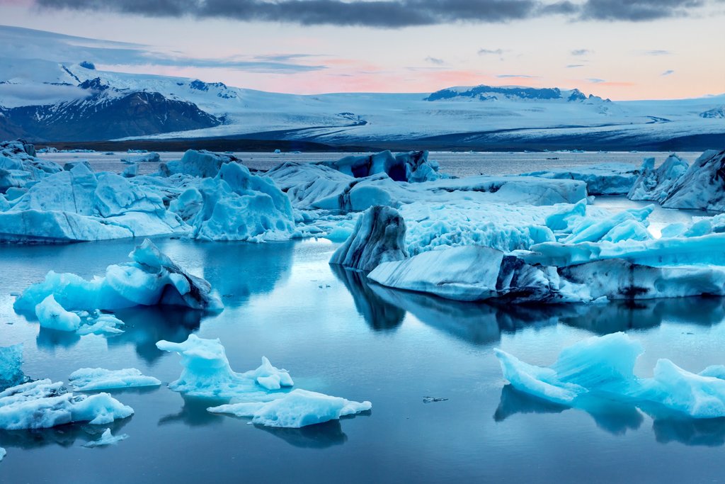
Day 6: Glacier Lagoon and Diamond Beach
From Höfn it's another hour to Jökulsárlón Glacier Lagoon, the highlight of this day. At the Jokulsarlon Glacier Lagoon, you’ll get the chance to see one of the most-unique sights in Iceland: icebergs floating out to sea and beached on the black sand. Climb the hill for a better view of the entire area, or take a 30-minute boat tour into the Lagoon to see the larger icebergs up close. If you like, you can also join a glacier walking tour here.
Follow the river under the bridge to the ocean and you will find many smaller icebergs along the black sandy shores of "diamond beach" where waves crash against them. It’s quite the sight! You may be fortunate to see seals, porpoises, or small whales that sometimes hang out in the lagoon or near the shore.
Fjallsárlón Glacier Lagoon
A few minutes farther south from Jokulsarlon, you will find another Glacier Lagoon about 10 minutes from the parking lot. Here you are much closer to the glacier than at Jokulsarlon, and you’ll have better views of all the cracks and crevices.
Hof
A quick trip off the main road will bring you into Hof where you can check out the Hof Turf church. The practice of covering the roof with turf dates back to Medieval times throughout Europe to protect from the harsh weather.
Day 7: South Coast
Skaftafell and Svartifoss
You could spend many days hiking all the trails around Skaftafell. If you’re short on time, the most popular hike leads to Svartifoss, a thin waterfall surrounded by columns of basalt. The hike is around 3 miles long and offers great views alongside the river and towards the ocean in the distance. If you like, you can join a glacier walking or climbing tour based here.
Fjadrargljufur Canyon
The rock formations in Fjadrargljufur Canyon look like they’re from another world. Hike less than a mile from the parking lot along the ridge of the canyon where you will find some amazing viewpoints where the river curves around this strange rock cliffs.

Fortune Stones at Laufskálavarða Lava Ridge
Between Kirkjubæjarklaustur and Vik, you will find the lava ridge Laufskálavarða with hundreds of small piles of rocks. These piles or rocks were intended to bring good luck to travelers crossing the Mýrdalssandur desert. Get out of your car here to walk around and explore the piles before continuing on to Vik.
Vik
While the town itself is fairly small, its proximity to several great sights more than make up for it, allowing you to explore more of the area in the evening when the larger crowds have left or before the crowds arrive the next day.
Towards the water, you will find a black sand beach with high cliffs on the right side, often filled with soaring and nesting birds.
Reynisdrangar Columns at Reynisfjara Beach
Near Vik along Route 1 you will see a turnoff for Reynisfjara Beach, past a pretty church as you drive towards the water. This black rock beach (not as fine grain as the one in Vik) is most famous for the Reynisdrangar Columns, huge basalt hexagonal columns rising up out of the sand. Walk around the cliffs to the left as you face the ocean and you will find a couple of large caves as well.
Dyrholaey Arch and Cliffs
At Dyrholaey there are 2 parking lots from which you can see the famous arch. The one high on the hill has the better view. You can either take the bumpy dirt road to your right as you enter or better yet hike a short trail near the cliff’s edge to the view at the top (15-20 minutes up). From the top, you will also see a lighthouse and great views looking farther west along a black sand beach that reaches as far as you can see.
Crashed DC-3 Plane on Sólheimasandur Beach
If you’re looking for an odd sight along the south coast, look no further. This US Navy airplane, a Douglas Super DC-3 was forced to crash land here on November 24, 1973. Fortunately, all passengers survived, but the wreckage remains to this day. You can no longer drive directly to the site; park off on either side of the road (you will probably see other cars) and walk the 4 km / 2.5 mi path to the water. Close to the water you will see the wreckage of the DC 3 Plane on your left.
While interesting (and great for photographs), it takes about 2 hours to hike out there and back, so if you’re already planning to see a lot, plan accordingly.

Skogafoss Waterfall
Next, along Route 1 you will find the powerful Skogafoss Waterfall. Skogafoss Waterfall marks the beginning of the 26 km / 16 mi Fimmvörðuháls Trail which ends in Thórsmörk. You can admire the waterfall from the bottom, but you should find the stairs to the right and climb up for a different perspective. Better yet, continue along the Fimmvörðuháls Trail a ways further along the river to “Waterfalls way” where you can see more waterfalls along the canyon and leave the crowds behind).
Practical Info: You will also find a WC at the parking lot, a couple restaurants, and wifi.
Your next stop is Seljalandsfoss waterfall, which you can walk behind. Standing in a cave under the cliff you will see the water come roaring town 20-30 feet in front of you. Pay attention to the direction of the wind, or wear a rain jacket (or both!). You will find 2 smaller waterfalls to the right (if you are looking from behind the waterfall).
Day 8: Golden Circle, Reykjavik

As you leave the South Coast and head towards the Golden Circle Route, consider an evening stop at the Secret Lagoon (Gamla Laugi) in Flúðir, where warm geothermal water flows from the rocks. It’s a great place to end a long day exploring the southern coast.
Here are a few other potential stops along the drive if you still have the time. You can also see Kerid Crater as you complete the Golden Circle.
Seljavallalaug Pool: A short distance after Skogafoss you can make a detour to Seljavallalaug, one of the oldest swimming pools in the country, built in 1923 (look for the small sign to Seljavellir). A short hike past some very cool scenery will take you to the relaxing pool.
Urridafoss: As you reach the end of the south coast drive consider one last waterfall: Urridafoss. While this waterfall may not be as pretty as Skogafoss or Seljalandsfoss, it makes up for it in other ways. Urridafoss is the largest volume waterfall in Iceland, and very wide (and loud). It’s only a short trip from the ring road, and a good finale to the south.
Kerid Crater: Only a short detour from Route 1 on your way back to Reykjavik. Hike around the top of Kerid Crater with its blue lake at the bottom.
Reykjavik
Walk through Reykjavik’s compact downtown area, and along the water past the Sun Voyager Sculpture and to the Harpa Cultural Center with its cool glass architecture. Visit Hallgrimskirkja church on the hill and take the elevator to the tower at for a great overview of the city below and panoramic views of the area. Walk around the harbor or join a whale watching tour. Spend some time learning about Iceland’s history at the Settlement Exhibition or the National Museum of Iceland. Snack on a world famous hot dog at Bæjarins Beztu Pylsur or hop between cafes. In the evenings enjoy a variety of top-tier fish restaurants and Reykjavik’s nightlife.

Map