
Highlights
- Discover impressive waterfalls, including Seljalandsfoss, Dettifoss, and Goðafoss
- Tour geothermal pools, lava fields, volcanoes, and formations around Lake Mývatn
- Board an oak boat for an adventure in the whale-watching capital of Husavik
- Visit fishing villages, waterfalls, and lava fields along the Snaefellsnes Peninsula
Brief Itinerary
| Day | Highlights | Overnight |
|---|---|---|
| Day 1 | Arrival & Drive the South Coast to Vík | Vik |
| Day 2 | South East Glaciers: Skaftafell & Jökulsárlón | Hofn |
| Day 3 | Scenic Eastern Fjords: Hofn to Seyðisfjörður | Seydisfjordur |
| Day 4 | Dettifoss, Krafla, & Geothermal Sights to Lake Mývatn | Lake Myvatn |
| Day 5 | The North: From Mývatn to Laugarbakki | Laugarbakki |
| Day 6 | Laugarbakki to the Volcanic Snaefellsnes Peninsula | Snæfellsnes Peninsula |
| Day 7 | South to Reykjavík: Snaefellsnes Peninsula & West Highlights | Reykjavik |
| Day 8 | Morning in Reykjavík & Departure |
Detailed Itinerary
Day 1: Arrival and drive the South Coast to Vík

Land at Keflavík International Airport (KEF) in the morning, and pick up your rental car. Today is designated for exploration of the South Coast highlights. If you’d like, have breakfast and coffee at KEF. If you prefer to dine in Reykjavík, you can do so as well, but you'll likely need to skip the first stop on your route to the South Coast.
If you bypass breakfast, an optional stop is to head straight to the Reykjanes Peninsula to get the adventure underway. If you plan to drive northwest from KEF, consider the below order, which is listed counter-clockwise:
- Garður Lighthouse: About 15 minutes north of KEF, you will arrive at two lighthouses—one on the coast (older and not as stable), and a second a bit further inland. This scenic area can be a nice area to walk around and stretch your legs after the long flight in today.
- Bridge Between Continents (Europe Miðlína): This area is a great symbol of Icelandic geology. The Reykjanes Peninsula is on the Mid-Atlantic Ridge, which pulls apart a few centimeters every year. You can cross the bridge between the continental plates while you’re here, and look down at the gap below.
- Gunnuhver hot springs and geothermal area: Here, find a couple of bubbling and steaming mud pools. Gunnuhver is named after a female ghost who was said to be trapped in the hot springs more than 400 years ago. Temperatures are extremely hot, so stick to the walkways and viewing areas. While here, continue about 5 minutes to the cliffs to stop at Reykjanesviti lighthouse with beautiful views of Iceland from atop a hill.
- Krýsuvík geothermal area: While you can walk around the area near the parking lot in as little as 5 minutes, take your time to see the steam vents and hot pools up close. Look up at the multicolored hills surrounding the area.
Once you’ve experienced the peninsula, drive toward the South Coast. Note that the sites listed below are located beyond your hotel for tonight, but you can get a jumpstart on the touring today, which will provide a bit more flexibility tomorrow.
The South Shore—between Vík and Selfoss—is full of many popular sights and destinations, and is quickly becoming one of the most popular areas of Iceland. Your first stop is Seljalandsfoss waterfall, with access from behind just a few minutes from the parking lot. Note that the ground is uneven in a few places, and there are stairs on one side. Standing in a cave under the cliff, witness the water come roaring down 20-30 feet in front of you. Pay attention to the direction of the wind or wear a rain jacket (or both). When viewed from behind, spot two, smaller waterfalls to the right, as well.
Next, along Route 1, locate the powerful Skógafoss Waterfall. Skógafoss marks the beginning of the 16-mile Fimmvörðuháls Trail, which ends in Thórsmörk. Admire the waterfall from the bottom, just a 2-minute walk from the parking lot, or if you are up for it, find the stairs to the right and climb up for a different perspective. At the top, walk along the canyon for a bit to see more waterfalls along “Waterfall Way” before turning around.
Note: Depending on snow conditions, this may not be possible.
Then, make your way to the Dyrhólaey arch and cliffs. At Dyrhólaey, there are two parking lots where you can see the famous arch. (The one high on the hill offers the better view.) Take the bumpy, dirt road to your right as you enter. From the top, spot a lighthouse and great views looking further west, along a black-sand beach that reaches as far as you can see. Look for birds flying around; they nest along the cliffside.
As you near Vík, along Route 1, look for the turnoff to Reynisfjara Beach, past a pretty church, as you drive toward the water. This black-rock beach (not as fine-grain as the one in Vík) is most famous for the Reynisdrangar Columns—huge, hexagonal basalt columns rising up out of the sand. Walk 1-2 minutes around the cliffs to the left, as you face the ocean, to find a couple of large caves, as well.
Next, reach Vík. While the town itself is fairly small, its proximity to several great sights more than makes up for it. You can even explore the area in the evening, after the large crowds dissipate, or before the crowds arrive the next day. Toward the water, look for a black-sand beach with high cliffs on the right side, often filled with soaring and nesting birds.
Day 2: South East Glaciers: Skaftafell and Jökulsárlón

Leave Vík in the morning, continuing east along the Ring Road (Route 1, the only major road in this area). Today, take the drive to Jökulsárlón Glacier Lagoon, which is about 2-2.5 hours, total. If you want, you can continue to Hofn, where there is a great visitor center on the glacier and nearby area, and several restaurants serving very fresh seafood (langoustine and lobster are the specialties).
There are many highlights you will pass along the way. You can stop now, or on your drive back later in the day or tomorrow, depending on where you stay this evening.
Fjaðrárgljúfur Canyon is where the rock formations look like they’re from another world. There is a trail less than 1 mile from the parking lot, along the ridge of the canyon, that is home to some amazing viewpoints—where the river curves around these strange rock cliffs. Admire the views along the way, and venture as far as you like.
Visit Skaftafell next, where you could spend many days hiking the trails all around. If short on time, the most popular hike leads to Svartifoss, a thin waterfall surrounded by columns of basalt. The 3-mile hike offers great views alongside the river and toward the ocean in the distance. For further exploration, feel free to join an ice cave tour, a glacier walk, or embark on an ice climbing excursion.
Next, a quick trip off the main road will bring you into Hof, where you can check out Hofskirkja, the turf church. The act of covering the roof with turf dates back to medieval times and was practiced throughout Europe to offer protection from harsh weather.
Just a few minutes before Jökulsárlón Glacier, you will find another glacier lagoon about 10 minutes from the parking lot—Fjallsárlón Glacier Lagoon. Here, you are much closer to the glacier than at Jökulsárlón, with access to better views of all the cracks and crevices.
Next, visit Jökulsárlón Glacier Lagoon, with the chance to witness one of the most unique sights in Iceland: icebergs floating out to sea, and beached on the black sand. Climb the hill for a better view of the entire area.
Follow the river under the bridge to the ocean, and find many smaller icebergs along the black, sandy shores of "Diamond Beach," where the waves crash, creating a memorable sight. You may be fortunate to see seals, porpoises, or small whales that sometimes hang out in the lagoon or near the shore.
Continue 1 hour to Hofn to spend the night.
Day 3: Scenic Eastern Fjords: Hofn to Seyðisfjörður

Today, the road from Hofn continues for another 1.5 hours into the East Fjords, winding along the coastline, to Djúpivogur. On the way, you can stretch your legs and take a short walk along the black-rock beach at the Hvalnes Nature Reserve, where you can see an abundance of birdlife. Look out for hundreds of swans in the calm waters below the jagged cliffs.
This small town of Djúpivogur sitting along the fjord makes for a great overnight. Take a short walk (less than 1 mile out and back) along the shore to the lighthouse on the rocks, where you will also have great views of the entire fjords. For coffee or a snack, try homemade cakes from Langabúð. For lunch or dinner, Hótel Framtíð has great fish dishes.
Then, take a short break to stretch the legs at the harbor town of Breiðdalsvík, just 1 minute off Ring Road. While you’re here, stop at Kaupfjelagið, where you will find all sorts of small knickknacks and treats, including fresh bread, local, salted fish, wool clothing, mittens, and hats, or you can pick up a quick meal during your drive.
As you drive north to Egilsstaðir, you have the option to take Route 1 or Route 96 to Route 92. While Route 1 is about 40 minutes shorter, consider taking the scenic route along several picturesque fjords. After a 30-minute drive over the mountain pass, you will be welcomed with amazing views of the fjord below. Once in Seyðisfjörður, you can hike several trails to waterfalls—two are fairly steep, but only take 5-10 minutes, each. Walk inside cool sound sculptures, visit a troll church, and explore the artwork and sculptures around the city.
If you're looking for a longer hike, head to the northern side of the fjord, and find the parking lot just before Langahlid Seydisfirdi accommodation. Park the car, then start hiking along the trail (which starts as a very rough dirt road). After 10-15 minutes you will arrive at the first waterfall, with several more every 10-15 minutes after that. Hike for as long as you like, and the view back down toward the fjord will keep getting better. If you continue for a full 3 hours or so, you will arrive at a lake at the top—called Vestdalsvatn.
Chat with a local specialist who can help organize your trip.
Day 4: Dettifoss, Krafla, and geothermal sights to Lake Mývatn

The area surrounding Lake Mývatn has the highest concentration of volcanic and geothermal sights in Iceland. In one day, you can explore pseudocraters, rock formations, lava fields, hike up and around a volcanic crater, dip in a thermal pool in a cave, see mud pools and steam vents, see a lake in a volcano, hike a lava area from another world, and finish the day relaxing at the Jarðböðin Nature Baths with a view over all you just accomplished.
First, however, make the drive from Seyðisfjörður, which is about 2 hours total. En route, about 30 minutes from Lake Mývatn (or on a loop from Husavik and Asbyrgi), stop at Dettifoss, Europe’s most powerful waterfall. A 15-minute hike upstream along the basalt cliffs presents another giant: Selfoss.
Next, drive past the Krafla Power Station (also worth a stop) and you will find the Viti Crater, part of the Krafla volcanic system. This crater is filled with a bright-blue lake.
Then, take a walk around the Leirhnjúkur geothermal area, which is otherworldly. After a 10-minute walk, you will arrive at some steam vents. Follow the path through lava fields—where you can see where lava oozed over until it cooled. Make sure you stay on the trail, as there are steam vents all around, and the ground can be very hot in other places. You can hike a big loop in around 1 hour to see all the highlights, or stick to the first sights along the wooden path.
At Hverarond, you can walk around various bubbling mud pits and steam vents, admiring the interesting red and orange colors. Exploring the entire area takes 30 minutes to 1 hour.
Relax in the Mývatn Nature Baths, the North’s equivalent of the Blue Lagoon, but with fewer people, a lower cost, and better views. You won’t find all the spa extras that you do at the Blue Lagoon, but you will find a couple of large geothermal pools, a sauna, and a steam room. You can enjoy views down over the lava fields and the craters around Lake Mývatn as you sit in the mineral water.
Day 5: The North: From Mývatn to Laugarbakki

Today, continue discovering the beautiful sights around Lake Mývatn. The below are listed roughly in order as you would approach from the western side of the lake, driving clockwise around the lake.
The Hverfjall cinder cone is hard to miss from anywhere around Lake Mývatn. Climb up the side for a great view of the surrounding area, where you can see the Skútustaðir Pseudocraters and steam from the Mývatn Nature Baths and Hverarönd geothermal area.
Next, take a 1-hour walk beneath large, strange, contorted Dimmuborgir lava formations, caused when the post-eruption lava flows cooled. You can see the start of the formations with only a 5-minute walk, or hike the small loop in 15 minutes. If you have longer to devote, take your time and walk the bigger loop (2 miles) to see Kirkja (“The Church”), a natural lava formation that resembles a vaulted church arch, and explore a nearby cave a bit further.
Then, visit the Skútustaðir Pseudocraters, which were formed when hot lava flowed over the wet marsh area causing steam explosions. Take an easy, 1-hour walk among many pseudocraters on the shores of Lake Mývatn, and loop around the smaller lake, Stakhólstjörn. Hike up to a few of them, or just walk around the collection. Enjoy the nice views across the lake, where you will see steam rising from the geothermal areas and other volcanic craters in the distance.
After your in-depth exploration of Lake Mývatn, continue west, and you will soon reach the magnificent Goðafoss Waterfall, “Waterfall of the Gods,” which is impossible to miss. Hike a few minutes to see the waterfall up close, or take a longer walk around for views from different perspectives. The waterfall was named when Iceland converted to Christianity in 1000 CE. The legend says that when Þorgeir Þorkelsson, local chieftain and law speaker, made the tough decision to convert the country from the old Nordic gods to Christianity (in order to prevent war), he threw the old gods into the falls to symbolize the transition into the new era.
If you’d like to add an optional whale-watching tour into the day’s mix, head to Husavik. Unlike in other regions, where you must sail a while to find whales, Husavik often has whales, porpoises, and seabirds swimming just a few minutes from the harbor. Join a tour on some newer, carbon-neutral ships that are quieter (nicer for whales) and don’t pollute the environment (nice for everyone). Consider an excursion with North Sailing, which is right on the harbor (the entire building, restaurant, and café is made from recycled wood).
Iceland’s second-largest city (18,000 people), Akureyri sits on Iceland’s longest fjord and makes a great base for exploring the north. While here, walk around the compact downtown area, visit the Akureyrarkirkja church on the hill, or follow the path along the calm, old harbor and water to see more of the picturesque fjord. This is a good lunch spot before continuing further for the rest of the drive.
Just off Route 1 sits Víðimýrarkirkja Turf Church. Built in 1834, it is one of the only remaining preserved turf churches in Iceland. There has been a church in this area since the year 1000.
Just a 5-10-minute drive off Route 1, along Route 75, a visit to the Glaumbær Farm is a great way to experience the turf houses and to see how Icelanders used to live. The turf helped to insulate the houses during the harsh winters and strong winds. The last person lived in this house until 1947, but the oldest farm in the area dates back to around 874 (during the early Settlement Period).
A short distance from the shore along the Vatnsnes peninsula in Northwest Iceland, you will find the black-and-white rock formation known as Hvítserkur (“White Shirt"), a basalt troll, who, according to the legend, was caught in the sun and turned into stone. While it's a nice sight from above, there’s also a trail leading down from the parking lot. This area is also home to one of the largest seal colonies in Iceland—you can learn more at the Icelandic Seal Center in nearby Hvammstangi.
Day 6: Laugarbakki to the volcanic Snaefellsnes Peninsula

Leave the Ring Road behind today, and head out to the Snaefellsnes Peninsula, which is sometimes referred to as “Little Iceland,” because you can find a little bit of everything that Iceland has to offer here: amazing basalt columns, tiny fishing villages, coastal cliff walks past arches and other rock formations, lava fields and caves, volcanic craters, black-sand beaches, waterfalls, and more.
First, pass by the town of Stykkishólmur, which has several worthwhile restaurants, including Sjávarpakkhúsið and Narfeyrarstofa. Then, pass the Berserkjahraun lava fields and head toward Grundarfjörður.
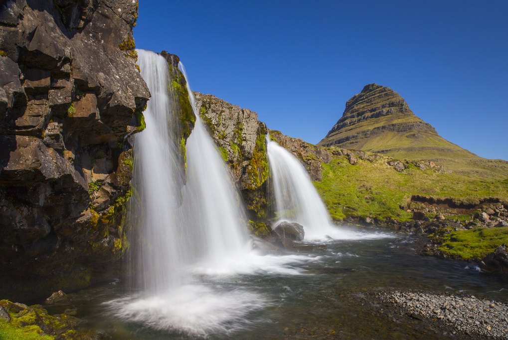
Your first major destination of the day is Kirkjufellsfoss waterfall, with Kirkjufell mountain in the background—one of Iceland's most photographed peaks.
Continue driving around the top of the peninsula until you reach Saxholl Crater, which pops up just along the road and only takes 1 minute to drive to from the main road. Once parked, climb the curved staircase to the top of the crater for a great vantage point of the surrounding area. The climb only takes 10 minutes or so.
Then, take a stroll along Djúpalónssandur, a black-sand beach with debris from a shipwreck—the rusted remains along the black sand make for a beautiful photo opportunity. Here, find four stones of different sizes, which were once used by sea captains to test the strength of sailors interested in joining their crews.
A little further along the road is the peninsula’s Visitor Center, where you can learn more about the volcanic system and the area.
Next, visit the large Lóndrangar lava formations, which you can view from afar, or walk 15 minutes to see up-close.
The twin fishing towns of Arnarstapi and Hellnar are connected by a very pretty cliffside walk past interesting rock formations, and through a small lava field (a 3-mile walk, roundtrip). Take a 2-hour break from the drive to walk along the cliffs with views of the arches below, and stop for a fish soup lunch at Fjöruhúsið in Hellnar before heading back along the trail. (If you’re in between meals, they also offer homemade cakes, bread, coffee, and waffles.)
In Arnarstapi, start at the harbor and continue along the marked trail, with several short turnoffs for better views of the cliffs below. Keep an eye out for Gatklettur, a rocky arch, or the Bárðar Saga Snæfellsáss statue, which is constructed of many piled stones. For the second half of the stroll, walk through a lava field, this time without as much grass, so that you can really see the unique lava formations up close.
Day 7: South to Reykjavík: Snaefellsnes Peninsula and West highlights

Drive south to Reykjavík today. On the way, stop and hike to Glymur Falls, which offers great photographs. With extra time, make a stop by Hraunfossar (“Lava Falls”) and Barnafoss (“Children's Waterfall”), both known for hosting some of the most unique and spectacular waterfalls in Iceland. Clear, subterranean water seeps through the lava fields, pouring out of the rocks and creating Hraunfossar.
Visit some quaint historical towns, like Reykholt and Hvanneyri, before finishing your day at Borgarnes on the water. If you’d like, learn more about the Settlement Age of Iceland at the Settlement Center, or walk along the shore path near the water.
When you're done with the day’s discoveries, continue to Reykjavík to spend your final evening.
Day 8: Morning in Reykjavík and departure

Wake up and enjoy a nice breakfast on your last day in Iceland. Restaurant recommendations in Reykjavík include the below:
- Bergsson Mathús (opens at 7 am)
- Sandholt (also opens at 7 am)
- Reykjavík Roasters (for great coffee)
- Brauð & Co. (if you like bread and pastries)
Walk through compact downtown to check out the unique street art scene. Head to the water for the Sun Voyager Sculpture and the Harpa Concert Hall, with its unique, glass architecture. Visit Hallgrímskirkja, a church on the hill, and take the elevator to the top of the tower for a great view of the city below and panoramic views of the area.
Stroll around Reykjavík Harbour or join a whale-watching tour. Spend some time learning about Iceland’s history at the Settlement Exhibition or the National Museum of Iceland. Snack on a world-famous hot dog at Bæjarins Beztu Pylsur, or hop between cafés.
Then, make the 40-minute drive to KEF to catch your flight home. Arriving 2-2.5 hours before your flight is recommended. Safe Travels!
Map


