
Highlights
- Spend two nights in Reykjavik for dining and cultural sights
- Visit the quiet Snæfellsnes Peninsula on the west coast
- Hike around Lake Myvatn on Iceland's sunnier, drier north coast
- Get to the clifftop above Dyrhólaey Beach for views of the famous arch
- Enter the cave behind the roaring Seljalandsfoss waterfall for photos
Brief Itinerary
| Day | Highlights | Overnight |
|---|---|---|
| Day 1 | Arrive in Reykjavik, Explore Downtown | Reykjavik |
| Day 2 | Glymur Falls, Borgarnes & Snæfellsnes Peninsula | Snæfellsnes Peninsula |
| Day 3 | Explore Snaefellsnes Peninsula | Snæfellsnes Peninsula |
| Day 4 | Snaefellsnes Peninsula to Akureyri | Akureyri |
| Day 5 | Godafoss, Whale Watching & Big Waterfalls | Lake Myvatn |
| Day 6 | Geological Wonders of Lake Myvatn | Lake Myvatn |
| Day 7 | Scenic Eastern Fjords | Seydisfjordur |
| Day 8 | Jokulsarlon Glacier Lagoon, Diamond Beach & Skaftafell | Kirkjubæjarklaustur |
| Day 9 | Waterfalls, Black Sand Beaches & Golden Circle | Golden Circle |
| Day 10 | Golden Circle to Reykjavik | Reykjavik |
| Day 11 | Reykjanes Peninsula, Blue Lagoon, Departure |
Detailed Itinerary
Day 1: Arrive in Reykjavik, Explore Downtown

Welcome to Iceland! Upon arrival at Keflavík International Airport, you'll pick up your rental car and drive 30 minutes into Reykjavik. Since many international flights land in the early morning hours, you'll likely want to start your adventure with a hearty breakfast. There are café and restaurant options in the city center that open early.
From here, you'll have the rest of the day to explore the world’s most northerly capital city.
Things to do in Reykjavik:
- Walk through Reykjavik’s compact downtown area and check out the unique street art scene.
- Head to the waterfront to see the Sun Voyager Sculpture and Harpa Concert Hall with its cool glass architecture.
- Visit Hallgrimskirkja church on the hill and take the elevator to the tower for panoramic views of the area.
- To escape inclement weather, consider visiting a few museums such as the Northern Lights Center, the Saga Museum, the Marine Museum, or the Whales of Iceland Exhibition. You can also join a whale watching tour from the Reykjavik harbor, and snack on a world-famous hot dog at Bæjarins Beztu Pylsur.
In the evening, enjoy a variety of top-tier fish restaurants, as well as Reykjavik’s lively nightlife (especially on weekends).
Day 2: Glymur Falls, Borgarnes & Snæfellsnes Peninsula

After breakfast in Reykjavik, you'll pack up the rental car and head north to experience Iceland's west coast and the Snaefellsnes Peninsula. Both of these areas see fewer visitors compared to the Golden Circle and south coast and will provide you with a bit more time to take in the sites at your own pace.
First, stop for a hike at Glymur Falls, Iceland's tallest waterfall (2 hours out and back). You’ll hike beside a narrow canyon which makes for some great photographs.
Continue on your drive towards the peninsula and stop in Borgarnes where you can learn about the Settlement age of Iceland at the Settlement Center, or simply walk along the shore path near the water. If you have extra time, make some stops at the other quaint historical towns like Reykholtand Hvanneyri.
Once you get to the peninsula, head for the Gerðuberg Basalt Cliffs, where unusual basalt columns rise up out of the earth. You can park the car and walk around exploring the area while getting a closer look. Next, walk through the start of the Budhahraun lava fields on the coast, covered in moss or snow depending on the season.
Keep driving until you get to the village of Hellnar where you can stop for dinner at the small café near the water to taste their delicious fish soup and enjoy the setting.
Day 3: Explore the Snaefellsnes Peninsula

Today, you'll continue your peninsula explorations starting with the cliff-side trails at Arnarstapi where you can get up close to some great views, lava formations, and arches in the rocks. In fact, you can walk the trail all the way to Arnarstapi from Hellnar, starting from either direction.
Then, head for the Londrangar lava formations, which you can view from afar or up close (about 15 minutes by foot). A little further along the road is the Visitor Center for the peninsula where you can learn more about the volcanic system and the area.
If the weather is dry, take a stroll along Djúpalónssandur black sand beach with debris from a shipwreck (tip: photograph the rusted mangled metal pieces on the black sand). Here you will find four stones of different sizes, which were used by sea captains to test the strength of people wanting to join their crew. While facing the water, look for a small trail on the right-side cliffs that leads to the site of a major fishing operation.
As you near the westernmost point of the peninsula, look for signs for Saxholl crater. If you have time, it's worth the stop to walk up the stairs that take you to the top with nice views of the surrounding area.
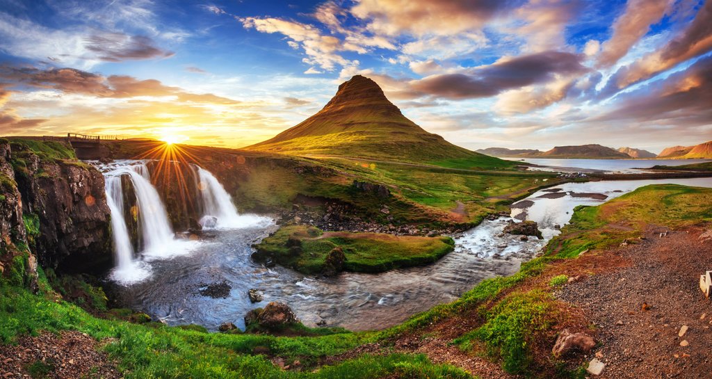
Continue your drive around the other side of the peninsula and end your day with a visit to Kirkjufellsfoss waterfall with Kirkjufell mountain in the background (one of Iceland's most photographed).
You can either spend the night in Grundarfjordur near the mountain and waterfall or continue to the larger town of Stykkishólmur. On the way (and if you're brave enough), you can stop at the Bjarnarhöfn Shark Museum and taste some Hakarl, or fermented shark.
Day 3: Snaefellsnes Peninsula to Akureyri

Chat with a local specialist who can help organize your trip.
Spend the morning seeing any sights that you may have missed in the Snaefellsnes Peninsula (Berserkjahraun Lava Fields, Bjarnarhöfn Shark Museum) before you re-join the Ring Road heading clockwise towards Akureyri.
The scenic drive from the eastern side of the Snaefellsnes Peninsula to Akureyri is around 4-4.5 hours and you'll want to keep your camera close. The north coast of Iceland may be the country’s best-kept secret. While crowds of tourists populate the south coast and Golden Circle, visitors to Akureyri and Lake Myvatn can enjoy the beautiful landscapes and wonderful volcanic areas all to themselves. A few stops to keep in mind on your drive:
-
Icelandic Seal Center in Hvammstangi (10 minutes off the Ring Road): This area is also home to one of the largest seal colonies in Iceland. Look for several sea watching spots along the coast a bit north of here.
-
Hvítserkur, “white shirt” basalt troll (add an hour to your drive): Close to the shore along the Vatnsnes peninsula is the black and white rock formation known as Hvítserkur—a troll who, according to the legend, was caught in the sun and turned into stone. While it's a nice sight from above, you'll also find a trail leading down from the parking lot.
- Varmahlíð: Stop in this small town, where Route 1 and Route 75 intersect (an hour before Akureyri). Here you can visit the Glaumbær Farm and the Víðimýrarkirkja Turf Church. This is a great way to experience the turf houses and to see how Icelanders used to life. The turf church, built in 1834, is one of the only remaining preserved turf churches in Iceland.
When you arrive in Akureyri, Iceland’s second largest city of 18,000 people, get out and walk around town. Be sure to check out the thriving restaurant, cafe, and bar scene, and visit the Akureyrarkirkja church on the hill. With more time, follow the footpath along the calm old harbor to see more of the picturesque fjord.
Day 4: Godafoss, Whale Watching & Big Waterfalls

Spend your morning with breakfast in Akureyri before you get on the road (Route 1) towards Husavik and Lake Myvatn. Be sure to take a look back towards Akureyri from the other side of the fjord; you can see the mountains behind the town and it makes for a great photograph.
After about 35-40 minutes on the road, you will see Route 85 to the left for Husavik. Despite this sign, stay on Route 1 for another couple of minutes to reach Godafoss (you will head to Husavik after this detour).
When you arrive at the “Waterfall of the Gods”, hike a couple minutes to see Godafoss up close, or take a longer walk around to see it from multiple perspectives. The waterfall was named when Iceland converted to Christianity in 1000. Legend says that when Þorgeir Þorkelsson (local chieftain and law speaker) made the tough decision to convert the country from the old Nordic gods to Christianity (in order to prevent war), he threw the old gods into the falls to symbolize the change to the new era.
From here, you'll continue back to the Route 1/Route 85 split and drive another 35 minutes to Husavik, the whale watching capital of Iceland. Unlike in other regions where you must set sail to find whales, Husavik often has whales, porpoises, and seabirds close to the harbor. You can join a tour on newer, carbon-neutral ships that are quieter (nicer for whales) and don’t pollute the environment (nice for everyone). We recommend North Sailing, right on the harbor, and the entire building, restaurant, and café was made from recycled wood). Also, check out the whale museum and the church by the harbor.
From here, head to Dettifoss, Europe’s most powerful waterfall. Take a 15-minute hike upstream along the basalt cliffs and you will encounter another giant: Selfoss. You can approach from either the east or west side of the river (there are two roads): The road on the west is paved, while the one on the east is gravel. Both sides offer nice views of the waterfalls, but you have a nicer view of the full canyon from the east.
Continue driving to Lake Myvatn and spend your evening relaxing in the Myvatn Nature Baths—the North's equivalent of the Blue Lagoon, but with fewer people, cheaper prices, and better views. You won’t find all the spa extras that you do at the Blue Lagoon, but you will find a couple of large geothermal pools, a sauna, and a steam room. You can enjoy views down over the lava fields and the craters around Lake Myvatn as you sit in the mineral water.
Day 5: Geological Wonders of Lake Myvatn

The area surrounding Lake Myvatn has the highest concentration of volcanic and geothermal sights in Iceland. In one day you can explore a plethora of pseudocraters, rock formations, lava fields, and volcanic craters
The following sights are listed roughly in order as you would approach from the western side of the lake driving counterclockwise.
-
Skutustadir pseudocraters: These pseudocraters were formed by when hot lava flowed over the wet marsh area causing steam explosions. Take an easy walk among many pseudocraters on the shores of Lake Myvatn and loop around the smaller lake Stakhólstjörn. You can hike up to a few of them or just walk around them all. Enjoy nice views across the lake where you will see steam rising from the geothermal areas and other volcanic craters in the distance.
-
Dimmuborgir lava formations and “the Church”: Take a walk beneath large, strange, contorted lava formations caused when lava flows cooled. You can see the start of the formations here or hike the small loop in 15 minutes. Or, walk the bigger loop (2 miles) where you will see Kirkja (“The Church”), a natural lava formation that resembles a vaulted church arch, and a nearby cave a bit further.
-
Hofdi rock formations: A little past Dimmuborgir you will see a small turnout for Hofdi. You could spend anywhere from 15 minutes to over an hour here walking the wooded trails that take you to some very unique rock formations in the lake.
-
Hverfjall cinder cone & crater walk: The volcano known as Cinder Cone is hard to miss from anywhere around Lake Myvatn. Climb up the side for a great view of the surrounding area where you can see the Skutustadir Pseudocraters and steam from the Myvatn Nature Baths and Hverarond Geothermal area.
- Hverarond mud pits & steam vents: As you leave Lake Myvatn heading east, your first detour is the Hverarond geothermal area. Here you can walk around various bubbling mud pits and steam vents, admiring the interesting red and orange colors. Exploring the entire area takes from 30 minutes to an hour.
Just after Hverarönd, you will see a turnoff for Krafla/Viti. Take the road and drive 10 minutes for these attractions:
-
Krafla/Viti crater: Drive past the Krafla power station (also worth a stop) and you will find the Viti crater, part of the Krafla volcanic system. This crater is filled with a bright blue lake.
- Leirhnjúkur lava fields & geothermal area: Explore the Leirhnjúkur area and you will think you were on another planet. After a 10-minute walk, you will arrive at some steam vents. You can hike a big loop in an hour to see all the highlights, or stick to the first sights along the wooden path
Day 6: Myvatn to the Eastern Fjords

Many people tend to skip right past Iceland's East Fjords, making a beeline from Myvatn to the south coast. With the extra time, though, as this trip allows, you can treat yourself to some of the most scenic and remote coastlines in Iceland with a night in the picture-perfect Scandinavian town of Seydisfjordur.
In this region, you will find lots of beautiful calm fjords, outdoor activities, and small towns at the bases of large mountains. You can even kayak through the fjords, or (for a longer trip) take a ferry to either the Faroe Islands or Denmark.
Here are ideas for scenic day hikes:
-
Hengifoss & Litlanesfoss: Take a 20-minute detour (40 minutes there and back) and hike until you arrive at Hengifoss waterfall, passing Litlanesfoss on the way. These spectacular waterfalls are framed by huge basalt columns and make a great activity for those who prefer to escape the larger crowds in the south. During early summer, you may also spot some puffins in the area.
- Seydisfjordur: After a 30-minute drive over the mountain pass, you will be welcomed with amazing views of the fjord, below. Once in Seydisfjordur, you can hike several trails to waterfalls (two are fairly steep but they only take 5-10 minutes each), walk inside cool sound sculptures, visit a troll church, and explore the artwork and sculptures around the city. If you're looking for a longer hike, head to the northern side of the fjord and hike past several waterfalls continuing all the way to the top (Vestdalsvatn).
Day 7: Jokulsarlon Glacier Lagoon, Diamond Beach & Skaftafell

Today, you'll depart Seydisfjordur in the morning and continue southwest along the Ring Road (Route 1, the only major road in this area) to Jokulsarlon Glacier Lagoon, about 4-4.5 hours away. Here are some attractions in the area:
-
Diamond Beach: At the Jokulsarlon Glacier Lagoon, you’ll get the chance to see one of the most unique sights in Iceland: icebergs floating out to sea and beached on the black sand. Climb the hill for a better view of the entire area or follow the river under the bridge to the ocean for smaller icebergs along the black sandy shores of "diamond beach" where waves crash against them. It’s quite the sight! You may be fortunate to see seals, porpoises, or small whales that sometimes hang out in the lagoon or near the shore.
-
Fjaðrárgljúfur Canyon: The rock formations in Fjadrargljufur Canyon look like they’re from another world. There is a trail less than a mile from the parking lot along the ridge of the canyon where you will find some amazing viewpoints where the river curves around this strange rock cliffs. You can admire the views the entire time and go as far as you like.
-
Skaftafell & Svartifoss (optional ice-caving & glacier walks): You could spend several days hiking all the trails around Skaftafell. If you’re short on time, the most popular hike leads to Svartifoss, a thin waterfall surrounded by columns of basalt. The hike is around three miles long (weather dependent) and offers great views alongside the river and towards the ocean in the distance. If you like, you can join an ice cave/climbing tour or glacier walking tour based here.
-
Fjallsárlón Glacier Lagoon: A few minutes before Jokulsarlon, you will find another Glacier Lagoon about 10 minutes from the parking lot. Here you are much closer to the glacier than at Jokulsarlon, and you’ll have better views of all the cracks and crevices.
- Hof: A quick trip off the main road will bring you to Hof's turf church. The practice of covering the roof with turf dates back to medieval times throughout Europe to protect from the harsh weather.
When your adventures are complete, drive to the town of Vik for the night.
Day 8: Waterfalls, Black Sand Beaches & the Golden Circle

After breakfast at your hotel, you can re-connect to the Ring Road heading west and spend the day enjoying popular highlights along Iceland's south coast. The section between Vik and Selfoss is full of cool sites and destinations and is quickly becoming one of the most beloved areas of Iceland. Leave the crowds behind by hiking further on the trails away from the parking lots. There is a lot to see.
Near Vik, along Route 1, you will see a turnoff for Reynisfjara Beach, past the town's iconic red church as you drive towards the water. This black rock beach (not as fine grain as the one in Vik) is most famous for the Reynisdrangar Columns, huge basalt hexagonal columns rising up out of the sand. Walk around the cliffs to the left as you face the ocean and you will find a couple of large caves as well.
Further on the route is Dyrholaey, and there are two parking lots from which you can see the famous arch. The one high on the hill has the better view. Take the bumpy dirt road to your right as you enter. From the top, you will also see a lighthouse and great views looking farther west along a black sand beach that reaches as far as you can see. Look for rare birds (and perhaps even puffins) flying around—they nest along the cliffside.
Also along Route 1, you will find the powerful Skogafoss Waterfall. This marks the beginning of the 16 miles (26 km) Fimmvörðuháls Trail, which ends in Thórsmörk. You can admire the waterfall from the bottom (a short walk from the parking lot), or if you are up for it, find the stairs to the right and climb up for a different perspective. At the top, walk along the canyon to see some more waterfalls along “waterfalls way” before turning around (note: depending on snow conditions this may not be possible).
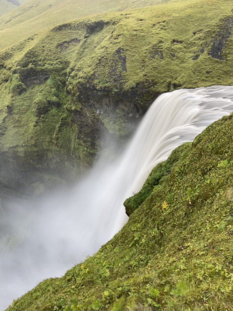
Continue driving west to Seljalandsfoss waterfall, which you can walk behind (the ground is uneven in a few places but there are stairs on one side). Standing in a cave under the cliff you will see the water come roaring down in front of you. Pay attention to the direction of the wind, or wear a rain jacket (or both!) You will find two smaller waterfalls to the right if you are looking from behind the waterfall.
As you leave the South Coast and head towards the Golden Circle Route, consider an evening stop at the Secret Lagoon (Gamla Laugi) in Flúðir, where warm geothermal water flows from the rocks. It’s a great place to end a long day exploring the southern coast.
Day 9: Golden Circle to Reykjavik

Today is a good day to head out early and visit Gullfoss and Geysir before the crowds and buses arrive when you’ll have these magnificent places all to yourself.
At Gullfoss (“Golden Falls”) you can walk along a few different paths to see the tremendous falls from different angles and perspectives. You’ll want to spend some time here admiring the incredible amount of water that flows over the edge every second.
Next, keep driving to the Geysir geothermal area where the Strokkur geyser shoots into the sky like clockwork every 5-10 minutes. In between eruptions walk around the hot pools, steam vents, or climb the small hill above it all for a great view.
End your tour of the Golden Circle Route at Thingvellir National Park and learn about the traditions of the old Icelandic Parliament that met each summer at Law Rock. Walk between the giant rock fissure where the tectonic plates meet. In the visitor center, you can learn more about the history and geology of the area.
Another option for those brave enough to get in the water is to join one of the snorkel and scuba dive tours near here, where you can swim between the North American and Eurasian tectonic plates.
Consider a short detour Kerid Crater where you can walk around the rim of the volcano or down to the bottom to see the blue lake below.
In the afternoon, you'll head back to Reykjavik where you'll have another night in the city to take advantage of anything you may have missed at the beginning of the trip.
Day 11: Reykjanes Peninsula, Blue Lagoon, Depart Iceland

It's time to say farewell to Iceland! Depending on your departure flight, you can spend your last day exploring more of Reykjavik or check out some highlights around the Reykjanes Peninsula. Here are a few ideas to consider:
-
Reykjanes Peninsula: This peninsula is often missed by travelers quickly heading between Reykjavik and KEF airport. With a bit more time, you can explore lava fields, geothermal areas, and small fishing towns.
-
Blue Lagoon: Enjoy a relaxing soak (and a drink!) in the iconic Blue Lagoon before you fly home (great for all ages).
- Gardur Lighthouse: Two lighthouses are located near the airport: one on the coast (older and not as stable), and a second one a bit further inland. With nice coastal views, these are great opportunities to get out and stretch your legs before your flight.
Map