
Highlights
- Pass through numerous hill and mountain villages that see few trekkers
- Experience the warmth of the local Nepali people
- Spot rare wildlife in the Sagarmatha National Park (Red Pandas & Snow Leopards)
- Follow beautiful rivers and cross high suspension bridges for a great thrill
- Enjoy mountain vistas of some of the highest peaks in the world: Everest, Lhotse, Nuptse
Overview
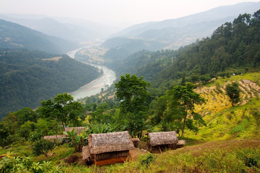
This challenging trek starts with a flight to Tumlingtar (to the east of Everest). The first week is spent trekking through a variety of hill and mountain terrain that sees few visitors, before heading onto the main Everest trail to Kallapattar. Here, there are classic and spectacular close-ups of Everest, Nuptse, and Lhotse.
Culturally, the Arun Trek is very interesting, moving from Sherpa through to Rai villages, then down to Chhetri and Brahmin villages. This trek follows an ancient route that takes you through farming villages, across valleys, through high mountain settlements and past monasteries. The views grow even more spectacular as you venture up the Dudh Kosi River to Namche Bazaar, the gateway to the Khumbu region.
The trail then leads to Pangboche via Khumjung, where you will be rewarded with spectacular views of Ama Dablam, Everest, Lhotse, Thamserku, Kwangde, and Tawache. The route follows the Imja Valley to Dingboche and up to the outstanding viewpoint of Kala Patthar and Everest Base Camp.
The trail then returns to Lukla, via the more frequented Everest Base Camp route. Part of this trek passes through the Sagarmatha National Park, a UNESCO World Heritage site. Himalayan wildlife commonly seen are musk deer, mountain goats, colorful pheasants, rare Red Pandas and even Snow Leopards. Pine, juniper and birch trees are common here, as well as colorful rhododendron flowers in spring.
Brief Itinerary
| Day | Highlights | Overnight |
|---|---|---|
| Day 1 | Welcome to Kathmandu! | Kathmandu |
| Day 2 | Explore Kathmandu | Kathmandu |
| Day 3 | Fly to Tumlingtar; Trek to Kartiki Ghat | Kartiki Ghat |
| Day 4 | Trek to Gothe Bazaar | Gothe Bazaar |
| Day 5 | Trek from Lankuwa and Dhobani to Tala Phedi and Salpa Phedi | Salpa Phedi |
| Day 6 | Trek from Salpa Phedi to Guranse | Guranse |
| Day 7 | Trek through Salpa Bhanjyang to Sanam | Sanam |
| Day 8 | Trek from Sanam to Gudel | Gudel |
| Day 9 | Trek to Kiraunle Gompa | Kiraunle |
| Day 10 | Trek to Najing Dingma, via Surkie Pass | Najing Dingma |
| Day 11 | Trek from Najing Dingma to Pangom | Pangom |
| Day 12 | Trek from Pangom to Puiyan | Puiyan |
| Day 13 | Trek from Puiyan to Phakding | Phakding |
| Day 14 | Trek to Namche Bazaar | Namche |
| Day 15 | Rest day in Namche; Acclimatize | Namche |
| Day 16 | Trek from Namche to Tengboche | Tengboche |
| Day 17 | Trek from Tengboche to Dingboche | Dingboche |
| Day 18 | Rest day in Dingboche; Acclimatize | Dingboche |
| Day 19 | Trek from Dingboche to Lobuche | Lobuche |
| Day 20 | Trek from Lobuche to Gorak Shep | Gorak Shep |
| Day 21 | Trek to Everest Base Camp; Return to either Gorak Shep or Lobuche | Gorak Shep or Lobuche |
| Day 22 | Return to Pangboche; Visit The Himalayan Rescue Association | Pangboche |
| Day 23 | Return to Namche | Namche |
| Day 24 | Trek to Lukla | Lukla |
| Day 25 | Fly to Kathmandu | Kathmandu |
| Day 26 | Depart Kathmandu |
Detailed Itinerary
Day 1: Welcome to Kathmandu!

As you fly into Kathmandu, you'll have beautiful views over the valley, the Himalaya, and of the terraced fields below. After going through customs, a representative will be waiting to guide you through the initial culture shock of Kathmandu’s narrow, winding streets and get you settled into your hotel. Once you've settled in, head out and visit one of Kathmandu's cultural highlights. In the evening, the tourist hub of Thamel is a good place to grab your first meal, with a variety of restaurants to chose from offering both Western and local Nepali dishes.
Day 2: Explore Kathmandu

Kathmandu has a special atmosphere during the early morning hours when the city is slowly coming to life yet not too chaotic. It's a great time to walk and explore the streets or have a chai overlooking one of the local courtyards or durbar squares. There are a number of ways you can spend the day given the many incredible sights around the Kathmandu Valley. Later in the evening, head out for dinner at one of the city's great eateries, or your specialist can arrange a home-cooked dinner with a local family.
Day 3: Fly to Tumlingtar, trek to Kartiki Ghat

Fly from Kathmandu to Tumlingtar early in the morning to start the trek through the Arun Valley. You'll have beautiful views over the city, the Himalaya, and of the terraced fields below.
After arriving in Tumlingtar, begin the trek. The mountains in the distance are Chamalang to the left and Makalu to the far right. Follow the small road through the long village and adjoining series of small, lively villages and colorful tea-houses. Many locals will share the trail, as well as trains of mules carrying cardamom, the biggest cash crop in the region. After an hour, reach a fantastic suspension bridge with side ties, stretching across the wide Arun River. Then, drop down to the sandy riverside, peppered with boulders. Following the river closely, pass terraced rice fields, buffalos, thatched huts and villagers working in the fields.
Have lunch at Chewa Besi, then continue to Kartiki Ghat, a village known for bees and honey. Stay overnight here at a teahouse.
Day 4: Trek to Gothe Bazaar (2,247 feet/ 685 m)

Start the morning with an easy 20-minute walk to the lovely village of Balwa Besi, where you cross a small river. Then, start climbing through a lush, tropical forest of cardamom, banana and papaya trees, and past thatched huts to a chautara (local rest-spot), which is a spectacular viewpoint high above the hazy valley and the Arun River. You then have quite a climb before lunch.
Contouring around hillsides, climb to Marduwa, a small hamlet, passing more terraced fields and clusters of ochre and cream mud-brick houses built in the local style. Stop for lunch near Nepali Danda (also called Charlissay). Reach the intersection of the old trail from Dingla, and after contouring around a hillside, join a larger trail near a cluster of banyan trees. The forest thickens as you ascend and then drop back down to the Irkhuwa River, crossing two bridges and following a riverside trail for another hour or so to Gothe Bazaar. Here, the inhabitants are Gurung and Rai.
Day 5: Trek to Salpa Phedi (4,986 feet/ 1,520 m)
After breakfast, head towards Lankuwa village and then further on to Dhobani, a village of paper-makers. Delicious tangerines are sold along the trail by local villagers, so pick up some for the day. Cross the river on a flexing bamboo bridge and trek through several small picturesque whitewashed villages with thatched roofs. Pass through Lankuwa village and then start the steep, uphill climb to Dhobani. Along the way, keep an eye out for the traditional fishermen with their long bamboo nets. Continue through a thick tropical forest, climb the 'waterfall steps' and eventually reach Tala (Lower) Phedi, where paper is also made.
Stop for lunch before hiking another hour uphill along a lovely trail backed by undulating grasses, rocks, and fruit trees. Reach Salpa Phedi, where you'll stay overnight.
Day 6: Trek to Guranse (Chayaksila) (9,842 feet/ 3000 m)
Start the morning with a steep climb up stone steps through upper Salpa Phedi, then keep climbing, with increasingly amazing views down the valley. It will take you several hours of climbing to reach Jau Bari, a village that grows the best barley in the region. Here, there is a Sherpa monastery just below a lovely Sherpa-run campsite. Stop for a breather here, then continue past terraced fields and through rhododendron forests. Pass the turnoff for Salpa Lake and stop overnight at a local porter stop with several Sherpa houses.
Day 7: Trek to Sanam (9,317 feet/ 2,840 m)

The Salpa Bhanjyang pass (11,023 feet/ 3,360 m) is the border of Solu Khumbu and the Sherpa region. It's a short ascent to get here, just over an hour to the chorten-topped windy pass, where there are wonderful views of snow-capped Karylung Peak. Descend steeply through the forest following a small stream and several mani walls to the Lidung Khola. There, cross to the north bank and continue to a few local teahouses. An hour or so afterward, reach the picturesque Sherpa village of Sanam, a lovely village with traditional Sherpa houses and terraced fields. Stay overnight in a teahouse.
Day 8: Trek to Gudel (6,446 feet/ 1,965 m)
Leaving Sanam, contour along a high trail with broad views, first reaching Duire (Tiu), a group of simple lodges. Soon afterward, arrive at the rustic gompa at Nimtsola. Here, Sherpa influence ends as you enter the land of the Rai. The trail is now larger. Finally, reach the buffalo huts and terraced fields of the large Rai village of Gudel, a bustling and interesting place. The village of Bung and the Naulekh mountains are visible in the distance, as is Mera Peak. Descend steeply on slate steps to a campsite at the back of a local teahouse, your stop for the night.
Day 9: Trek to Kiraunle Gompa (8,333 feet/ 2,540 m)
Today is a long but rewarding day. Begin by steeply descending past rice paddies and cardamom plants to the river far below. Cross a long bridge and begin the equally steep ascent to Bung. Following the stream on a rock trail, ascend a switch-backing trail after crossing the Hungu Khola. Bung means 'beautiful flower' in the Rai language, and is indeed a lovely large village, renowned for its tongba (millet beer).
The entrance to the Makalu Barun National Park is just past the school in the village. Continue to trek with great views and cooler temperatures until reaching a grassy plateau, your lunch stop. After a bit of 'off-trail' climbing, arrive in the recently built Kiraunle-Chambaling Gompa, your stop for the night.
Day 10: Trek to Najing Dingma, via Surkie Pass (10,072 feet/ 3,070 m)
Today there is another pass crossing, which takes two and a half to three hours to reach the crest. Heading straight to the ancient moss-covered chortens and mani walls on the ridge, pass through a rhododendron forest. At the intersection by the teahouses, head up towards the Surkie pass (10,072 feet/ 3,070 m) There are better views at the sightseeing platform just above the narrow pass ridge, from where you'll be able to see Karylung, Khatang, and Numbur mountains.
Afterward, the descent is steep down along a rocky trail and through a bamboo forest, but you'll soon arrive at your overnight destination, Najing Dingma. This tiny hamlet and grazing area has a few small teahouses and shops, set on a flat green section of the hillside.
See 'Variations' section below for alternative routes on days 8, 9, and 10.
Chat with a local specialist who can help organize your trip.
Day 11: Trek to Pangom (9,350 feet/ 2,850 m)

Today is another day of steep climbs and a pass. Descend from Najing Dingma for an hour through leafy woods, to Gai Kharka, another small village of only a few thatched huts. Continue descending steeply to the rickety bridge high above the Inkhu Khola. From here, make the steep ascent up a path, about which the owner of a nearby teahouse said: "It's so steep that even the monkeys fall off!" It takes two to three hours to reach the next village, but as you gain altitude you are also treated to spectacular views of the Inkhu Valley, with Mera Peak looming ahead.
Shubuche (8,727 feet/ 2,660 m) is a large village spread over the hillside, marked by Tibetan prayer flags. From there, it will take another hour of climbing to reach the two small teahouses below the pass, and another hour to reach the Pangum La (or Satu La) pass (10,416 feet/ 3,175 m). From there you'll be able to see the trail from Jiri, the Trakshindo La and the incredibly scenic Sherpa village of Pangum below.
After another half hour's walk, reach your scenic campsite at the back of a friendly Sherpa lodge. Pangom is home to a few nice lodges, the Hillary School, fields marked by wooden fences and a Tibetan Buddhist gompa. Enjoy a fantastic sunset across the wide open valley, with Karylung rising majestically in front across the Dudh Kosi (the 'milk river' that leads to the Khumbu region).
Day 12: Trek to Puiyan (8,956 feet/ 2,730 m)
Heading out of town, past the long rows of old mani walls, you can look out at the hilltop villages of Bupsa and Karikhola in the distance. Instead of walking towards them, veer right on a smaller wooded trail towards the small hamlet of Kharte (2.5 hours away) and then the Khari La (wide pass). It will take a good hour and a half of contouring and climbing to crest the pass (10,088 feet/ 3,075 m), but the views are amazing from the top.
Have your first view of the sacred Sherpa peak, Khumbu Yul Lha (Khumbila), Gyachen Kang and then Kusum Kangaru, just around the corner. It's a quick descent on a rocky trail to the main Jiri trail, and then just another half an hour to the charming village of Puiyan, your stop for the night.
Day 13: Trek to Phakding (8,713 feet/ 2,656 m)
The trail now leaves the tributary valley and heads more directly north towards Chaurikharka (8,900 feet/ 2,713 m). Before ascending, the main trail crosses a spectacular deep gorge with a high waterfall (7,900 feet/ 2,408 m). Chaurikharka, a large scattered village with a monastery and a high school, is the breadbasket of the Khumbu area, as the land is fertile and crops like barley, wheat, and green vegetables are grown. After this village, the trail from Lukla joins that towards Phakding. The path becomes quite busy with trekkers, porters and pack animals. Several hours of walking along a scenic trail bring you to Phakding.
Day 14: Trek to Namche Bazaar (11,318 feet/ 3,450 m)

From Phakding, cross and re-cross the river on high suspension bridges. Beyond Monjo is the entrance to the Sagarmatha National Park, which was established to protect and preserve the fragile mountain environment. From there, take a steep hike to Namche. If the weather is clear, you will get your first glimpse of Everest. Namche is the main trading village in the Khumbu and has a busy Saturday market as well as numerous shops, lodges, and restaurants.
Day 15: Rest day in Namche
Namche is tucked away between two ridges amid the giant peaks of the Khumbu. It is an ideal place to spend a day acclimatizing to the altitude. To help acclimatize, visit Khunde Hospital, established by Sir Edmund Hillary, or take a one hour walk up to the Everest View Hotel above Namche for views of Ama Dablam, Nuptse, Lhotse, and Everest. There are also good views from the National Park Centre and Museum just above the town.
Day 16: Trek to Tengboche (12,687 feet/ 3,867 m)
From Namche, the trail contours along the side of the valley, high above the Dudh Kosi. Get your first really good views of the great peaks of the Khumbu from here, including Everest, Lhotse, Nuptse, and Ama Dablam. Passing several villages and numerous tea shops, descend steeply to a bridge over the river at Phunki Tenga, an ideal stopover for lunch and rest spot before climbing steeply to Tengboche.
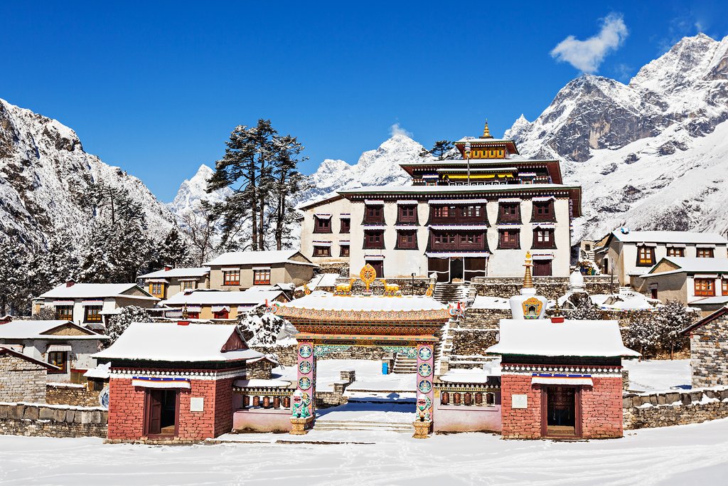
Although the hike up the zigzag path is tiring, it presents many beautiful sights, including rhododendron bushes, beautiful birds, and superb mountain scenery. Tengboche is famous for its legendary monastery, the largest in the Khumbu, and a great spot for taking photographs. A spectacular panorama of Everest, Lhotse, and Ama Dablam can be seen from the campsite.
Day 17: Trek to Dingboche (14,304 feet/ 4,360 m)

On the way to Pangboche village, choose the upper trail for better views. Pass several chortens, mani walls and small villages. The lunch stop not only serves delicious food but also allows a fantastic close-up of Ama Dablam (6,856 m./ 22,493 ft.). In the afternoon, walk north to Pheriche, or take the eastward trail beneath the towering north face of Ama Dablam. From here, the walk is fairly moderate as you enter the Imja Valley.
The valley gradually unfolds as you approach the confluence of the Lobuche River. Descend to the river and begin the last and steepest climb of the day, up to Dingboche. On arrival, notice the beautiful fields enclosed by stone walls, growing barley, buckwheat, and potatoes.
Day 18: Rest day in Dingboche

Spend your second acclimatization day at Dingboche. A breakfast with an Ama Dablam view to the south is memorable. Climb the ridge to the north behind the village for an ideal acclimatizing excursion. From the top, you can see three of the world's six highest peaks—Lhotse, Makalu, and Cho Oyu—as well as Cholatse, Taboche, Lobuche West, and Lobuche East.
Day 19: Trek to Lobuche (16,174 feet/ 4,930 m)
Continue trekking up the wide valley, beneath the impressive peaks of Cholatse and Tawache on the left. Turn right and climb steeply towards the foot of the Khumbu Glacier. The teahouse at Duglha is a good place for lunch. The trail zigzags up through the boulders of the glacier's terminal moraine. At the top of this climb, there are many stone cairns, built as memorials to the Sherpas who have died climbing Mount Everest. The path then climbs gently along the glacier, to eventually reach a cluster of houses at Lobuche.
Day 20: Trek to Gorak Shep (17,007 feet/ 5,184 m)

To reach Kala Pattar, follow the Khumbu Glacier. The trail offers superb views of the surrounding mountains, especially where the path is forced to rise to cross a tributary glacier. Stop for lunch at the overnight camping place, Gorak Shep, and afterward, climb up to one of the finest viewpoints in the Everest region, Kala Pattar (18,221 feet/ 5,554 m). As the light begins to fade, descend gently to the camp at Gorak Shep and have an early night, in preparation for the trek to Everest Base Camp the next day.
Day 21: Trek to Everest Base Camp (17,575 feet/ 5,357 m)

A very early start is required to reach the Everest Base Camp, as it takes several hours to weave through ice pinnacles and past the crevasses of the Khumbu Glacier. On the return, take a higher route for a spectacular view of the Khumbu Icefall and the South Col. Return to either Gorak Shep or Lobuche.
Day 22: Trek to Pangboche (13,074 feet/ 3,985 m)
Today’s trek is mostly downhill, as the faster, downhill journey towards Lukla commences. Retrace your steps to Duglha and descend to Pheriche. Stop in at The Himalayan Rescue Association, a trekker’s aid post, which is an informative place for a visit. After lunch, cross the Khumbu Khola on a wooden suspension bridge and follow the Imja Khola to Pangboche.
Day 23: Trek to Namche

Continue to follow the river and, after crossing it, climb back up through birch and rhododendron forests to Tengboche. Kwangde, Tawache, Everest, Nuptse, Lhotse, Ama Dablam, Kantega, and Thamserku are just a few of the Himalayan giants to be seen. From Tengboche, descend to the bridge over the Dudh Kosi. At Phunki Tenga, see the water driven prayer wheels, before making your way back to Namche.
Day 24: Trek to Lukla (9,186 feet/ 2,800 m)
The final day of trekking follows the Dudh Kosi down to Lukla.
Day 25: Fly to Kathmandu
Pack up early and head for the airstrip to hop a flight back to Kathmandu.
Day 26: Depart Kathmandu

Time to say farewell to Nepal. Enjoy your last moments in Kathmandu with breakfast in a café, a city stroll, and/or souvenir shopping. A representative will meet you at your hotel and drive you to the airport for your return flight home. It's good to be at the airport at least two hours prior to departure.
Variations
Instead of flying back from Lukla, it is possible to walk back to Jiri and take a bus to Kathmandu. This follows the old "pioneers' route", which is the trek that the early Everest area explorers and mountaineers followed before Lukla was connected to Kathmandu by air. This will add about a week onto the trek.
On Day 8, instead of trekking over the pass to Najing Digma, you can head to Mera Peak. Mera Peak is the highest trekking peak in Nepal (6,476 m./21,246 ft.), and an ascent of the mountain is just one of the highlights of this amazing expedition.
On Day 9, instead of trekking to Pangom, you can head towards Phaplu. This small town has an airstrip and is an alternative to Lukla to exit this trek. Reaching Phaplu will take about four days from your turn-off point on the Arun Valley trek. The advantage of this route — aside from cutting the above itinerary shorter if you are pressed for time — is that it gets very few trekkers, so continues the under-explored theme of the Arun Valley trek. A further alternative, if you are even shorter on time, is to fly out from Lukla to Kathmandu without continuing on to Phaplu.
Accommodation
There's a bit of everything on this trek! The Arun Valley trek is still remote, but there are teahouse facilities available for small groups. Impromptu lodgings can also be found in some places, with local villagers. Many people are very generous and hospitable towards travelers. In other places, camping will be necessary. Once the classic Everest Base Camp route has been joined, the quality (and price) of the lodges increases, as this is a popular area. There are even options to stay in quite luxurious accommodation in Namche Bazaar and other places along the EBC route if you would prefer.
Best season
This trek is possible to operate in any season, but the weather and views will be best in spring (March-May) and autumn (September-November). Extra preparation will be needed for winter (December-February) and monsoon (June-August) treks.
Getting there & away
Fly Kathmandu to Tumlingtar to begin this trek. There are two flights per day. On the return trip, fly Lukla to Kathmandu. There are numerous flights per day, but poor weather can often delay departures (sometimes for up to several days), so don't book very tight connections at the end of your trip.
Permits
As part of this trek passes through the Sagarmatha National Park, a permit for here is required ($30 USD). You'll also need a TIMS permit ($10 USD).
Map
