Dolomites High Traverse - 10 Days

Highlights
- Hike between mountain huts high in the beautiful Northern Dolomites
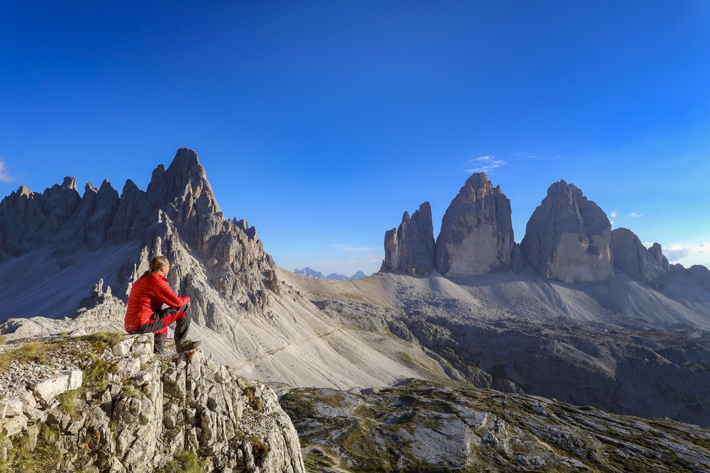
- See the Tre Cime di Lavaredo peaks from the region's famous via ferrati
- Relax and enjoy Italian cuisine in cozy refugi lodges along the way
Brief Itinerary
| Day | Highlights | Overnight |
|---|---|---|
| Day 1 | San Candido - Val Campo di Dentro - Dreischusterhütte | Mountain Hut |
| Day 2 | Dreischusterhütte - Rifugio Locatelli - Tre Cime | Mountain Hut |
| Day 3 | Rifugio Locatelli - Rifugio Pratopiazza | Mountain Hut |
| Day 4 | Rifugio Pratopiazza - Lago di Braies | Braies |
| Day 5 | Lago di Braies - Sora Forno Pass - Rifugio Malga Ra Stua | Mountain Hut |
| Day 6 | Rifugio Malga Ra Stua - Fodara Vedla - Pederu - Fanes | Mountain Hut |
| Day 7 | Fanes - Medesc - Alta Badia - Rifugio Gardenaccia | Mountain Hut |
| Day 8 | Gardenaccia - San Silvestro - Passo Sella - Rifugio Freidich August | Mountain Hut |
| Day 9 | Passo Sella - Friedich August Path - Rifugio Alpe di Tires | Mountain Hut |
| Day 10 | Alpe di Tires - Rosengarten - Nova Levante - Bolzano |
Detailed Itinerary
Day 1: San Candido - Val Campo di Dentro - Dreischusterhütte

Meet your group in San Candido in the early afternoon for a short hike that will give you time to settle in to the Dolomites. This easy, pleasant walk will take you to the Dreischusterhütte, your first Dolomiti rifugio, the cozy lodges that dot the mountain chain.
Hiking time: 30 minutes
Hiking distance: 1 mile (2 km)
Elevation: +361 feet (110 m)
Day 2: Dreischusterhütte - Rifugio Locatelli - Tre Cime

Hike up the upper valley to the Torre di Toblin, the entrance to the world of the three peaks of the Tre Cime mountain group. The area is famous for its rock climbing and via ferrata iron climbing routes that were originally constructed during World War I. You'll make your way to the Locatelli rifugio built in 1883, one of the oldest in the Dolomites. After settling in to your room, you can choose to go for an additional hike at the foot of the area or around the famous Tre Cime or take a guided route around the Paterno or Torre di Toblin via ferrata.
Hiking time: 3 hours
Hiking distance: 4 miles (6 km)
Elevation: +2,789 feet (850 m), -328 feet (100 m)
Day 3: Rifugio Locatelli - Rifugio Pratopiazza

Take in your last views of the north face of Tre Cime as you leave Locatelli and head west. You'll follow an easy trail down the wild Val Ribon. From the bottom of the valley, you'll go up the Strudelkopfsattel Pass under the Monte Specie to discover the pasture of the Pratopiazza.
Hiking time: 6 hours
Hiking distance: 10 miles (16 km)
Elevation: +2,953 feet (900 m), -4,265 feet (1,300 m)
Day 4: Rifugio Pratopiazza - Lago di Braies

Transfer to Ponticello and make your way up an easy path to the Malga Rosalm hut. Follow a traverse along the meadows to the Cavallo Pass, then down to Braies Lake nestled between the mountains.
Hiking time: 5.5 hours
Hiking distance: 7 miles (12 km)
Elevation: +2,953 feet (900 m), -4,429 feet (1,350 m)
Day 5: Lago di Braies - Sora Forno Pass - Rifugio Malga Ra Stua
Chat with a local specialist who can help organize your trip.

Take a brief backtrack down yesterday's trail, then join up with the Alta Via Dolomiti 1 through the Sora Forno Pass and down to the Biella rifugio. Keep descending into the valley past its two scenic lakes and down to the valley floor and the Malga Ra Stua hut.
Hiking time: 5.5 hours
Hiking distance: 8 miles (13 km)
Elevation: +2,953 feet (900 m), -2,461 feet (750 m)
Day 6: Rifugio Malga Ra Stua - Fodara Vedla - Pederu - Fanes

Enjoy some rest on a shorter day as you follow a historical path built by the Austrians during World War I to the rifugio Fodara Vedla. Continue down to Pederu and rejoin Alta Via Dolimiti 1, making a last push up the Fanes Valley to a pristine open pasture.
Hiking time: 4 hours
Hiking distance: 7 miles (11 km)
Elevation: +2,543 feet (775 m), -1,312 feet (400 m)
Day 7: Fanes - Medesc - Alta Badia - Rifugio Gardenaccia

Travel back to a thousand years ago as you hike across the Fanes altiplano (high plain), once an island with a lagoon, keeping your eye out for fossils that would have once been buried on the lakebed. When you reach the Medesc Pass, you'll hike down to La Villa Stern, the hearth of Alta Biada, along a steep path into the woods. Stroll through the village for a rest and shopping time before you climb up to the Gardenaccia rifugioand its view over Marmolada, the highest summit of the Dolomites. If you need some assistance, you can take a lift part of the way.
Hiking time: 7 hours
Hiking distance: 9 miles (15 km)
Elevation: +3,937 feet (1,200 m), -3,937 feet (1,200 m)
Day 8: Gardenaccia - San Silvestro - Passo Sella - Rifugio Freidich August

Take a short hike to the Gardenaccia Pass and then follow a traverse to the Puez rifugio, taking in the views of the Marmolada and neighboring summits. The path goes steeply down to the San Silvestro valley, where you'll cross a pasture to the San Silvestro church and village of Selva-Wolkenstein. From there, hop a bus to the famous Passo Sella and make one more hike along an easy trail to get to your hut for the evening.
Hiking time: 5.5 hours
Hiking distance: 9 miles (15 km)
Elevation: +2,133 feet (650 m), -3,281 feet (1,000 m)
Day 9: Passo Sella - Friedich August Path - Rifugio Alpe di Tires

Follow a long balcony traverse on the Friedrich August path to the Passo di Fassa. Then continue west up to the Val Duron, reaching the Alpe di Tires rifugio at the door of the famous Rosengarten range.
Hiking time: 4 hours
Hiking distance: 7 miles (12 km)
Elevation: +2,297 feet (700 m), -1,640 feet (500 m)
Day 10: Alpe di Tires - Rosengarten - Nova Levante - Bolzano

Your last day takes you across the mineral landscape of the Rosengarten group up to the rifugioPasso Principe stick on the rock. An easy descent takes you down to rifugio Valojet, where you can choose either a shorter challenging hike to the Coronelle Pass and rifugio or a longer, easier route to the rifugio Paolina. Regardless of which route you choose, you'll end with a descent via lift to the Nova Levante valley, where you'll pick up a bus transfer to Bolzano to wrap up your adventure.
Hiking time: 5-6 hours
Hiking distance: 6-8 miles (9-13 km)
Elevation: +1,000 m, -1,100 m
Map
