Highlights
- Explore Þingvellir National Park, and snorkel where the tectonic plates meet
- Check out the incredible South Coast glacial areas of Skaftafell and Jökulsárlón
- Discover the highlights of the Westman Islands and visit a puffin colony
- Embark on several scenic hiking trails in the stunning Thorsmork Valley
Brief Itinerary
| Day | Highlights | Overnight |
|---|---|---|
| Day 1 | Arrival & Golden Circle Highlights | Golden Circle |
| Day 2 | Ferry to Westman Islands | Westman Islands (Vestmannaeyjar) |
| Day 3 | South Coast Waterfalls, Black-Sand Beaches, & Cliffs | Kirkjubæjarklaustur |
| Day 4 | Glaciers at Skaftafell & Jökulsárlón Glacier Lagoon | Kirkjubæjarklaustur |
| Day 5 | Highlands Hiking at Thorsmork | Thorsmork |
| Day 6 | South Coast Back to Reykjavík | Reykjavik |
| Day 7 | Reykjanes Peninsula & Departure |
Detailed Itinerary
Day 1: Arrival and drive to Þingvellir, Geysir, and Gullfoss in the Golden Circle

Welcome to Iceland! Arrive at Keflavík Airport (KEF) in the morning, and pick up your rental car. Stop in Reykjavík for breakfast, or just head straight out to explore the highlights of the Golden Circle, Iceland's most popular area.
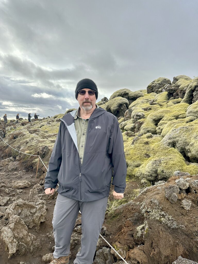
Start with a tour of Þingvellir National Park, where the tectonic plates meet. Visit historical Law Rock, where chieftains from all over the country met once a year to discuss laws and issues, some traveling up to 17 days each way on foot or horseback. Þingvellir is also home to the Silfra Fissure, where you can join a snorkel or scuba tour, and dive between tectonic plates in crystal-clear water.
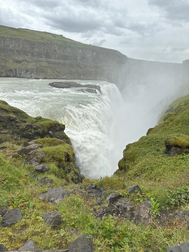
Next, visit the Geysir geothermal area, with bubbling mud pits and steam vents—the Strokkur geyser erupts like clockwork every 10 minutes—followed by a trip to Gullfoss (“Golden Falls”), a massive waterfall that is sure to impress.
Finish your day at Secret Lagoon in Flúðir. Enjoy a relaxing soak in the geothermal waters and a possible glimpse of the Northern Lights (from September-April, depending on the weather).
Day 2: Drive the Golden Circle and take the ferry to the Westman Islands

Today, make your way to the beautiful Westman Islands—typically skipped by busy, roundtrip travelers, but a local favorite of many Icelanders. Leave the Golden Circle area and join the Ring Road heading east toward Seljalandsfoss waterfall, where you will turn off Route 1 toward the Landeyjahöfn Ferry Terminal. (More details on an extended stop at Seljalandsfoss tomorrow, so you can get the most out of your time on the islands today.)
Board a 30-minute ferry ride from Landeyjahöfn Harbor, and take advantage of a free afternoon on the island. The Vestmannaeyjar (another name for Westman Island) range in age from 50-40,000 years old. There are several ways to spend the afternoon.
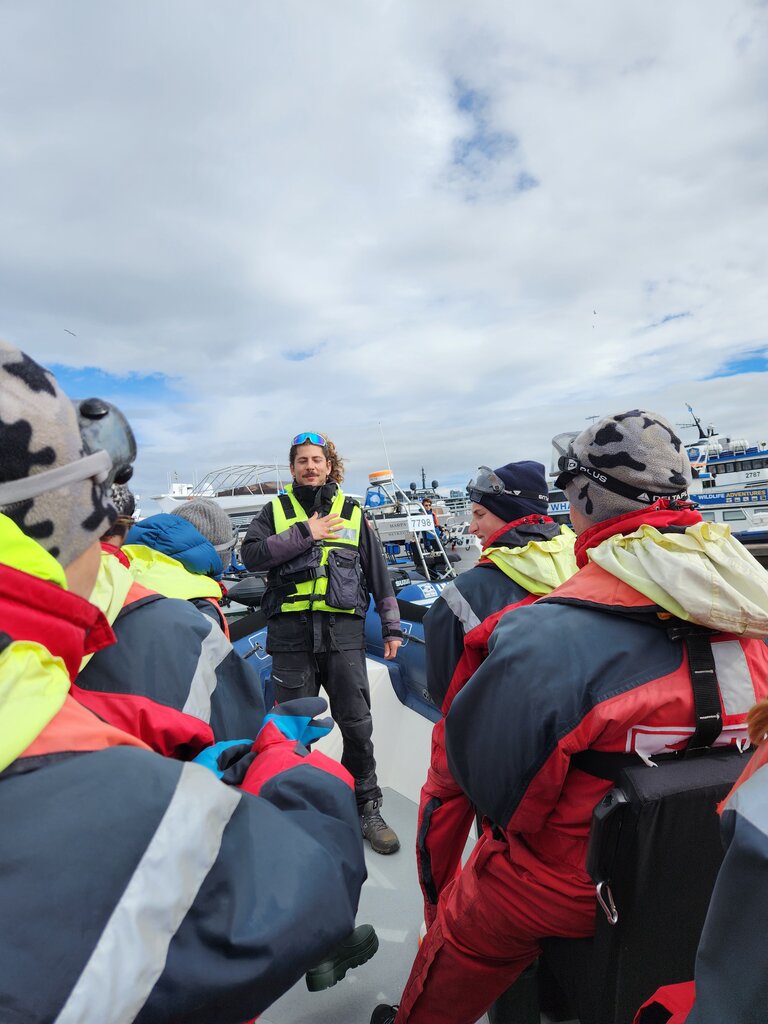
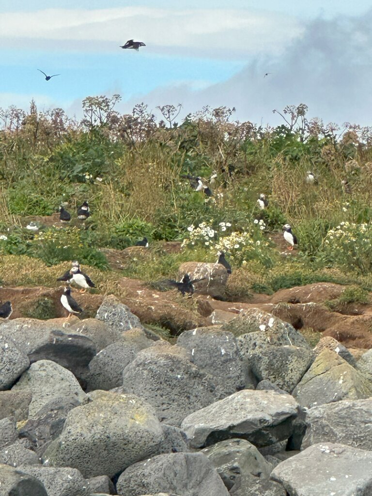
You can embark on a guided tour of the island by minibus, or take a boat tour circling the island of Heimaey, the only inhabited island of the Vestmannaeyjar, to see the sea caves (a few of which you can enter), cliffs, birdlife (including thousands upon thousands of puffins in the summer, from mid-June to early-September), and possibly some whales.
There are fast, exhilarating RIB-boats (rigid-hulled inflatable boats) that circle the island, as well as slower, larger boats (for windy days), but the RIB-boats are likelier to run—and are the more adventurous (and highly recommended) option of the two.
Heimaey offers incredible views toward South Coast, including everything from volcanoes (there most recent eruption occurred in the 1970s) to glaciers. There is great hiking here, too, although the terrain is steep.
If you’re up for a scenic hike or two, consider the below excursions.
Walk up to the crater of Eldfell (“the Mountain of Fire"). Eldfell is a volcano that was formed in a volcanic eruption that began without any warning just outside the town of Heimaey on January 23, 1973. There is also a folk museum that tells the story of Tyrkjaránið, the so-called Turkish Abductions of 1627, considered to be the most horrific event in the nation‘s history.
Hike to the top of Herjólfsdalur, the location of the popular annual music festival Þjóðhátíð, which will challenge you, but it is worth it for the exceptional views over the islands.
Climb to the highest peak in Westman Islands, Heimaklettur, which requires using wooden ladders to get to the top—900 feet above sea level.
Places to eat and drink on the island include the below:
- Gott Restaurant
- SLIPPURINN
- The Brothers Brewery
Spend the night in the islands before heading back to the mainland tomorrow.
Day 3: South Coast, waterfalls, black-sand beaches, and cliffs

Wake up and consider a morning hike or a boat ride while still enjoying the Westman Islands. Then, take the ferry back to the mainland.
Your first stop back out on Ring Road is Seljalandsfoss waterfall, with access from behind just a few minutes from the parking lot. Note that the ground is uneven in a few places, and there are stairs on one side. Standing in a cave under the cliff, witness the water come roaring down 20-30 feet in front of you. Pay attention to the direction of the wind or wear a rain jacket (or both). When viewed from behind, spot two, smaller waterfalls to the right, as well.
Next, along Route 1, locate the powerful Skógafoss Waterfall. Skógafoss marks the beginning of the 16-mile Fimmvörðuháls Trail, which ends in Thórsmörk. Admire the waterfall from the bottom, just a 2-minute walk from the parking lot, or if you are up for it, find the stairs to the right and climb up for a different perspective. At the top, walk along the canyon for a bit to see more waterfalls along “Waterfall Way” before turning around.
Note: Depending on snow conditions, this may not be possible.
Then, make your way to the Dyrhólaey arch and cliffs. At Dyrhólaey, there are two parking lots where you can see the famous arch. (The one high on the hill offers the better view.) Take the bumpy, dirt road to your right as you enter. From the top, spot a lighthouse and great views looking further west, along a black-sand beach that reaches as far as you can see. Look for birds flying around; they nest along the cliffside.
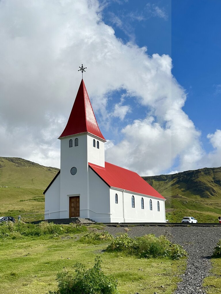
As you near Vík, along Route 1, look for the turnoff to Reynisfjara Beach, past a pretty church, as you drive toward the water. This black-rock beach (not as fine-grain as the one in Vík) is most famous for the Reynisdrangar Columns—huge, hexagonal basalt columns rising up out of the sand. Walk 1-2 minutes around the cliffs to the left, as you face the ocean, to find a couple of large caves, as well.
Next, reach Vík. While the town itself is fairly small, its proximity to several great sights more than makes up for it. You can even explore the area in the evening, after the large crowds dissipate, or before the crowds arrive the next day. Toward the water, look for a black-sand beach with high cliffs on the right side, often filled with soaring and nesting birds.
Continue about 50 minutes further along Route 1 to the town of Kirkjubæjarklaustur. If you have more time, just a short drive away is Fjaðrárgljúfur Canyon, where the rock formations look like they’re from another world. There is a trail less than 1 mile from the parking lot, along the ridge of the canyon, that is home to some amazing viewpoints—where the river curves around these strange rock cliffs. Admire the views along the way, and venture as far as you like.
Spend the night in Kirkjubæjarklaustur at your leisure.
Chat with a local specialist who can help organize your trip.
Day 4: Discover Skaftafell, Svartifoss, and Jökulsárlón Glacier Lagoon

Today, explore Iceland's glaciers, ending at the Jökulsárlón Glacier Lagoon (which is just under 2 hours from Kirkjubæjarklaustur, or 3.5 hours roundtrip). You can also continue to Höfn, where there is a great visitor center on the glacier and nearby area, and several restaurants serving very fresh seafood—langoustine and lobster are the specialties.
Depending on your preference, and where you spend the night, consider the below stops along the way.
Visit Skaftafell, where you could spend many days hiking the trails all around. If short on time, the most popular hike leads to Svartifoss, a thin waterfall surrounded by columns of basalt. The 3-mile hike offers great views alongside the river and toward the ocean in the distance. For further exploration, feel free to join an ice cave tour, a glacier walk, or embark on an ice climbing excursion.
Next, a quick trip off the main road will bring you into Hof, where you can check out Hofskirkja, the turf church. The act of covering the roof with turf dates back to medieval times, and was practiced throughout Europe to offer protection from harsh weather.
Just a few minutes before Jökulsárlón Glacier, you will find another glacier lagoon about 10 minutes from the parking lot—Fjallsárlón Glacier Lagoon. Here, you are much closer to the glacier than at Jökulsárlón, and you’ll have better views of all the cracks and crevices.
Next, visit Jökulsárlón Glacier Lagoon, with the chance to witness one of the most unique sights in Iceland: icebergs floating out to sea, and beached on the black sand. Climb the hill for a better view of the entire area.
Follow the river under the bridge to the ocean, and find many smaller icebergs along the black, sandy shores of "Diamond Beach," where the waves crash, creating a memorable sight. You may be fortunate to see seals, porpoises, or small whales that sometimes hang out in the lagoon or near the shore.
Following the active day, relax and unwind with another night in Kirkjubæjarklaustur.
Day 5: Bus to Thorsmork and scenic hiking trails

Drive back along the South Coast and transfer to a modified 4x4 bus to take you into Þórsmörk, or Thorsmork, and the highlands. Spend some time in the "Valley of Thor," and one of the premier hiking destinations in Iceland. You can camp, or stay in the Volcano Huts while you are there.
Consider picking up some groceries before heading to Thorsmork, as your only option for food is the LavaGrill (buffets, dinners, and packed lunches for day hikes are all available here).
This valley, named after Thor, the Nordic God of Thunder, has been carved away by glacial river floods that were caused by volcanic eruptions under the glaciers. You will notice ash and lava flows from the 2010 eruption of Eyjafjallajokull. The viewpoints are endless, and you can spend days hiking up mountains, along cliffs, and to waterfalls, volcanoes, and glaciers. The trails and terrain will vary, sometimes with necessary glacier river crossings (do not attempt to cross the glacial river Krossá by foot; always use the bridge).
When planning your hikes, you can purchase a Þórsmörk Trail Map at the Volcano Huts, which has a nice view of the trails in the area, as well as information about the landscapes and history.
Þórsmörk Panorama Trail leads you up and over the peak of the Valahnúkur mountain, where you get an impressive 360° view of Þórsmörk. From the top of Valahnúkur, head down to the Langidalur Hut, before heading back to the Volcano Huts, through the birch woods of the Húsadalur Valley. The trail is well-marked and accessible with manmade steps on its steepest parts, and can be added on to the below trails, as well.
Duration: 1.5-2 hours
Þórsmörk Highlights features all the best views of Þórsmörk and versatile terrain. The trail leads you through the birch woods of the Húsadalur Valley and up to the foothills of the Tindfjöll Mountains, where you turn onto the last part of the Laugavegur Hiking Trail, before descending back to the Volcano Huts. This trail is marked and accessible with the possibility to extend to other trails or cut short at convenient points. Duration: 3-4 hours
Tindfjöll Circle gives you a beautiful view over the Þórsmörk Nature Reserve with challenging terrain and access to some of the best viewpoints. You start by heading out over to the Langidalur Hut, and from there you ascend up to the foothills of the Tindfjöll Mountains. The hills below the Tindfjöll Mountains are steep, and you will have to traverse the meandering side of the hill with caution. As you make your way around the Tindfjöll Mountains, the trail leads onto the Stangarháls Ridge, where you descend down a steep trail, all the way down to the Krossá riverbed. From the bottom of the valley, you can head back to the Volcano Huts with the option of extending the trek by one hour, over the Valahnúkur mountain, or opt for an easy stroll through the Langidalur and Húsadalur woods, over to the Volcano Huts. Most parts of the trail are well-marked and it is fairly accessible, while also challenging in parts, due to steep sections on the paths.
Duration: 5-6 hours
Merkurrani Plateau Trail leads you up to the foothills of the Valahnúkur Mountain and onto the Merkurrani plateau, a short distance from the Volcano Huts. From there, head south, in the direction of Eyjafjallajökull, to the very end of the plateau to reach the steep Merkurrani Cliffs where the Krossá River has carved a sharp edge to the volcanic rock. Be careful, as the steep rock appears suddenly at your feet. From the cliffs, enjoy the great view over the Krossá River, Eyjafjallajökull, and the surrounding mountains of Þórsmörk. Head down to the black sands of the Markarfljót Riverbed where the contrasts of the volcanic ash and the green hills of Þórsmörk are very clear. On your way to the Volcano Huts, make time for a short stop at the Sóttarhellir Cave.
Duration: 2-3 hours
Stakkholtsgjá Canyon is on the south side of Krossá, and is accessible by a 15-minute bus ride from the Volcano Huts, once a day, at 12:30 pm. The bus lets you off at the mouth of the canyon and picks you up again, 2 hours later, to return to the Volcano Huts. The canyon is also accessible by foot, 1 hour each way. When walking, you cross the Krossá River on a footbridge close to the canyon. As you enter the canyon, skip across a small river and walk along it to the end of the canyon. On your way, enjoy an impressive view upon the 330-foot- high cliffs, towering above your head. The riverbed leads you to a narrow passage, on the left side, at the very bottom of the canyon. Enter the actual Stakkholtsgjá Ravine itself. Continue up a pile of large boulders to where you can see the river cascade down into the ravine, in a beautiful waterfall. The canyon offers an easy but rewarding hike. Be careful, or you might end up with your feet wet when crossing the river, and be careful of any falling rocks, or ice during the winter, from the cliffs above.
Duration: 2-4 hours
Additionally, you can take a guided hiking tour in Þórsmörk to Stakkholtsgjá Waterfall. Depart from 12:15 pm from Volcano Huts and embark on an excursion in the canyon that lasts 2 hours and 30 minutes.
You can also enjoy a trip to the LavaSPA natural pool and sauna. By the edge of the Húsadalur woods, find a small geothermal pool, sauna, and showers. The manmade pool is heated naturally and is around 90°. As a guest of Volcano Huts, this is included in your stay. You can also reserve massage appointments if desired.
Day 6: Drive the South Coast and explore Reykjavík

Leave Thorsmork in the afternoon and drive back along the South Coast toward Reykjavík to spend your last evening with a delicious meal and a taste of the nightlife. Visit any of the destinations you may have missed on the drive out, or stop at some of the below suggestions:
- Reykjadalur hot spring river (just after Selfoss): Reykjadalur (“Smoky Valley") is home to an active, geothermal area and hot springs. Hike from the trailhead north to Reykjadalur for less than an hour before you arrive at a hot river coursing through the valley. The water temperature can vary by location, so find a spot that's right for you.
- Seljavallalaug pool: A short distance after Skógafoss, make a detour to Seljavallalaug, one of the oldest swimming pools in the country, built in 1923. Look for the small sign to Seljavellir. A short, scenic hike will take you to the relaxing pool.
- Urriðafoss: As you reach the end of your South Coast drive, consider one last waterfall sighting. While Urriðafoss may not be considered as stunning as Skógafoss or Seljalandsfoss, it makes up for it in other ways. Urriðafoss is the largest-volume waterfall in Iceland, both very wide and very loud. It’s only a short trip from the Ring Road and a great finale to exploring the south.
- Kerið Crater: Just a quick detour from Route 1 on your way back to Reykjavík, hike around the top of Kerið Crater and enjoy views of its blue lake at the bottom.
- Raufarhólshellir lava tunnel: Explore Raufarhólshellir, Iceland’s most famous and longest lava tunnel, with a tour. There is a 1-hour option, as well as a more adventurous, 3-4-hour expedition to the bottom of the cave.
- Hellisheiðarvirkjun: Hellisheiði Power Plant is the newest and largest of Iceland’s six power plants. Obtain tickets to the Geothermal Energy Exhibition upon arrival. Tours start at about 30 minutes long.
- Mýrdalsjökull Glacier: For a memorable adventure, gain access to Mýrdalsjökull via the Sólheimajökull outlet, the most popular place in the country for ice-climbing and glacier hiking.
Following the last of your nature tours, take some time to explore Reykjavik. Walk through compact downtown to check out the unique street art scene. Head to the water for the Sun Voyager Sculpture and the Harpa Concert Hall, with its unique, glass architecture. Visit Hallgrímskirkja, a church on the hill, and take the elevator to the top of the tower for a great view of the city below and panoramic views of the area.
If the need arises to escape inclement weather, consider visiting a few museums in town, such as the Northern Lights Center, Saga Museum, Marine Museum, or Whales of Iceland Exhibition. You can also join a whale watching tour from Reykjavík Harbour, and snack on a world-famous hot dog at Bæjarins Beztu Pylsur.
For delicious lunch and dinner recommendations, consider the below:
- Messinn
- Sea Barron
- Kol Restaurant
- The Coocoo's Nest
- Kaffivagninn (lunch only)
- Café Loki
If you are interested in checking out Reykjavík’s nightlife scene, visit the following bars:
- Craft Cocktails
- Mikkeller & Friends
- Skúli Craft Bar
- KEX Hostel Bar (live music on weekends)
Day 7: Visit the Reykjanes Peninsula and depart from Reykjavík

Spend your last day exploring more of Reykjavík. Stop by the Blue Lagoon on your drive to the airport, where you can enjoy one, last geothermal soak before you fly home.
If you have more time, visit some of the highlights around the Reykjanes Peninsula. The following places are often missed by travelers quickly traveling between Reykjavik and KEF airport for departure. With a bit more time, you can explore lava fields, geothermal areas, lighthouses, and small fishing towns.
These places are listed east to west, as you drive from Reykjavik to KEF clockwise around the peninsula:
- Krýsuvík geothermal area: While you can walk around the area near the parking lot in as little as 5 minutes, take your time to see the steam vents and hot pools up close. Look up at the multicolored hills surrounding the area. There’s a short, steep trail up the hill, which offers great views on a clear day.
- Gunnuhver hot springs and geothermal area: Here, find a couple of bubbling and steaming mud pools. Gunnuhver is named after a female ghost who was said to be trapped in the hot springs more than 400 years ago. Temperatures are extremely hot, so stick to the walkways and viewing areas. While here, continue about 5 minutes to the cliffs to stop at Reykjanesviti lighthouse with beautiful views of Iceland from atop a hill.
- Bridge Between Continents (Europe Miðlína): This area is a great symbol of Icelandic geology. The Reykjanes Peninsula is on the Mid-Atlantic Ridge, which pulls apart a few centimeters every year. You can cross the bridge between the continental plates while you’re here, and look down at the gap below.
- Garður Lighthouse: About 15 minutes north of KEF, you will arrive at two lighthouses—one on the coast (older and not as stable), and a second a bit further inland. This scenic area can be a nice area to walk around and stretch your legs before boarding your return flight home.
Map