Best Multiday Treks in Iceland

Hesteyri to Kögur Loop in Hornstrandir, Westfjords

| Fast facts | |
|---|---|
| Duration | 3-5 days |
| Distance | 42 miles |
| Accommodation | Camping |
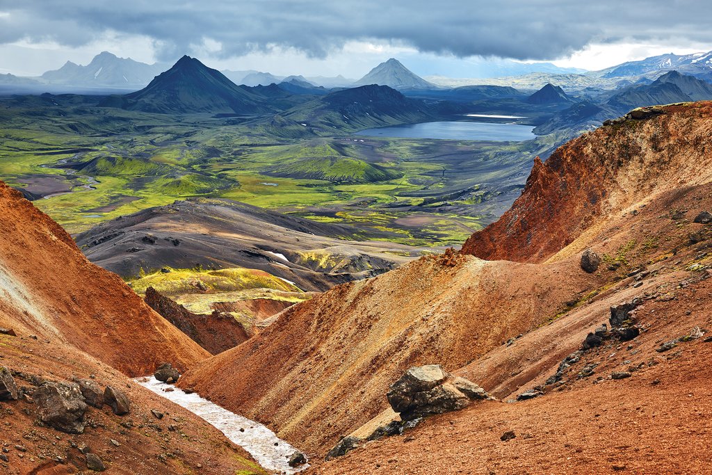
The 220-square-mile Hornstrandir Peninsula is one of the most remote places in Iceland, with miles of trails to explore and dozens of routes to choose from depending on desired length and duration. The loop from Hesteyri to Kögur is a good option for a 3-5 day, 42-mile hike. After arriving via the ferry to Hesteyri, you'll hike 10 miles (16 km) to the campsite at Sæból, where you can camp overnight or push on along the coast to the camp at Látrar, another 7 miles (11 km) away.
The next day, you'll cover 9 miles (15 km) to Fljótavík and then continue on to Kögur Mountain, where the cliff's edge rises sharply like a green wave about to break. The trail then loops back to Hesteyri via the campsite at Álfsfell. You can tackle the final 16 miles (26 km) all in one day or stretch out your time in one of the wildest and most remote parts of the country.
There are no roads on the Hornstrandir Peninsula. Ferries arrive from Ísafjörður to Hesteyri daily from June to August. Some parts of the trails are not well marked, so trekking on your own requires a good map and a GPS.
Laugavegur Trail, South Iceland

| Fast facts | |
|---|---|
| Duration | 3-4 days |
| Distance | 34 miles |
| Accommodation | Camping or huts |
The Laugavegur Trail is one of the most well-known routes in Iceland. A 34-mile (55-km) trail in the Fjallabak nature reserve, it runs from the hot springs and mountain hut at Landmannalaugar to the Þórsmörk glacial valley, up and over colorful rhyolite mountains and past steaming fumaroles. The trek can be tackled independently with proper care — you can camp or sleep in a mountain hut, and there is bus service to Reykjavík from either end of the trail. Huts cost ISK 6,500 (around $60) per night and come equipped with mattresses, a kitchen, and bathrooms. For ISK 1,200, you can pitch a tent. Tent campers can pay a small additional fee to use the hut kitchen.
Most people do the trek in 3-4 days. Several companies offer guided hikes, which include transport of your overnight gear to the next stop. Reaching either end of the trail requires driving on highland roads and fording several rivers, so if you drive yourself, you'll need to rent a 4WD approved for F roads. The area is only accessible from mid-June to mid-September.
Fimmvörðuháls Trail, South Iceland

Chat with a local specialist who can help organize your trip.
| Fast facts | |
|---|---|
| Duration | 1-2 days |
| Distance | 18 miles |
| Accommodation | Hut |
The Fimmvörðuháls hiking trail runs from Skógar to Þórsmörk and covers 18 miles (30 km), taking in views over the south coast and the diverse landscape of the Þórsmörk Nature Reserve. The trail passes between two ice caps, traverses past waterfalls, canyons, birch forests, and verdant green mountains, and crosses some of the new lava fields created by the Eyjafjallajökull eruption. You could do it all in one day, but most people spread it over two days, overnighting at one of the trail's mountain huts. The Fimmvörðuskáli hut is located about halfway along the route — just be sure to book it in advance.
As with other treks, the best time to go is during the long days of summer, when there's ample daylight and temperatures are milder. Buses run from Reykjavík to Þórsmörk in the summer months. If you drive yourself, you'll need a 4WD vehicle.
Nupstaðaskogar to Skaftafell, South Iceland

| Fast facts | |
|---|---|
| Duration | 5 days |
| Distance | 37 miles |
| Accommodation | Camping or hut |
The five-day trek from Nupstaðaskogar to Skaftafell traverses some of Vatnajökull National Park's most beautiful landscapes. The route winds across glaciers and over mountains, through birch forests, wildflower-dotted valleys, and past glacier lagoons filled with icebergs. While Skaftafell is located close to the Ring Road, reaching Nupstaðaskogar requires a 4WD vehicle. There are both campsites and mountain huts located along the trail and most are open from May through September. Guided treks are available from June to August.
Seyðisfjörður to Borgarfjörður, East Fjords

| Fast facts | |
|---|---|
| Duration | 4 days |
| Distance | 45 miles |
| Accommodation | Huts |
The East Fjords are one of the best areas for long-distance hiking in Iceland—while it's one of the less visited areas of the country, its mountainous peninsulas are crisscrossed with hiking trails. For a longer trek, try the Víknaslóðir, "The trails of the inlets." You'd need 10 days to tackle it all, but you can cover a scenic 45-mile (74 km) stretch of the hut-to-hut route through majestic fjords from Seyðisfjörður to Borgarfjörður in just four days. The East Fjords are an eight-hour drive from Reykjavík. Flights from the capital to Egilsstaðir take one hour. The hiking season runs from mid-June through August.
Ásbyrgi Canyon to Dettifoss, North Iceland

| Fast facts | |
|---|---|
| Duration | 2 days |
| Distance | 20 miles |
| Accommodation | Camping |
Set in the north of Iceland, Asbyrgi Canyon is said to have been created when a Norse god's horse touched its hoof to the earth. It left a half-mile wide and two-mile long impression in the 300-foot tall cliffs and created one of the country's most stunning canyons.
From just behind the visitor's center, you can set out on a two-day, 20-mile (32 km) hike along the Jökulsárgljúfur canyon, through birch forest, over rivers and past waterfalls, to the mighty Dettifoss, one of the largest waterfalls in Europe. There are no huts along the route. There's one campsite, which is open from June through mid-September, and you'll need to bring your camping gear and your own water. In the summer months, there's a bus that shuttles between Ásbyrgi and Dettifoss, along with the nearby towns of Akureyri and Húsavík.
Map
