

Highlights
- Explore Reykjavík's downtown scene, with street art, cafés, and shops
- Hike the Látrabjarg bird cliffs and visit the Rauðasandur red-sand beach
- Marvel at Goðafoss, the "Waterfall of the Gods" in North Iceland
- Look for wildlife in the Westfjords like seals, arctic foxes, and puffins
Brief Itinerary
| Day | Highlights | Overnight |
|---|---|---|
| Day 1 | Arrive in Reykjavík | Reykjavík |
| Day 2 | Drive to the Snæfellsnes Peninsula | Snæfellsnes Peninsula |
| Day 3 | Explore More of the Snæfellsnes Peninsula | Snæfellsnes Peninsula |
| Day 4 | Ferry to the Westfjords | Patreksfjörður |
| Day 5 | Explore the Southern Westfjords, Drive to Ísafjörður | Ísafjörður |
| Day 6 | Outdoor Activities in Ísafjörður | Ísafjörður |
| Day 7 | Drive to Akureyri | Akureyri |
| Day 8 | Drive to Lake Mývatn via Goðafoss, Whale Watching & Waterfalls | Lake Mývatn |
| Day 9 | Explore the Geological Wonders of Lake Mývatn | Lake Mývatn |
| Day 10 | Drive to Akureyri, Fly to Reykjavík | Reykjavík |
| Day 11 | Depart Reykjavík |
Detailed Itinerary
Day 1: Arrive in Reykjavík

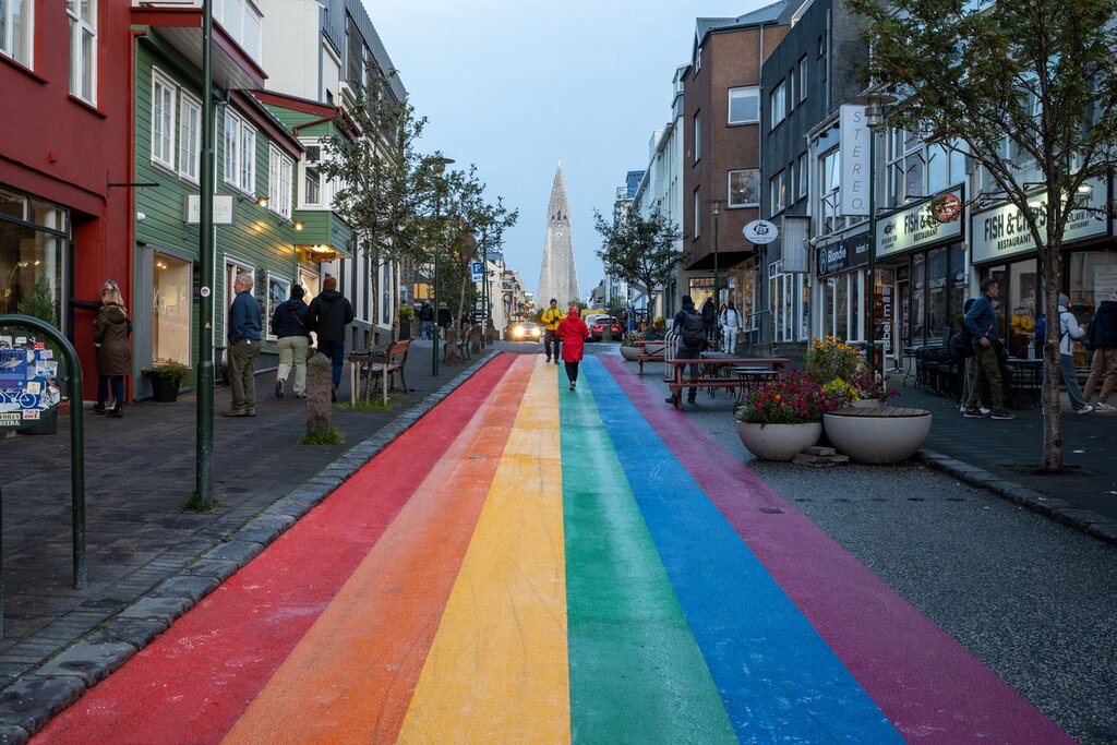
Arrive at Keflavík International Airport, pick up your rental car, and drive to Reykjavík (30 minutes) for a relaxing day exploring the compact downtown area. Start with a stroll along the water past the Sun Voyager sculpture, and to the Harpa Cultural Center with its cool, contemporary architecture. Then, visit Hallgrímskirkja church on the hill and take the elevator to the tower for a great overview of the city below and panoramic views of the area.
Join a whale watching tour, or spend some time learning about Iceland's history at the Settlement Exhibition or the National Museum of Iceland. Snack on a world-famous hot dog at Bæjarins Beztu Pylsur or hop between cafés. In the evening, enjoy a variety of top-tier fish restaurants and Reykjavík's nightlife.
Day 2: Drive to the Snæfellsnes Peninsula
Drive north from Reykjavík and stop in Borgarnes for a nice walk along the path near the water. While in Borgarnes, you can learn more about the settlement age of Iceland at the Settlement Center or grab a bite. On the way, you can stop at Glymur Waterfall for a two-hour round-trip hike along the narrow canyon up to the top of Iceland's tallest waterfall.
Continue to the Snæfellsnes Peninsula, sometimes referred to as "little Iceland" because here you can find a little bit of everything that Iceland has to offer: basalt columns, tiny fishing villages, coastal cliff walks past arches and other rock formations, lava fields, volcanic craters, black-sand beaches, waterfalls, lava caves, and more. Your first stop will be the Gerðuberg basalt cliffs, where strange basalt columns rise out of the earth. Park the car and walk around exploring and getting a closer look. Next, walk through the start of the Búðahraun lava fields on the coast, covered in moss.
Day 3: Explore More of the Snæfellsnes Peninsula
Start your day with a walk along the cliff-side paths at Arnarstapi, where you'll see lava formations and arches in the rocks. In Hellnar, stop at the small Fjöruhúsið café near the water to taste their delicious fish soup and enjoy the setting. Next, you'll see the huge Londrangar lava formations, which you can view from afar or walk 15 minutes to see them up close. A little further along the road is the visitor center for the peninsula, where you can learn more about the volcanic system and the area.
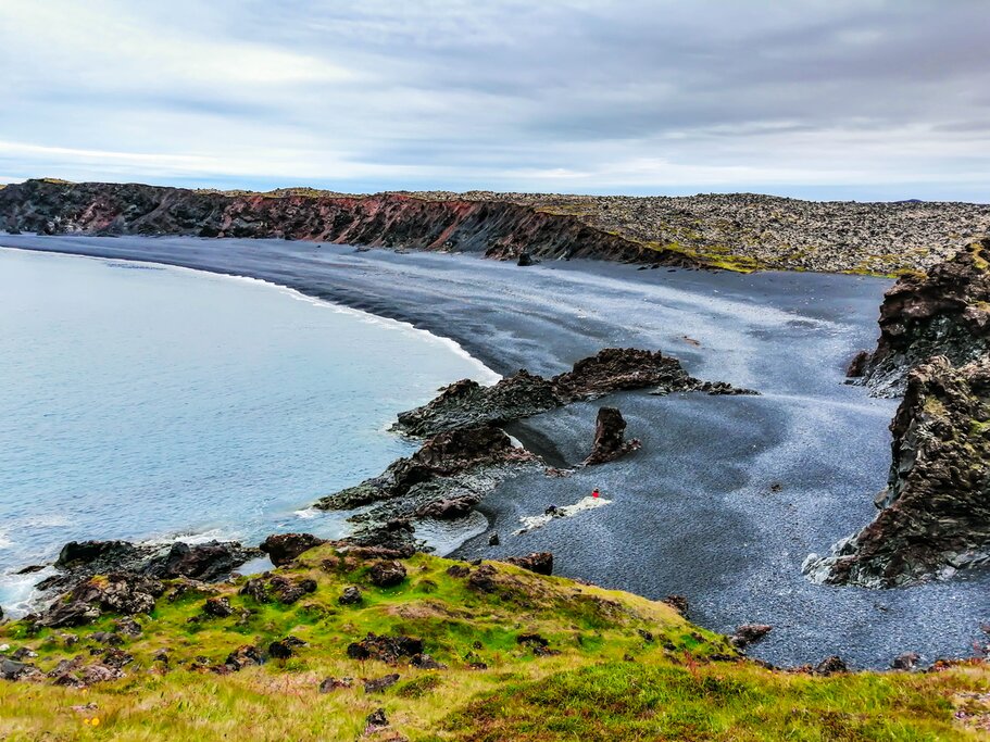
Take a stroll along Djúpalónssandur, a black-sand beach with debris from a shipwreck (photographers should capture some shots of the rusted, mangled metal pieces on the black sand). Here you'll find four stones of different sizes, once used by sea captains to test the strength of people wanting to join their crew. Continue your drive around the other side of the peninsula and end your day with a visit to Kirkjufellsfoss waterfall with Kirkjufell mountain in the background (one of Iceland's most photographed).
Day 4: Ferry to the Westfjords

Finish exploring the Snæfellsnes Peninsula with a drive into the Berserkjahraun lava fields before you drive to Stykkishólmur, where you can catch a three-hour ferry north to the Westfjords (departure times vary and are limited in the winter season; you can also make the drive about 3.5 hours instead). While in Stykkishólmur, you can stop by the Volcano Museum and enjoy some fresh mussels by the harbor. Spend the night around Patreksfjörður. If you have more time, start exploring some of the nearby sights listed tomorrow.
Day 5: Explore the Southern Westfjords, Drive to Ísafjörður

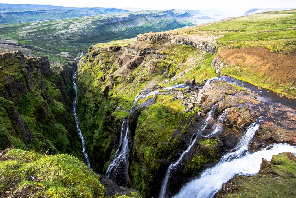
Start your day with a hike along the edge of the Látrabjarg bird cliffs with incredible views over the waters below. Take a break at the beaches of Rauðasandur and Breiðavík. Walk around the Gardar BA 64 shipwreck, beached on the side of the road. Walk around several waterfalls below the massive Dynjandi waterfall in a beautiful fjord setting. Finish your drive through Iceland's longest tunnel, arriving in Ísafjörður to enjoy one of the best fish meals in the country.
Chat with a local specialist who can help organize your trip.
Day 6: Outdoor Activities in Ísafjörður

Ísafjörður is the heart of the Westfjords and the region's largest town. It's a great home base and a pleasant town for a stroll. From here, you can drive to the region's highlights, such as Dynjandi Waterfall, hike above the fjords, kayak the calm waters around the coast, or day-trip to Hornstrandir Nature Preserve. While in town, visit the Ísafjörður Maritime Museum, join a cultural and historical walking tour of the town, or eat all the fish you ever wanted at Tjoruhusid, named best seafood in Europe a few years back.
A couple of options for how to spend your time:
- Hike around Ísafjörður and up the sides of the mountains to see the fjords below.
- Take a boat ride and hiking tour of Hornstrandir Natural Preserve, one of the most remote and scenic areas of Iceland.
- Kayak the calm fjord waters or take a longer paddle between fjords or to the island of Vigur to see birdlife and sealife.
- Go mountain biking around the avalanche barrier of Ísafjördur with an off-road tour that leads you into the Icelandic "forest" and over avalanche walls, with short single track for beginners and a few short downhills.
- Take an Icelandic horseback riding tour through the lush Sandá Valley, where you can experience the Icelandic countryside while getting acquainted with friendly Icelandic horses.
Day 7: Drive to Akureyri
Start the morning with a hike up to "Trolls Seat" for one last view back down on Ísafjörður before taking a scenic drive along the fjords. Take an optional stop at the Icelandic Sorcery & Witchcraft Museum along the way before you rejoin the Ring Road and continue to Akureyri, Iceland's second city. Sitting on Iceland's longest fjord, this city makes a great base for exploring the north. While here, be sure to check out the thriving restaurant, café, and bar scene, and visit the Akureyrarkirkja church on the hill. With more time, follow the path along the calm old harbor and water to see more of the picturesque fjord.
Day 8: Drive to Lake Mývatn via Goðafoss, Whale Watching & Waterfalls
Spend your morning exploring the rest of Akureyri's downtown area before you get on the road (Route 1) toward Húsavík and Lake Mývatn. Be sure to look back towards Akureyri from the other side of the fjord; you can see the mountains behind the town, which makes for a great photograph. Take the scenic route past Húsavík, where you'll find whales, porpoises, and seabirds a few minutes from the harbor, and enjoy the views as you pass Ásbyrgi canyon, and the waterfalls Dettifoss and Selfoss.
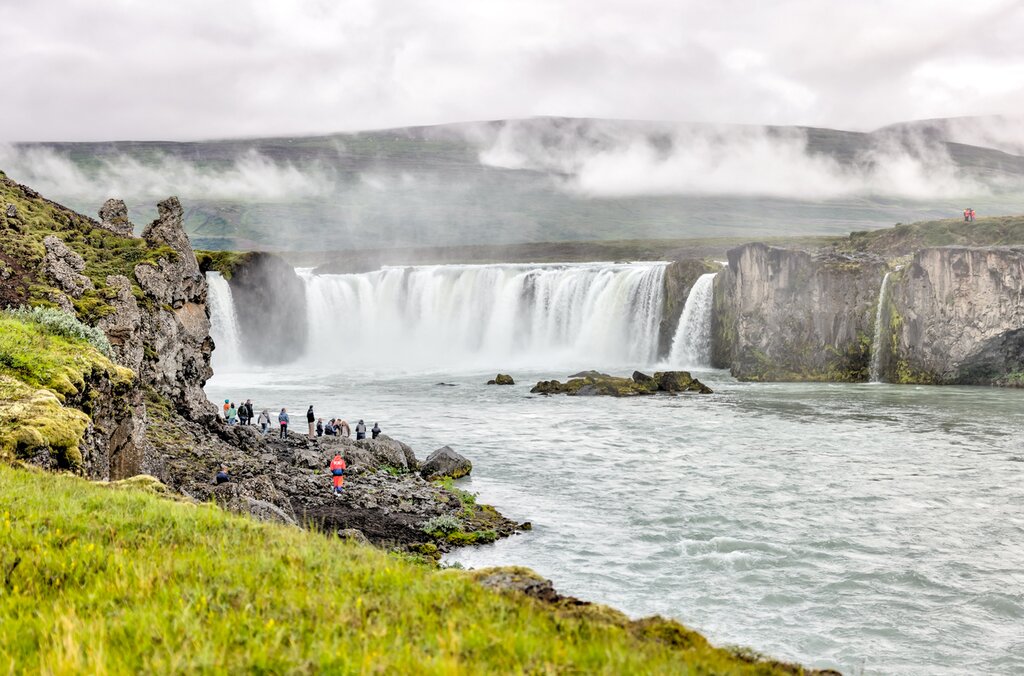
It's impossible to miss Goðafoss, the "Waterfall of the Gods", just off Route 1. Hike a couple of minutes to see the waterfall up close, or take a longer walk around to see it from multiple perspectives. The waterfall was named when Iceland converted to Christianity in 1000 CE. The legend says that when Þorgeir Þorkelsson, local chieftain and law speaker, made the tough decision to convert the country from the old Nordic gods to Christianity (to prevent war), he threw the old gods into the falls to symbolize the change to the new era.
Day 9: Explore the Geological Wonders of Lake Mývatn
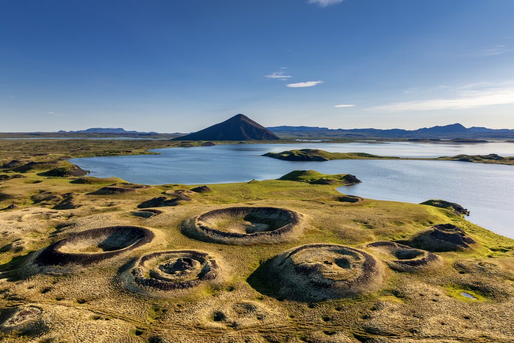
The area surrounding Lake Mývatn has the highest concentration of volcanic and geothermal sights in Iceland. In one day, you can explore pseudocraters, rock formations, and lava fields, hike up and around a volcanic crater, take a dip in a cave thermal pool, watch bubbling mud pools and steam vents, and hike through a lava area from another world.
Finish the day relaxing at the Jarðböðin Nature Baths, the north's equivalent of the Blue Lagoon (but with fewer people, lower prices, and better views). You won't find spa extras, but you will find a couple of large geothermal pools, a sauna, and a steam room. You can enjoy views down over the lava fields and the craters around Lake Mývatn as you sit in the mineral water.
Day 10: Drive to Akureyi, Fly to Reykjavík
Head back to Reykjavík today, either on a domestic flight (about 45 minutes from Akureyri) or by driving (about 4.5 hours from Akureyri). Enjoy your final evening in the Icelandic capital however you like.
Day 11: Depart Reykjavík
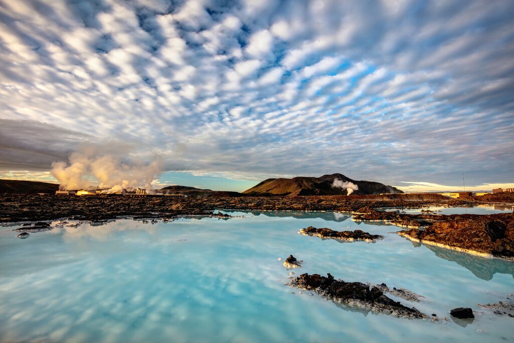
If you have extra time today, explore the often-missed Reykjanes Peninsula or take one final geothermal soak at the Blue Lagoon. When the time comes, drive to the airport, return your rental car, and catch your departing flight. Safe travels!
More Great Iceland Itineraries
Looking for more inspiration for your trip to Iceland? Check out these other Iceland itineraries, explore different ways to spend 11 days in Iceland, or discover the best time to visit Iceland.
Map
