
Highlights
- Trek for 2 weeks through the spectacular and varied Limi Valley
- Follow the Karnali river as it cuts through spectacular rock formations
- Bathe in the healing Chugzur hot springs
- Cross over breathtaking 16,000 ft (4,900 m) passes
- Wander through ancient Buddhist monasteries
Overview
The Limi valley is the only remaining place where you can still witness the vibrant Tibetan culture and lifestyle, due to the matrimonial relationship between Western Nepal and Tibet. Your trek follows the ancient salt trading and pilgrimage route to the border of Nepal and China, crossing the Nara La pass (15,000 ft/ 4,620 m) and Nyalu La (16,000 ft/ 4,900 m) with spectacular views of the Himalaya.
During this trek, you will have the chance to spot the elusive snow leopard, bharal (Himalayan blue sheep), jackals, kiang (Tibetan wild ass), and musk deer. This trip will take a total of 18 days, starting and ending in Kathmandu. The trek will take approximately 15 days, and will be moderate to strenuous, including high altitude trekking for many hours each day. The majority of this trek will take place above 10,000 ft (3,000 m), so you may feel the effects of elevation. The best season for this hike is from May to October, as the passes are likely to be covered in snow the rest of the year.
Brief Itinerary
| Day | Highlights | Overnight |
|---|---|---|
| Day 1 | Welcome to Kathmandu! | Kathmandu |
| Day 2 | Explore Kathmandu | Kathmandu |
| Day 3 | Flight from Kathmandu to Nepalgunj | Nepalgunj |
| Day 4 | Flight to Simikot | Simikot |
| Day 5 | Trek from Simikot to Dharapori | Dharapori |
| Day 6 | Trek from Dharapori to Kermi | Kermi |
| Day 7 | Trek from Kermi to Yalbang | Yalbang |
| Day 8 | Trek from Yalbang to Tumkot Khola | Tumkot |
| Day 9 | Trek from Tumkot to Thado Dunga | Thado Dunga |
| Day 10 | Trek from Yari to Hilsa via Nara La Pass | Hilsa |
| Day 11 | Trek from Hilsa to Manipeme | Manipeme |
| Day 12 | Trek from Manipeme to Til Village | Til Village |
| Day 13 | Trek from Til village to Chagzur hot springs via Halji | Chagzur hot springs |
| Day 14 | Rest day at Chagzur (Tashi Thang) hot spring | Chagzur hot springs |
| Day 15 | Trek to Jade/Nyalu base camp | Jade/ Nyalu base camp |
| Day 16 | Trek from Nyalu base camp to Sheng Jungma | Sheng Jungma |
| Day 17 | Trek from Sheng Jungma to Langdogd Base | Landogd Base |
| Day 18 | Trek from Langdogd Base to Lekh Dinga | Lekh Dinga |
| Day 19 | Trek from Lekh Dinga to Simikot | Simikot |
| Day 20 | Flight Simikot - Nepalgunj – Kathmandu |
Detailed Itinerary
Day 1: Welcome to Kathmandu!

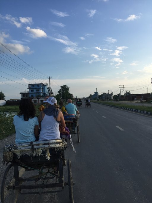
As you fly into Kathmandu, you'll have beautiful views over the valley, the Himalaya, and of the terraced fields below. After going through customs, a representative will be waiting to guide you through the initial culture shock of Kathmandu’s narrow, winding streets and get you settled into your hotel. Once you've settled in, head out and visit one of Kathmandu's cultural highlights. In the evening, the tourist hub of Thamel is a good place to grab your first meal, with a variety of restaurants to chose from offering both Western and local Nepali dishes.
Day 2: Explore Kathmandu

Kathmandu has a special atmosphere during the early morning hours when the city is slowly coming to life yet not too chaotic. It's a great time to walk and explore the streets or have a chai overlooking one of the local courtyards or durbar squares. There are a number of ways you can spend the day given the many incredible sights around the Kathmandu Valley. Later in the evening, head out for dinner at one of the city's great eateries, or your specialist can arrange a home-cooked dinner with a local family.
Day 3: Fly from Kathmandu to Nepalgunj
A spectacular afternoon flight takes you to Mahendra Airport in Nepalgunj, the largest city in the steamy Terai, the border region of western Nepal and India. The drive to the hotel passes through an old village, a step back in time into the 'old' Nepal. Stay the night in a comfortable and air-conditioned hotel, ensuring a good night's sleep as the wake up is early the next morning.
Day 4: Fly to Simikot

Wake up early the next morning for the flight north to Simikot, the district headquarters of Humla, situated up on a ridge overlooking the Humla Karnali River. The flight is spectacular, cruising just over the tops of a mass of snow-covered peaks. If the flight is on time, you will arrive before lunch and will be met by your friendly trek crew.
Simikot is an eclectic village, and its location as the gateway to Mount Kailash and Western Tibet gives it a diverse feel. A mix of local Humla and Tibetan culture provides endless and fascinating opportunities for exploration. Simikot is located at almost 10,000 ft (3,000 m) of elevation, so you will likely feel the effects of altitude. Take it easy today, making sure you drink plenty of water and taking breaks as you wander around the village.
Day 5: Simikot to Dharapori

Your trek today starts with a short climb of about an hour to a little pass that's just over 9,800 ft (3000 m). After the pass, it's a long and steep descent to Dharapori. Your trek today will take around 4-5 hours, and will take you high above the Karnali River, partly through pine forests, and pass through a few villages. Along the way, you will meet local people, both Hindu and Buddhist, who are sometimes carrying their heavy loads all the way up the steep trail. Tonight is your first night camping, with the site located near the Karnali River.
Day 6: Dharapori to Kermi

Your walk today is rather short, giving you a chance to recover. The trail keeps on following the Karnali River, sometimes high on the slope, with the river far below you, and sometimes dipping back down so that the trail is almost level with the water. This section of the river finds its way through narrow gorges with high rocky slopes. You will walk along fields of mainly barley, buckwheat, rice, and potatoes.
In the afternoon you can relax in one of the two natural hot springs close to the village. Itʼs a 30-minute uphill walk, passing Kermi village. Kermi is a small agricultural village and is the first completely Buddhist village on the trail (from Kermi onwards, all the villages are Buddhist). There are two interesting monasteries close to Kermi: Laikyo Gompa, a few hundred years old, is about 45 minutes from the campsite and Lhundrup Choeling Gompa is about 30 minutes from the campsite. Both are seldom visited by tourists.
Day 7: Kermi to Yalbang

Today the trail is flat or slightly uphill, passing alongside fields planted with barley and buckwheat. When it is sunny, you might see beautiful lizards sunning themselves on rocks. After 2 hours you will cross a small pass, after which it is a steep descent of about 20 minutes until you reach a big iron suspension bridge over the Sali River.
This section of the walk goes through beautiful pine forests. Below you, you will see the emerald green Karnali River. Once and a while you might meet caravans of mules and dzopas (a crossbreed of yak and cow). The travelers are mostly villagers from Simikot and the Nyinba Valley to the east of Simikot. They are going to (or are coming back from) Taklakot, just across the border with Tibet, to buy goods for trading.
You will reach Yalbang after 5-6 hours of trekking. Above the village, there is a beautiful monastery: the Namkha Khyung Dzong Monastery. You will notice you are getting near the monastery by a huge stone with a Tibetan mantra carved on it. The Namkha Khyung Dzong is the biggest monastery in the region, with around 130 monks living there. A Buddhist monk will be happy to show you around, after which you will be invited for tea upstairs. At 7 am and 4 pm there is a daily puja (Buddhist prayer ceremony) that you can attend.
Day 8: Yalbang to Tumkot Khola

Leaving Yalbang, the path goes high above the Karnali River again. After about 20 minutes you will pass the little village of Yangar. The path is mostly "Nepali Flat": flat parts, with some uphill, and some downhill. Some sections of the path are spectacularly carved out of the rocks, and you will find yourself walking in a kind of three-sided tunnel. You’ll notice the environment changing as it is getting rockier and the big pine trees make way for smaller bushes. You cross the Karnali River by a big wooden suspension bridge.
Here, the path climbs high above the Karnali River and along the upper side of a deep gorge. Below, you'll see the emerald green Karnali River. Along the way, you may encounter large flocks of sheep carrying salt, an old trade that still exists today. After 3-4 hours, you will arrive in the charming village of Muchu. Itʼs an hour walk to Tumkot—the main trail doesnʼt pass through Tumkot Village, but instead by some small teahouses and a campsite. The total trek today will take 6 hours.
The actual village of Tumkot is 20 minutes south of the trail. Close to the campsite and village lies the Dhungkar Choezom Monastery, one of the most important Sakya monasteries in the Tibetan region. It's a 20-30 minute climb to get to the monastery, but it's well worth the effort: this is the only Sakya Monastery in Humla, and one of the few monasteries of this lineage in Nepal.
Chat with a local specialist who can help organize your trip.
Day 9: Tumkot to Thado Dunga

Leaving Tumkot the trail climbs slowly but steadily, with a few steep climbs in between. Pretty soon after leaving the village, you will notice the landscape changing: it's getting more and more rocky and desolate. The few trees left are low junipers. Part of the trail goes over the dirt road that is being built at the moment.
It is still uncertain when and if the road will ever be finished. You will cross the small village Pani Palwang—a couple of teahouses along the road—which makes a nice place for a cup of tea or a lunch break. Itʼs another 1 ½ hour to Thado Dunga, just after Yari. Your trek today will take 7 hours total, and you will camp just past the Yari village.
Day 10: Yari to Hilsa via Nara La Pass

Today you cross the Nara La pass at 14,000 ft (4,330 m). Itʼs a long and tiring climb, but the views are your reward! As the trail climbs, the landscape gets more desolate. Trees disappear completely and the landscape looks more and more like Tibet. Sometimes you will encounter large caravans of mules or yaks (the bigger yaks are an especially impressive sight). You will pass a few teahouses at Tado Dunga, and from here the trail becomes steeper.
Itʼs still 2 hours climbing to the pass, and if there happens to be snow it will take a bit longer. Typically, this day's trek takes 5-6 hours. At about half an hour from the pass you will cross a few big tents (these are tent hotels, serving foods and drinks). You can see the Nara La pass in the distance, but due to the altitude, it's still a hard climb to get there. You will recognize the pass by the pile of stones (it brings good luck to add one!) and the strings of Tibetan prayer flags, carrying the prayers far away with the strong wind. You have breathtaking views ahead into Tibet and back towards Yari far below.
At the other side of the pass, it looks like you are in Tibet. You are surrounded by barren mountains in tones of brown, coppers, ash and dark yellows. From the pass, it’s a long descent to Hilsa, close to the border with Tibet.
Day 11: Hilsa to Manipeme

Hilsa is the nearest port of Tibet- during the high season you will see thousands of Indian pilgrims crossing the border towards Mount Kailash in Tibet. After breakfast, you will cross the suspension bridge of the Humla Karnali River and immediately turn north through the newly built road towards Limi Valley, as you cannot cross the Nepal-Tibet border. This valley is famous for snow leopards and bharal, Himalayan blue sheep. After trekking for 4-5 hours, you will camp at Manipeme at an elevation of 12,900 ft (3,930 m). The camp gets its name from the Mani Mantra engraved on a large rock.
Day 12: Manipeme to Til Village

From Manipeme you will cross the Chenglungma caravan campsite before coming to the old cave of Cha-sa Nam-ka Dzong. It is located just up the hill, below the trail in a rocky cliff, and faces south into the sun. Its convenient location and proximity to plentiful firewood have made it popular for retreats.
Today's distance looks short, but the trail from Hilsa to Til is a bit tough and takes close to 7 hours. It’s dry, sloping, and goes up and down. You are walking through the Trans Himalaya Dread Path, which gets its name from the rough terrain and the heavy pack animal traffic. Tread carefully on the trail as you navigate the yaks and sheep, which are returning from the border with fully loaded trading packs.
There are three villages in the Limi valley- Til, Halji, and Jang. Til is situated at approximately 13,500 ft (4,100 m) and is surrounded by barley fields at the western side of the village. It is the closest village to the Tibet-China border and is the smallest village among the three settlements. There are around 30 families living here. On the right side of the village, you'll find the300-year-old monastery of Kunzum Do-Nag monastery, which is worth paying a visit.
Day 13: Til village to Chagzur hot springs via Halji

Today’s trekking begins with a downhill walk for about an hour until you reach Tiljung. Just below Tiljung you will reach the Tagtsi Khola, the main tributary of Karnali River, which flows from the east along the Jang and Halji villages towards Til. From Tiljung, cross the suspension bridge over the river, then proceed right. Follow the Tagtsi River into the narrow valley towards the east for about two hours and you will reach another bridge over the same river. Cross the bridge and bear to the left. Then, walking northeast about half an hour, you will reach the beautiful plain area of Halji village.
Halji is the biggest and most important village in Limi, and its centrally located 800-year-old Rinchhen Ling Gompa monastery is a must-see. Visit the monastery and turn east, walking on the nice wide trail past the beautiful Buddhist entrance gate and Mani walls. From there, walk another 1.5 hours until you reach the village of Jang at 12,900 ft (3,930 m), which boasts a 250-year-old monastery. From Jang, another hour trek (bringing the total for the day to 7 hours) will bring you to your welcome destination: the Chagzur hot springs.
Day 14: Rest day at Chagzur (Tashi Thang) Hot Spring

Today is your rest day, after a long and tiring 10-day journey. However, you have two options: either a rest day with time to do laundry and relax in the natural hot-spring baths—or, if the weather is good, you will have an opportunity to see Mt. Kailash and Holy Lake Manasarovar in Tibet from Lapcha Syar 16,000 ft (4,900 m). For those trekkers who want to see a panoramic view of Kailash and Manasarovar, you will need to hire a truck (this can be easily arranged) as the road access from Tibet can be rough. Going up to the viewpoint and coming back to the campsite will take about 5-6 hours.
Day 15: Trek to Jade/Nyalu Base Camp

From Chagzur hot springs, as you walk towards Tagtsi, the old caravan trails of Humla-Manasorover and Humla-Limi will meet. About half an hour before reaching Tagtsi, you will reach a new settlement that has sprung up at Tugling. It has VHF telephone service and a restaurant run by Limi people.
From here to Nyalu base camp you have two options: if you cross the river there is a shorter way along a new road; a longer trail goes via Tagtsi, and is more beautiful. Just after crossing the Tagtsi bridge on your right, you will see one of the ruined villages of Limi. This ruined village used to be the oldest village in the Limi valley, known as Tshamdo or Zambuk (also known as the ruined village of Lama Palya). These days, only its ruins and the chorten (Buddhist stupa) can be seen.
From Zambuk, you need to cross Nyingchhu River, which enters to Tshomgo Lake. You can enjoy the beautiful scenery of Tshomgo Lake and the stream of Talung meadows. You can also see the camp of Limi and Humli shepherds and yak-herders at Jade/Nyalu base camp. Today's journey will take approximately 7 hours.
Day 16: Nyalu base camp to Sheng Jungma

Moving out of Nyalu base camp, it is about two to three hours climbing to get to the top of Nyalu Pass (14,000 ft/ 4,990 m). Standing a the top of the pass, you will be surrounded by several mountain ranges. Coming down from Nyalu Pass you will see a small, beautiful lake- this is Sheliman Lake, located at 15,000 ft (2,570 m).
From Sheliman Lake, you will descend towards Tshongsa meadow at 13,600 ft (4,140 m) and cross the Tshongsa River, where you will run into the first vegetation: a rhododendron forest. Passing by, you will also see the towering Tshongsa rocks and the beautiful Tshongsi Tsan waterfall (the wild Demon of Tshongsa). After trekking for 7 hours, an hour away from the Tshongsa rocks, you will reach the pastureland of Sheng Jungma, in the thicker jungle habitat.
Day 17: Sheng Jungma to Langdogd Base

Today your path takes you across the Tshongsa River. Start out along the left bank of Zhetse Khola (river) towards the east. Ascend for about 3-4 hours, then cross the same stream to the right. Before crossing the bridge, you can visit the summer camp of the Chyadok village herders, witness the beautiful scenery of Zhetse valley, and visit the campsite of the Dinga village herders (known as Langdogd Base).
Day 18: Langdogd Base to Lekh Dinga

From the campsite, you will ascend through the jungle towards Langdogd Pass, which sits at an elevation of 14,900 ft (4,550 m). From the pass, you will need to descend steeply through juniper and birch forests until you reach the Takhor Khola. After crossing the stream and walking for about 1.5 hours, you will reach the campsite of Laga Dinga, also known as Lekh Dinga at 12,800 ft (3,890 m). This is the summer village of Laga Dinga, and it used to be the autumn trading center for the Limi and southern Humli People. It is a lovely and pleasant place to spend the night.
Day 19: Lekh Dinga to Simikot

You will start your day today by passing the villages of Yapka and Tangin on your left, and Aul Dinga (Lower Dinga) on your right. From there, descend steeply for an hour and a half until you reach Yapka Khola, at 8,600 ft (2,600 m). After crossing the wooden bridge, climb towards the Thakuri village of Okhreni for a little over two hours.
From the village, walk straight about three hours along a new road until you reach Simikot Lagna. Here you will have a beautiful view of Nyinba valley. After a fifteen-minute walk downhill, you reach to Simikot, the district capital of Humla. After a 7-hour day, rest at a guest house in Simikot before continuing your journey back to Kathmandu the next day.
Day 20: Flight from Simikot - Nepalgunj – Kathmandu

Today, your trekking journey comes to an end. After an early breakfast, you will have little time to relax. Before too long you will make your way to the airstrip for your return journey to Kathmandu. In the afternoon, you will have some free time to visit further areas of interest or to simply carry out some last minute shopping in Kathmandu. Catch your flight home from Tribhuvan International Airport, or extend your stay in Nepal. Either way, know that the mountains you trekked through will stay with you forever, and come back soon!